FIELDS
|
| TM 1838: 001: |
OS. 1886/1927: 48 |
Name where known: |
Location 001: |
|
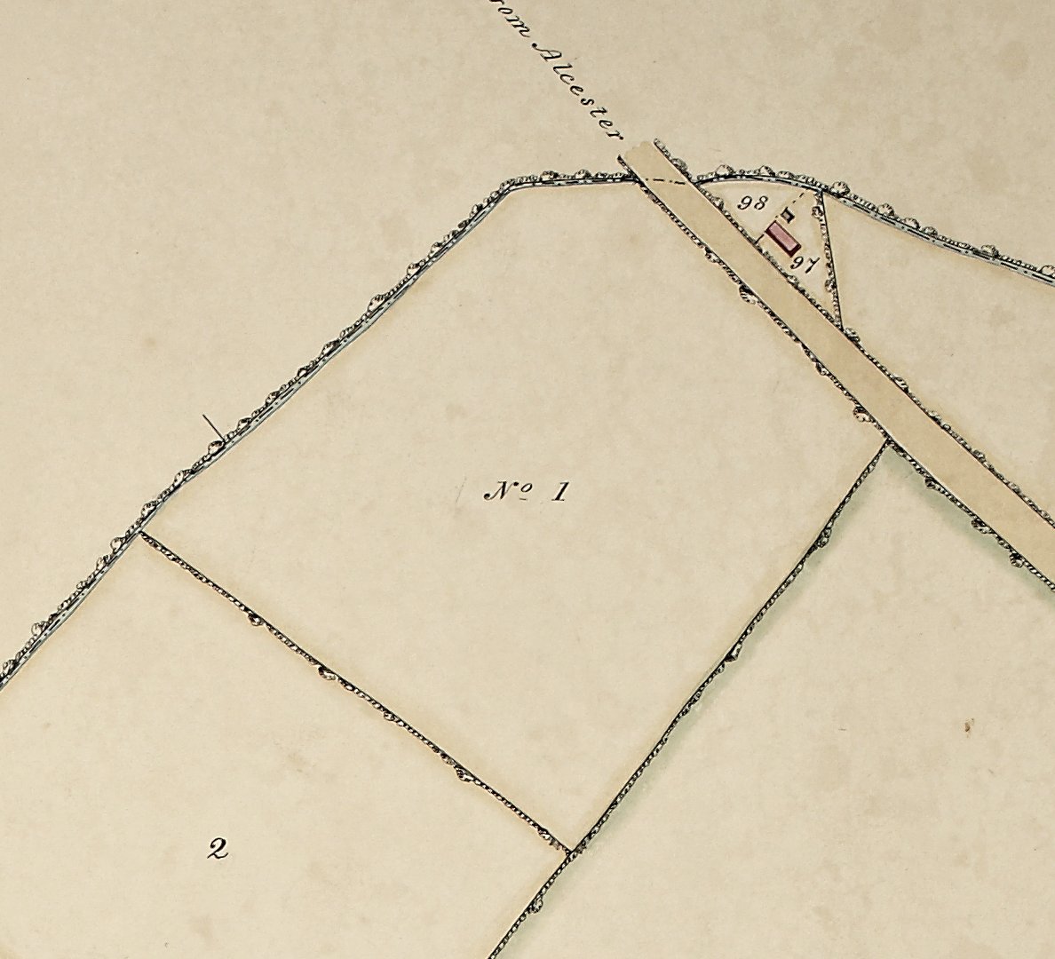
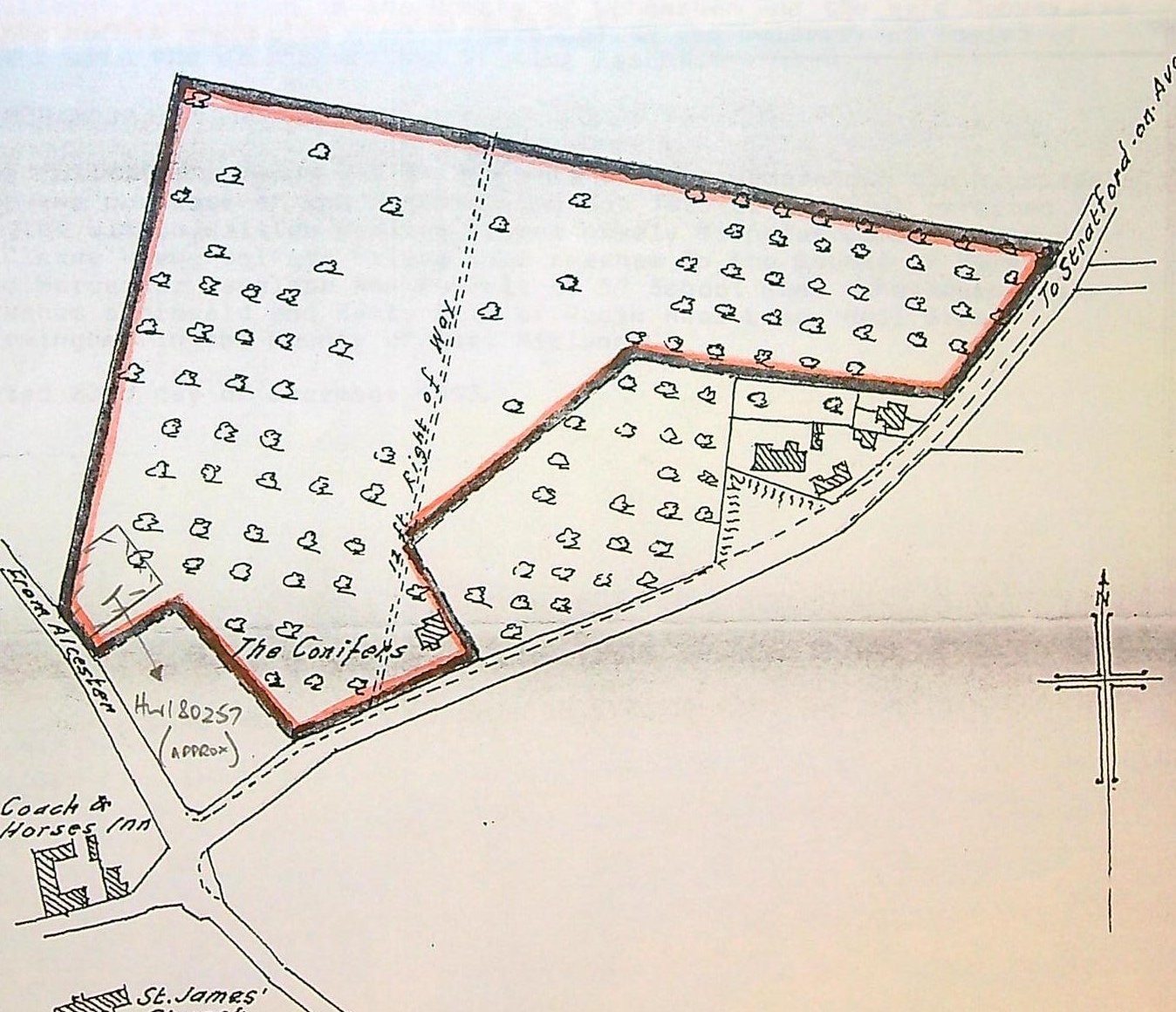
1787: Enclosure Act New Inn Furlong, conjecture by J D Schooling 1965. New Inn Lane Furlong placed here. New Inn Lane is further along the Alcester Road.
1838: a corner field adjacent to the parish boundary ditch and the Evesham/Alcester Road.
1853: a freehold arable field called Washpool, owned by Benjamin Bomford as part of the Harvington Lodge Estate. There is no indication as to why it is called Washpool,
1886: a part of this field was used for building 1 to 6 Brickyard Cottages.
1927: OS map displays a footpath running from the corner of the parish boundary/Evesham/Alcester corner, across the field up to the lodge.
2025: except for the parish boundary all hedgerows have gone.
|
|
| TM 1838: 002: |
OS 1886/1927 18 |
Name where known: Oat Hill |
Location 002: |
|
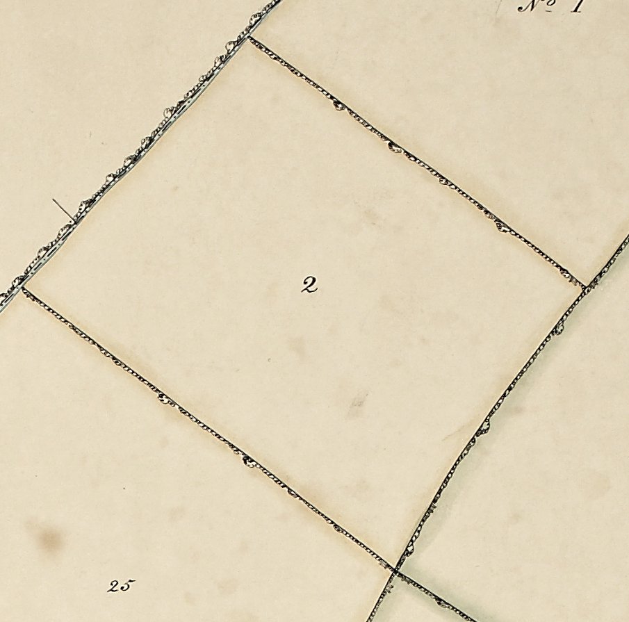
1787:
1838: a field bordering the parish boundary ditch.
1853: a freehold arable field called Oat Hill, owned by Benjamin Bomford as part of the Harvington Lodge Estate.
1886: field combined with field 025.
2025: except for the parish boundary all hedgerows have gone.
|
|
| TM 1838: 003: |
OS 1886/1927: 47 |
name where known: Long Dole |
Location 003: |
|
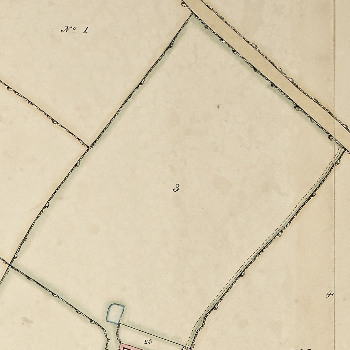
A field stretching from the Evesham/Alcester Road to Harvington Lodge. The track from the road to the lodge runs along the western border and there is a large pool or dip near to the house.
1787:
1853: a leasehold field called Long Dole, set to pasture. Leased by Benjamin Bomford as part of the Harvington Lodge Estate.
1886: depicting orchard. There are two footpaths both starting the corner of the Evesham/Alcester Road and number 6 The Brickyard. Both go to the Lodge but at slightly different angles.
1927: still orchard with only one footpath. The footpath has now (2025) gone. Depicted as orchard.
2025: except for the roadside all hedgerows have gone.
|
|
| TM 1838: 004: |
OS 1886/1927: 51 |
Name where known: Cow Ground |
Location 004: |
|
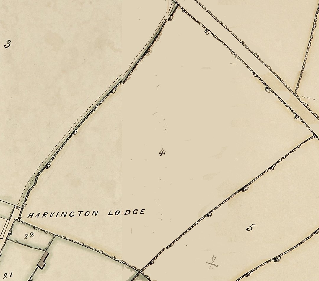
1787:
1838: a field bordering the Evesham/Alcester Road.
1853: a leasehold field called Cow Ground, set to arable. Leased by Benjamin Bomford as part of the Harvington Lodge Estate.
1886:
1927: it is laid down as orchard and merged with fields 5 & 6 have been merged and all are laid down as allotments of orchards.
2025: except for the roadside all hedgerows have gone.
|
|
| TM 1838: 005: |
OS 1886/1927: 57 |
Name where known: |
Location 005: |
|
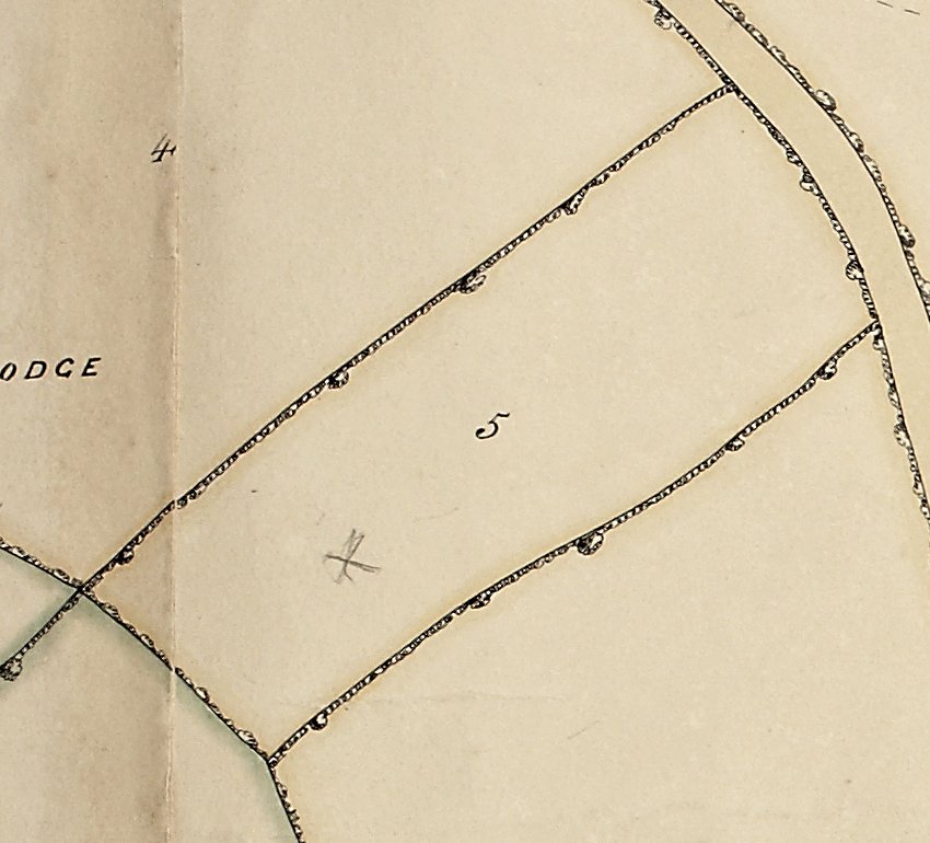
A narrow field bordering the Evesham/Alcester Road.
1787:
1853: leased by Revd Winnington Ingram sometime prior to this date.
1886: fields 5 & 6 have been merged
1927: fields 4, 5 & 6 have been merged and all are laid down as allotments of orchards.
2025: except for the roadside all hedgerows have gone.
|
|
| TM 1838 Tithe Map: 006: |
OS 1886/1927: 57 |
Name where known: Barrow? |
Location 006: |
|
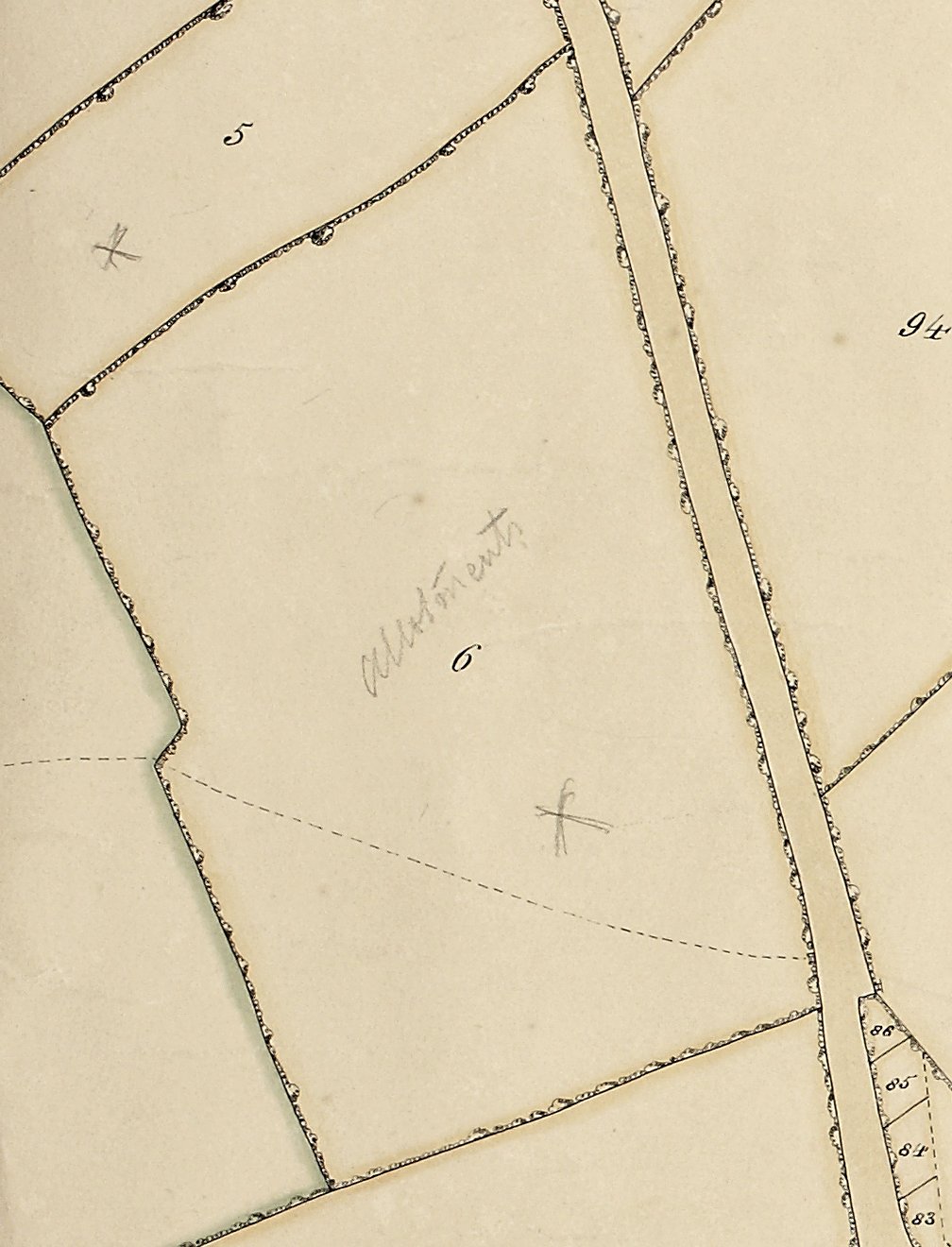
1787:
1838: a field bordering the Evesham/Alcester Road. Allotments in faint pencil has been added to the 1838 tithe map. The track that runs across this field towards Hill Farm is depicted and there is an odd kink as it passes through the hedge line.
1853: leased by Revd Winnington Ingram sometime prior to this date.
1886: fields 5 & 6 have been merged.
1927: fields 4, 5 & 6 have been merged and all are laid down as allotments of orchards. The odd kink noted in 1838 is now a track junction. The footpath existing today branches off at this point and heads north towards Hill Farm The other branch heads east towards the Lodge passing fields 4 & 5 on the right and 20 and 22 on the left ending at junction with track leading to the Lodge.
2025: except for the roadside all hedgerows have gone.
|
|
| TM 1838 Tithe Map: 007: |
OS 1886/1927: 68 |
Name where known: Wellspring Furlong |
Location 007: |
|
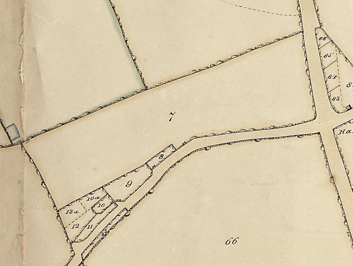
1787: Called Wellspring Furlong (along with number 13), on the Schooling map with same boundaries as in 1838 and owned by Williams.
1838: a field on the corner of the Evesham/Alcester Road and Leys Road.
1886: upper part is in orchard.
1927: all is under orchard.
2025: this field is now lost under housing.
|
|
| TM 1838 Tithe Map: 008: |
OS 1886/1927: 67 |
Name where known: |
Location 008: |
|

1787:
1838: a series of closes taking up a corner alongside Leys Road. These may be small plots but the lie of the land i.e. a hollow, plus evidence from a similar patch on Cress Hill (called the 'Marl-ole'), which suggests marl pits.
1886: under one number now and more detailed, suggesting fruit trees and vegetation.
1927:
2025: this area is now under housing.
|
|
| TM 1838 Tithe Map: 009: |
OS 1886/1927: 67 |
Name where known: |
Location 009: |
|
1787:
1838: a series of closes taking up a corner alongside Leys Road. These may be small plots but the lie of the land i.e. a hollow, plus evidence from a similar patch on Cress Hill (called the 'Marl-ole'), which suggests marl pits.
1886: under one number now and more detailed, suggesting fruit trees and vegetation.
1927:
2025: this area is now under housing.
|
|
| TM 1838 Tithe Map: 010: |
OS 1886/1927: 67 |
Name where known: |
Location 010: |
|
1787:
1838: a series of closes taking up a corner alongside Leys Road. These may be small plots but the lie of the land i.e. a hollow, plus evidence from a similar patch on Cress Hill (called the 'Marl-ole'), which suggests marl pits.
1886: under one number now and more detailed, suggesting fruit trees and vegetation.
1927:
2025: this area is now under housing.
|
|
| TM 1838 Tithe Map: 010a: |
OS 1886/1927: 67 |
Name where known: |
Location 010a: |
|
1787:
1838: a series of closes taking up a corner alongside Leys Road. These may be small plots but the lie of the land i.e. a hollow, plus evidence from a similar patch on Cress Hill (called the 'Marl-ole'), which suggests marl pits.
1886: under one number now and more detailed, suggesting fruit trees and vegetation.
1927:
2025: this area is now under housing.
|
|
| TM 1838 Tithe Map: 011: |
OS 1886/1927: 67 |
Name where known: |
Location 011: |
|
1787:
1838: a series of closes taking up a corner alongside Leys Road. These may be small plots but the lie of the land i.e. a hollow, plus evidence from a similar patch on Cress Hill (called the 'Marl-ole'), which suggests marl pits.
1886: under one number now and more detailed, suggesting fruit trees and vegetation.
1927:
2025: this area is now under housing.
|
|
| TM 1838 Tithe Map: 012: |
OS 1886/1927: 67 |
Name where known: |
Location 012: |
|
1787:
1838: a series of closes taking up a corner alongside Leys Road. These may be small plots but the lie of the land i.e. a hollow, plus evidence from a similar patch on Cress Hill (called the 'Marl-ole'), which suggests marl pits.
1886: under one number now and more detailed, suggesting fruit trees and vegetation.
1927:
2025: this area is now under housing.
|
|
| TM 1838 Tithe Map: 012a: |
OS 1886/1927: 67 |
Name where known: |
Location 012a: |
|
1787:
1838: a series of closes taking up a corner alongside Leys Road. These may be small plots but the lie of the land i.e. a hollow, plus evidence from a similar patch on Cress Hill (called the 'Marl-ole'), which suggests marl pits.
1886: under one number now and more detailed, suggesting fruit trees and vegetation.
1927:
2025: this area is now under housing.
|
|
| TM 1838 Tithe Map: 013: |
OS 1886/1927: 60 |
Name where known: Wellspring Furlong |
Location 013: |
|

1787: Called Wellspring Furlong (along with number 7), on the Schooling map with same boundaries as in 1838 and owned by Williams.
1838: field bordering Leys Road
1886: unchanged.
1920s: this field was developed by the creation of the Brookdale estate.
|
|
| TM 1838 Tithe Map: 014: |
OS 1886/1927: 41/58 |
Name where known: Barrow? |
Location 014: |
|

1787:
1838: there is a square pool in the north west corner. The track noted in field 6 continues across this field to Hill Farm.
1853: leased by Revd Winnington Ingram sometime prior to this date.
1886: merged with field 41. The Track continues through the farmyard but before it does a branch ran eastwards in a straight line passed fields 16,17,18 & 19, at the end of which it sharp left and continued northwards passed fields 24,27,33 on the right to eventually rejoin original track from and through Hill Farm.
This or neighbouring fields 6 or 29 were known colloquially as 'Barra' the local term for Barrow. It is almost certain this refers to a lost prehistoric monument in the close vicinity possibly near or close to Hill Farm. The situation is favourable being on commanding position with gentle slopes to the south and west.
|
|
| TM 1838 Tithe Map: 015: |
OS 1886/1927: 59 |
Name where known: Hill Farm |
Location 015: |
|

1787:
1838: depicts Hill Farm in its close in pink. To the north on the other side of the track is a yard with buildings on three sides.
1886: Hill Farm is depicted in fine detail with trees in its garden. Under 'Buildings', there is photograph of what it once looked like.
Neighbouring fields 6, 14 or 29 were known colloquially as 'Barra' the local term for Barrow. It is almost certain this refers to a lost prehistoric monument in the close vicinity possibly near or close to Hill Farm. The situation is favourable being on commanding position with gentle slopes to the south and west.
Hill Farm is now a very sad ruin surrounded by vegetation. On the other side of the track are remains of the farm buildings.
|
|
| TM 1838 Tithe Map: 016: |
OS 1886/1927: 39 |
name where known: Hill Farm outbuildings |
Location 016: |
|
1787:
1838: depicts Hill Farm and its farm buildings. To the south on the other side of the track is Hill Farm. By 1886 the close to the north is now part of the farmyard.
1886: 16 & 17 are now merged. The farm and its outbuildings are depicted in fine. There also appears to be a square pool of dip near the track.
The farm buildings have all but disappeared under vegetation and very little remains. On the other side of the track are remains of the farm house.
|
|
| TM 1838 Tithe Map: 017: |
OS 1886/1927: 40 |
Name where known: Hill Farm |
Location 017: |
|
1787:
1838: a close belonging to Hill Farm.
1886: the close is now merged with farm buildings (16).
The farm buildings have all but disappeared under vegetation and very little remains.
|
|
| TM 1838 Tithe Map: 018: |
OS 1886/1927: 40 |
Name where knowm: |
Location 018: |
|
1787:
1838: depicts a close. Note the small shed in the corner.
1886: laid down to orchard. There is also a track leading from Hill Farm to the Lodge.
2025: merged with the surrounding terrain, no boundaries remain.
|
|
| TM 1838 Tithe Map: 019: |
OS 1886/1927: 42 |
Long Orchard: |
Location 019: |
|

1787:
1838: long narrow field adjacent to Harvington Lodge.
1853: a leasehold field called Long Orchard, set to pasture. Leased by Benjamin Bomford as part of the Harvington Lodge Estate.
1886: laid down to orchard with long narrow building at the far end.
2025: merged with the surrounding terrain, no boundaries remain.
|
|
| TM 1838 Tithe Map: 020: |
OS 1886/1927: 42 |
Name where known: Rams Close |
Location 020: |
|
1787:
1838: a small field with a building on its eastern side.
1853: a leasehold field called Rams House, set to pasture. Leased by Benjamin Bomford as part of the Harvington Lodge Estate.
1886: merged with field 21. Laid down to orchard. A small building is depicted along with a possible pool.
2025: merged with the surrounding terrain, on boundaries remain.
|
|
| TM 1838 Tithe Map: 021: |
OS 1886/1927: 42 |
Name where known: Cow Ground |
Location 021: |
|
1787:
1838: a small field or large close.
1853: a leasehold field called Little Orchard, set to pasture. Leased by Benjamin Bomford as part of the Harvington Lodge Estate.
1886: merged with field 20. Laid down to orchard. A possible pool adjacent to field 22.
2025: merged with the surrounding terrain, no boundaries remain. Laid down to farmyard and buildings etc.
|
|
| TM 1838 Tithe Map: 022: |
OS 1886/1927: 43 |
Name where known: Harvington Lodge Garden |
Location 022: |
|
1787:
1838: a close to the west of the Lodge and across the track/driveway.
1853: part of the grounds to Harvington Lodge, called 'garden'. Leased of owned by Benjamin Bomford as part of the Harvington Lodge Estate.
1886: this shews as orchard.
2025: no boundaries remain and derelict. |
|
| TM 1838 Tithe Map: 023: |
OS 1886/1927: 44/45 |
Name where known: Harvington Hill/Lodge |
Location 023: |
|
1787:
1853: with 25 - Harvington Lodge and its cottage & outbuildings, Leasow Lane Coppice. Leased or owned by Benjamin Bomford as the Harvington Lodge Estate.
1886: depicts the farmstead with more detail but with some significant changes. The house is larger and appears to replace a smaller structure. There is also a problem in that the censuses indicate two residences - Harvington Lodge - The Hill etc. See under buildings.
|
|
| TM 1838 Tithe Map: 024: |
OS 1886/1927: 46 |
Name where known: Upper Buck Hill |
Location 024: |
|

1787:
1838: a square field to the east of Harvington Lodge. There is a pool in the north-east corner.
1853: a leasehold field called Upper Buck Hill, set to arable. Leased by Benjamin Bomford as part of the Harvington Lodge Estate. The hill is the slope up to the Lodge.
1886: the pool appears to have disappeared but is a track running along its western border.
All field boundaries are gone - no hedgerows.
|
|
| TM 1838 Tithe Map: 025: |
OS 1886/1927: 18 |
Name where known: Lower Buck Hill |
Location 025: |
|

1787:
1838: a field bordering the parish boundary ditch.
1853: A leasehold field called Lower Buck Hill, set to arable, leased by Benjamin Bomford as part of the Harvington Lodge Estate. The hill is the slope up to the Lodge.
1886: by this date it had been merged with fields 26, 27 & 33.
All field boundaries, except parish boundary are gone - no hedgerows.
|
|
| TM 1838 Tithe Map: 026: |
OS 1886/1927: 18 |
Name where known: Behind Buck Hill and Leasow |
Location 026: |
|

1787: Enclosure Act.
1838: a field bordering the parish boundary ditch.
1853: A leasehold field called Behind Buck Hill and Leasow, set to arable. Probably once two fields as part of the Harvington Lodge Estate.
1886: by this date it was merged with fields 25, 27 & 33.
All field boundaries, except parish boundary are gone - no hedgerows.
|
|
| TM 1838 Tithe Map: 027: |
OS 1886/1927: 18 |
Name where known: Mill Bank |
Location 027: |
|

1787:
1838: a field with hut in corner.
1853: a leasehold field called Mill Bank, set to arable. Leased by Benjamin Bomford as part of the Harvington Lodge Estate. The name and position suggests a windmill. In the deeds of Harvington Lodge there is mention of a cidar mill
1886: by this date it was merged with fields 25, 26 & 33.
All field boundaries are gone - no hedgerows.
|
|
| TM 1838 Tithe Map: 028: |
OS 1886/1927: 36/37 |
Name where known: |
Location 028: |
|

1787:
1838: a field with the track/footpath running through it from fields 29 to 32. The odd shape to this field indicates a hark back to the open field system.
1853: leased by REV A W Ingram sometime prior to this date.
1886: by this date the boundaries of this field had changed considerably. Just to the south of this footpath/track, maybe faintly represented by a pencil-drawn circle, is a feature numbered 36 on the 1886 OS map, it appears to be a pool surrounded by trees.
All field boundaries, except parish boundary are gone - no hedgerows except on the western side where there is a ditch and spring course dividing it from the Blakenhurst Estate.
|
|
| TM 1838 Tithe Map: 029: |
OS 1886/1927: 36/37 |
Name where known: |
Location 029: |
|

1787:
1838: a large field with the track/footpath running through it from Hill Farm to field 28.
1853: leased by Revd H A Pye sometime prior to this date.
1886: Unchanged from 1838.
All field boundaries, except parish boundary are gone - no hedgerows.
|
|
| TM 1838 Tithe Map: 030: |
OS 1886/1927: 61 |
Name where known: |
Location 030: |
|

1787:
1838: a large field bordering Leys Road. Written in pencil is 'allots' (allotments).
1853: leased by Revd H A Pye sometime prior to this date.
1886: Unchanged from 1838.
This field was developed in the 1960s to create the Blakenhurst Estate. There was talk of the discovery of a small Roman foot in this area but no investigation took place.
|
|
| TM 1838 Tithe Map: 031: |
OS 1886/1927: 35 |
Name where known: |
Location 031: |
|

1787:
1838: a field extending from the Leys Road back to the footpath mentioned before.
1853: leased by Revd H A Pye sometime prior to this date.
1886: Unchanged in 1835.
2025: this field was utilised to create a community orchard and large pool. Prior archaeological investigations discovered Roman-British remains which extended south into field 30.
|
|
| TM 1838 Tithe Map: 032: |
OS 1886/1927: 37 |
Name known: Edmund's Piece |
Location 032: |
|
1787:
1853: a leasehold field called Edmund's Piece, set to pasture. Leased by Benjamin Bomford as part of the Harvington Lodge Estate.
1838: an oddly-shaped field or patch which is hard to explain. There is a hut in its south east corner and the footpath/track on its western edge.
1886: by 1886 it is amalgamated with field 28, has its southern portion and the shed in 1838 has become two buildings and a close, perhaps hovels. Its northern part is depicted as trees or orchard.
2025 all boundaries have gone.
|
|
| TM 1838 Tithe Map: 033: |
OS 1886/1927: 18 |
Name where known: First Leasowe |
Location 033: |
|

1787:
1853: a leasehold field called First Leasow, set to arable. Leased by Benjamin Bomford as part of the Harvington Lodge Estate.
1838: a square field with no distinguishing features.
1886: by 1886 it had been merged with fields 25,26 &27.
2025: all boundaries have gone.
|
|
| TM 1838 Tithe Map: 034: |
OS 1886/1927: 17 |
Name where known: New Meadow |
Location 034: |
|

1787:
1853: a leasehold field called New Meadow, formerly pasture now arable. Leased by Benjamin Bomford as part of the Harvington Lodge Estate.
Possessed by the Marshalls at Harvington Lodge.
1838: a small field against the parish boundary ditch. There is a hut on its southern edge.
1886: by 1886 it is merged with fields 35 & 36 & 44.
2025 all boundaries have gone.
|
|
| TM 1838 Tithe Map: 035: |
OS 1886/1927: 17 |
Name where known: Leasow Lane Coppice |
Location 035: |
|

1787:
1853: a leasehold field called Leasow Lane Coppice (a the bottom of Leasow Lane), set to wood. Leased by Benjamin Bomford as part of the Harvington Lodge Estate.
1838: an oddly-shaped copse on the parish boundary ditch. There appears to be either a track (No.44a) that leads to this copse from the west, maybe for access?
1886: by 1886 the copse appears to been reduced.
|
|
| TM 1838 Tithe Map: 036: |
OS 1886/1927: 17 |
Name where known: Far Leasow |
Location 036: |
|

1787:
1853: a leasehold field called Far Leasow, set to pasture. Leased by Benjamin Bomford as part of the Harvington Lodge Estate.
1838: a large field with the footpath continuing from field 28 & 32.
1886: merged with 34 and part of 35.
|
|
| TM 1838 Tithe Map: 037: |
OS 1886/1927: 17/36 |
Name where known: |
Location 037: |
|

1787:
1838: a field bordering Leys Road and extending back to the footpath/track.
1886: the field has now been extended to the north to include wood or scrub numbered 38 & 39.
2025: all boundaries plus the pool have gone.
|
|
| TM 1838 Tithe Map: 038: |
OS 1886/1927: 17/36 |
Name where known: |
Location 038: |
|

1787:
1838: a field bordering the Leys Road that, along with No.39, appears to be woodland.
1886: the field has now been extended to the north to include wood or scrub numbered 38 & 39.
2025: all boundaries plus the pool have gone.
|
|
| TM 1838 Tithe Map: 039: |
OS 1886/1927: 17 |
Name where known: Coppice |
Location 039: |
|

1787:
1838: a patch of woodland bordering the Leys Road that, along with No.38.
1870 document of possession in the Bank House deeds (originally possessed by the Grange), gives the name for the field as 'Coppice'.
1886: it is believed that the woodland was cleared and merged with fields 37 and 38.
2025 somewhere in this vicinity there is now a house fronting onto Leys Road.
|
|
| TM 1838 Tithe Map: 040: |
OS 1886/1927: 17 |
Name where known: The Leashow |
Location 040: |
|

1777:
The Leasow, a field bordering The Leys.
1838: a small field bordering the Leys Road that was merged along with fields 39,38 & 37.
1870 document of possession in the Bank House deeds (originally possessed by the Grange), gives the name for the field as 'The Leashow'.
1886: the field has now been extend to the north to include wood or scrub numbered 38 & 39.
2025: all boundaries have gone.
|
|
| TM 1838 Tithe Map: 041: |
OS 1886/1927: 25 |
Name where known: Buckhill |
Location 041: |
|

1787:
1838: a field bordering the Leys Road that extends back to the footpath/track. There are two buildings adjacent to the road.
1853: leased by Miss Edwin sometime prior to this date.
1886: now shewing a pond on the upper side of the buildings creating a yard.
2025: all boundaries plus the buildings have gone but an irregular pond with surrounding trees still survives.
|
|
| TM 1838 Tithe Map: 042: |
OS 1886/1927: 23 |
Name where known: |
Location 042: |
|

1787:
1838: a long thin belt of trees extending from the Ley Road at the point where it turns left and where the Wooden House is situated.
1886: This belt of trees is highlighted in more detail in 1886.
2025: all boundaries plus the belt of trees have gone leaving a track which eventually joins the footpath/track and viers to the south heading for Hill Farm. On the northern side the land slopes down to a belt of trees.
|
|
| TM 1838 Tithe Map: 043: |
OS 1886/1927: 22 |
Name where known: |
Location 043: |
|

1787:
1838: a field extending from the Wooden House to the footpath/track, sloping north to a track. While Leys Road viers off to the west at this point the alignment of Leys Road continues as a footpath.
1853: leased by Mr John Marshall sometime prior to this date.
1886: unchanged in 1886.
2025: boundaries on the south and east side are gone but the field is still demarcated by footpaths, tracks and belt of trees.
|
|
| TM 1838 Tithe Map: 044: |
OS 1886/1927: 24 |
Name where known: |
Location 044: |
|

1787:
1838: a triangular piece of land ending in a copse (35), with the footpath/track on its western border.
1886: some in 1886.
2025: all boundaries are gone.
|
|
| TM 1838 Tithe Map: 044a: |
OS 1886/1927: 23 |
Name where known: Leasow Lane |
Location 044a: |
|

This has been identified as once a track called Leasow Lane, see the Ramell Terrier and Harvington Lodge.
1787:
1838: An unusual feature. It is what appears on the map as a substantial track leading from a footpath, with a gateway, to a copse on the parish boundary.
1886: unchanged.
2025: it is now a broad band of trees and scrub in a natural fullow in the landscape.
|
|
| TM 1838 Tithe Map: 045: |
OS 1886/1927: 14 |
Name where known: The Leasows |
Location 045: |
|

1777: Believed to be the Leasows on Ramell's Terrier, note Leasow Lane.
1787:
1838: a field on the corner of the parish with the parish boundary bank on the north and the parish boundary ditch on the east side. Now merged with 46.
1853: leased by Mr W H Marshall sometime prior to this date.
1886:
|
|
| TM 1838 Tithe Map: 046: |
OS 1886/1927: 14 |
Name where known: Buckhill Field |
Location 046: |
|

1777: May be called Buck hill Field as being adjacent to The Leasows, see Ramell's Terrier. Ifen the two Buckhill Fields, this one and one to the east of the Lodge.
1787:
1838: a field adjacent to the northern boundary bank with the footpath passing through it and passing out of the village on its way up the hill to Atch Lench.
1853: leased by Mr W H Marshall sometime prior to this date.
1886: now merged with field 45.
2025: although the boundary has lost its trees it still displays a considerable bank. It has been merged with field 47 on its western side but retains its southern boundary of trees.
|
|
| TM 1838 Tithe Map: 047: |
OS 1886/1927: 15 |
Name where known: |
Location 047: |
|

1787:
1886: This belt of trees is highlighted in more detail in 1886.
2025:
|
|
| TM 1838 Tithe Map: 048: |
OS 1886/1927: 20 |
Name where known: The Wooden House/Woodbine Cottage |
Location 048: |
|

1787:
1838: depicting the farmstead: Wooden House and outbuilding.
1886: house and pool in more detail.
2025: in recent years the Wooden House and adjacent Victorian Woodbine Cottage have been replaced by a house called 'Whistlewinds'.
|
|
| TM 1838 Tithe Map: 049: |
OS 1886/1927: 19 |
Name where known: The Leys/Powson's Leasow |
Location 049: |
|

1777: a small partof this field may have contained Pawson's Leasow, owned by Ramell.
1787: Called The Leys along with fields 50, 51, 52, 53, 54, 55 on the Schooling map with same boundaries as in 1838. Owned by Chamberlain.
1838: a field bordered by Leys Road, the parish boundary bank and fields 47 & 43. The field has a footpath, the extension of Leys Road, that runs up the hill towards Atch Lench. Half way up its eastern side is what appears to be a track/treeline that continues eastwards to a copse and east boundary of the parish.
1886: This track or belt of trees is highlighted in more detail in 1886 and is still there today.
2025: The bank of the parish boundary still survives but without hedge or trees. Throughout this area there has been a loss of hedge rows and trees.
|
|
| TM 1838 Tithe Map: 050: |
OS 1886/1927: 30 |
Name where known: The Leys |
Location 050: |
|

1787: Called The Leys along with fields 49, 51, 52, 53, 54, 55 on the Schooling map with same boundaries as in 1838. Owned by Chamberlain.
1838: a field bordered by the parish boundary bank and Leys Road except and aged ash tree on the roadside.
1886:
2025: all boundaries have been removed including all signs of the parish boundary.
|
|
| TM 1838 Tithe Map: 051: |
OS 1886/1927: 31 |
Name where known: The Leys |
Location 051: |
|

1787: Called The Leys along with fields 49, 50, 52, 53, 54, 55 on the Schooling map with same boundaries as in 1838. Owned by Chamberlain.
1838: a corner field bordered by the parish boundary bank and the parish boundary/Harvington Brook.
1886:
2025: all boundaries except the parish boundary/Harvington Brook on the western side have been removed.
|
|
| TM 1838 Tithe Map: 052: |
OS 1886/1927: 32 |
Name where known: The Leys |
Location 052: |
|

1787: Called The Leys along with fields 49, 50, 51, 53, 54, 55 on the Schooling map with same boundaries as in 1838 but joined with 54. Owned by Williams.
1838: a field bordered by the parish boundary to the west.
1886:
2025: all boundaries except the parish boundary/Harvington Brook on the western side have been removed.
|
|
| TM 1838 Tithe Map: 053: |
OS 1886/1927: 29 |
Name where known: The Leys |
Location 053: |
|

1787: Called The Leys along with fields 49, 50, 51, 52, 54, 55 on the Schooling map with same boundaries as in 1838. Owned by Elizabeth & Thomas Walford Marshall.
1838: a field bordered by leys Road.
1886:
2025: all boundaries except by Keeper Cottage on the south-east corner have been removed.
|
|
| TM 1838 Tithe Map: 054: |
OS 1886/1927: 27/28 |
Name where known: The Leys |
Location 054: |
|

1787: Called The Leys along with fields 49, 50, 51, 52, 53, 55 on the Schooling map with the same boundaries as in 1838 but joined with 52. Owned by Williams.
1838: a field bordering Leys Road with the cottage now called Keepers Cottage.
1886: the same but depicted in more detail.
2025:
|
|
| TM 1838 Tithe Map: 055: |
OS 1886/1927: 33 |
Name where known: The Leys |
Location 055: |
|

1787: Called The Leys along with fields 49, 51, 52, 53, 54 on the Schooling map with same boundaries as in 1838. Owned by the Rector.
1838: a long field bordering Leys Road on its east end and the parish boundary/Harvington Brook on its west end. There is a kink on its southern side which may indicate that the field was once divided at this point.
1886: the same but depicted in more detail.
2025:
|
|
| TM 1838 Tithe Map: 056: |
OS 1886/1927: 34 |
Name where known: Far Lays |
Location 056: |
|

1787: part of a large open field covering fields with a number of named plots on the Schooling map. Owned by Chamberlain.
1838: a field bordering the parish boundary/Harvington Brook.
1870 document of possession in the Bank House deeds (originally possessed by the Grange), gives the name for the field as 'Far Leys'.
1886: now merged with fields 57 & 58.
2025:
|
|
| TM 1838 Tithe Map: 057: |
OS 1886/1927: 34 |
Name where known: The Leys |
Location 057: |
|

1787: Called The Leys along with fields 49, 51, 52, 53, 54 on the Schooling map with same boundaries as in 1838. Owned by Godfrey.
1838: a field bordering Leys Road with a track leading from Leys Road to a sand pit.
1886: now merged with fields 56 & 58.
2025:
|
|
| TM 1838 Tithe Map: 058: |
OS 1886/1927: 34 |
Name where known: Big Leys |
Location 058: |
|

1787: part of a large open field with a number of named plots on the Schooling map. Owned by Chamberlain.
1787: part of a large open field with a number of named plots on the Schooling map. Owned by Chamberlain.
1838: an L-shaped field bordering the parish boundary/Harvington Brook.
1870 document of possession in the Bank House deeds (originally possessed by the Grange), gives the name for the field as 'Big Leys'.
1886: now merged with fields 56 & 57.
2025:
|
|
| TM 1838 Tithe Map: 059: |
OS 1886/1927: 34 |
Name where known: The Ten Acres |
Location 059: |
|

1787: part of a large open field with a number of named plots on the Schooling map. Owned by Chamberlain.
1838: a field bordering Leys Road.
1870 document of possession in the Bank House deeds (originally possessed by the Grange), gives the name for the field as 'The Ten Acres'.
1886: now merged with fields 56,57,58.
2025:
|
|
| TM 1838 Tithe Map: 060: |
OS 1886/1927: 62 |
Name where known: Old Turf Ground |
Location 060: |
|

1787: part of a large open field with a number of named plots on the Schooling map. Owned by Chamberlain.
1838: a field bordering Leys Road with tract leading from Leys Road to Leys Barn.
1870 document of possession in the Bank House deeds (originally possessed by the Grange), gives the name for the field as 'Old Turf Ground'.
1886: now merged with field 62.
2025:
|
|
| TM 1838 Tithe Map: 061: |
OS 1886/1927: 62 |
Name where known: Leys Barn |
Location 061: |
|

1787:
1838: a collection of barns with tracks leading east Leys Road and south to the Evesham/Alcester Road.
1870 document of possession in the Bank House deeds (originally possessed by the Grange), gives the name for the field as 'Barn Rickyard'.
1886: now with more detail including name of 'Leys Barn'.
2025: now a habitation etc.
|
|
| TM 1838 Tithe Map: 062: |
OS 1886/1927: 62 |
Name where known: Barn Ground |
Location 062: |
|

1787: part of a large open field with a number of named plots on the Schooling map. Owned by Chamberlain.
1838: a field bordering the parish boundary/Harvington Brook with a tract leading from Ley Barn to the Evesham/Alcester Road.
1870 document of possession in the Bank House deeds (originally possessed by the Grange), gives the name for the field as 'Barn Ground'.
1886:
2025: now merged with field 60.
|
|
| TM 1838 Tithe Map: 063: |
OS 1886/1927: 64 |
Name where known: Short Lands |
Location 063: |
|

1787: part of a large open field with a number of named plots on the Schooling map. Owned by Chamberlain.
1838: a field bordering Leys Road.
1870 document of possession in the Bank House deeds (originally possessed by the Grange), gives the name for the field as 'Short Lands'.
1886: the northern hedge line with field 64 has been altered.
2025: this field is now lost to development.
|
|
| TM 1838 Tithe Map: 063a: |
OS 1886/1927: 64 |
Name where known: Upper Norbrook |
Location 063a: |
|

1787: part of a large open field with a number of named plots on the Schooling map. Owned by Chamberlain.
1838: a field bordering the parish boundary/Harvington Brook.
1870 document of possession in the Bank House deeds (originally possessed by the Grange), gives the name for the field as 'Upper Norbrook'.
1886:
2025:
|
|
| TM 1838 Tithe Map: 064: |
OS 1886/1927: 64 |
Name where known: Banlands |
Location 064: |
|

1787: Called Banlands Furlong (along with Shorter Furlong, number 67), on the Schooling map with same boundaries as in 1838 and owned by Pearce.
1838: an oddly-shaped field suggesting old divisions, bordering Leys Road. In a corner on its southern there is a small pool which it shares with field 67.
1886: no sign of pool and the northern hedge line with field 63 has been altered.
1886:
2025: this field is now lost to development,
|
|
| TM 1838 Tithe Map: 065: |
OS 1886/1927: 64 |
Name where known: |
Location 065: |
|

1787:
1838: a long-thin strip of land bordering the Leys Road.
1886: this strip is incorporated into field 66.
2025:
|
|
| TM 1838 Tithe Map: 066: |
OS 1886/1927: 66 |
Name where known: Brack Furlong. |
Location 066: |
|

1787: Called Brack Furlong on the Schooling map with same boundaries as in 1838 and owned by Ramell.
1838: a field bordering the Evesham/Alcester Road on its south and Leys Road on its east sides. In its north-east corner there is a small pool which it shares with field 64.
1886: no sign of pool.
2025: this field is now lost to development.
|
|
| TM 1838 Tithe Map: 067: |
OS 1886/1927: 65 |
Name where known: Shorter Furlong |
Location 067: |
|

1787: Called Shorter Furlong (along with Banlands Furlong, number 64), on the Schooling map with same boundaries as in 1838 and owned by Pearce.
1838: a field bordering the Evesham/Alvester Road.
2025:
|
|
| TM 1838 Tithe Map: 068: |
OS 1886/1927: 108 |
Name where known: First Norbrook |
Location 068: |
|

1787: part of a large open field with a number of named plots on the Schooling map. Owned by Chamberlain.
1838: field bordering on the on the west side the parish boundary/Harvington Brook.
1870 document of possession in the Bank House deeds (originally possessed by the Grange), gives the name for the field as 'First Norbrook'.
1886: by this date fields 62 (part), 63a, 68, 69 have been merged into one large field.
2025:
|
|
| TM 1838 Tithe Map: 069: |
OS 1886/1927: 108 |
Name where known: Arch Ground |
Location 069: |
|

1787: part of a large open field with a number of named plots on the Schooling map. Owned by Chamberlain.
1787: part of a large open field with a number of named plots on the Schooling map. Owned by Chamberlain.
1838: field bordering on the south side the Evesham/Alcester Road and on the west by the parish boundary/Harvington Brook.
1870 document of possession in the Bank House deeds (originally possessed by the Grange), gives the name for the field as 'Arch Ground'.
1886: by this date fields 62 (part), 63a, 68, 69 have been merged into one large field.
2025:
|
|
| TM 1838 Tithe Map: 070: |
OS 1886/1927: 109 |
Name where known: |
Location 070: |
|

1787:
1838: a small copse bordering the Evesham/Alcester Road and the parish boundary/Harvington Brook.
1886:
2025: still there.
|
|
| TM 1838 Tithe Map: 071: |
OS 1886/1927: 109 |
Name where known: Brook Furlong |
Location 071: |
|

1787:
1838: a field bordered by the south side of the Leys Road and the parish boundary/Harvington Brook. There is a footpath running along its east hedge line.
1870 document of possession in the Bank House deeds (originally possessed by the Grange), gives the name for the field as 'Brook Furlong'.
1886:
2025: the footpath still exists and exits into the Evesham/Alcester Road. Ellenden Farm shop is built upon part of this field.
|
|
| TM 1838 Tithe Map: 072: |
OS 1886/1927: 107 |
Name where known: Beckstone |
Location 072: |
|

1787:
1838: a field with a small section bordering the parish boundary/Harvington Brook. There is a footpath running along its eastern and southern hedge line.
1870 document of possession in the Bank House deeds (originally possessed by the Grange), gives the name for the field as 'Beckstone'.
1886:
2025: The footpath is still present and well used.
|
|
| TM 1838 Tithe Map: 073: |
OS 1886/1927: 107 |
Name where known: Pool Close |
Location 073: |
|

1787:
1838: a field bordering the parish boundary/Harvington Brook. Adjacent is a large pool (74).
1870 document of possession in the Bank House deeds (originally possessed by the Grange), gives the name for the field as 'Pool Close'.
1886:
2025:
|
|
| TM 1838 Tithe Map: 074: |
OS 1886/1927: 146 |
Name where known: Fish Pool & Spinney |
Location 074: |
|

1787:
1838: A large pool.
1870 document of possession in the Bank House deeds (originally possessed by the Grange), gives the name for the field as 'Fish Pool & Spinney'.
1884:
2025: still there.
|
|
| TM 1838 Tithe Map: 075: |
OS 1886/1927: 71 |
Name where known: Crag Tree Leys |
Location 075: |
|

1787:
1838: a field laid down to orchard. A footpath runs along its southern border but splitting half way along, one continuing and one branching off to the north.
1870 document of possession in the Bank House deeds (originally possessed by the Grange), gives the name for the field as 'Crag Tree Leys'.
1886:
2025: still a field.
|
|
| TM 1838 Tithe Map: 076: |
OS 1886/1927: 71 |
Name where known: Croft Furlong & Water Furrows |
Location 076: |
|

1787: Called Croft Furlong and Water Furrows, on the Schooling map with same boundaries as in 1838 and owned by Pearce.
1838: a large L-shaped field bordering the Leys Road on its northern side. There are several footpaths here with a junction at the cusp of the angle. From the junction a footpath (still in existence) runs eastwards to Village Street. It turns at the junction to run southward to Hughes Lane. There is another footpath that ran from Hughes Lane westwards towards the front of the Grange,
1886:
2025: still partly a field. The southern western section is now under Hughes Close and the footpath is lost.
|
|
| TM 1838 Tithe Map: 077: |
OS 1886/1927: 75 |
Name where known: |
Location 077: |
|

1787: Presumed to be part of the Ragley Furlong on the Schooling map owned by the Rector.
1838: a close bordering Hughes Lane on western side.
1886: an orchard. A cherry orchard according to the deeds of adjacent Cedar Lodge.
2025: Developed.
|
|
| TM 1838 Tithe Map: 078: |
OS 1886/1927: 83 |
Name where known: The Wheelwrights House |
Location 078: |
|

1787:
1838: the Wheelwrights House
1886: Burnt down and replaced by Cedar Lodge.
2025:
|
|
| TM 1838 Tithe Map: 079: |
OS 1886/1927: 76 |
Name where known: |
Location 079: |
|

1787:
1838: a tiny strip of land adjacent to Village Street.
1886: trees or orchard, part of field 80.
2025:
|
|
| TM 1838 Tithe Map: 080: |
OS 1886/1927: 76 |
Name where known: Ragley Furlong |
Location 080: |
|

1787: Called Ragley Furlong on the Schooling map with same boundaries as in 1838 and owned by the Rector.
1838: field bordering Village Street.
1886: laid down to orchard.
2025: housing.
|
|
| TM 1838 Tithe Map: 081: |
OS 1886/1927: 70 |
Name where known: Crooked Furlong |
Location 081: |
|

1787: Called Brack Furlong on the Schooling map with same boundaries as in 1838 and owned by Ramell.
1838: field on the corner of Village Street and the Evesham/Alcester Road. a footpath crosses it from field 76 and ending in Village Street.
1886:
2025: 20/21st century housing development.
|
|
| TM 1838 Tithe Map: 082: |
OS 1886/1927: 69 |
Name where known: The Golden Cross Inn |
Location 082-6: |
|

1787:
1838: the Golden Cross Inn in Village Street just back from the corner of Village Street and the Evesham/Alcester Road.
1886: depicted in more detail with garden behind.
2025: still the Golden Cross.
|
|
| TM 1838 Tithe Map: 083: |
OS 1886/1927: 69 |
Name where known: Rose Villas/Porter's Elm |
Location 082-6: |
|
1787:
1838: four closes stretching from the corner of Village Street along the Evesham/Alvester Road. The plot on the corner once had a tree called Porter's Elm.
1886: by this time just off the corner, 'Rose Villas' have been built.
2025: Rose Villas.
|
|
| TM 1838 Tithe Map: 084: |
OS 1886/1927: 69 |
Name where known: |
Location 082-6: |
|
1787:
1838: a small close.
1886: orchard
2027: occupied by Greengates.
2025: now occupied by Greengates.
|
|
| TM 1838 Tithe Map: 085: |
OS 1886/1927: 69 |
Name where known: |
Location 082-6: |
|
1787:
1838: a small close.
1886: orchard
2025: was a garage but now occupied new housing.
|
|
| TM 1838 Tithe Map: 086: |
OS 1886/1927: 69 |
Name where known: |
Location 082-6: |
|
1787:
1838: a small close.
1886: orchard
2025: now occupied by West Holme.
2025: occupied by West Holme.
|
|
| TM 1838 Tithe Map: 087: |
OS 1886/1927: 69 |
Name where known: |
Location 087: |
|

1787: part of Makingway Furlong is mentioned on the Schooling map on an area owned by Ann Hawkes.
1838: a field bordering both Village Street and the Evesham/Alcester Road. With a footpath running from Village Street to the Alcester Road.
1886: laid down to orchard with Fairview Cottages now occupying the north-western corner.
2025: lost to housing - Myatts Close.
|
|
| TM 1838 Tithe Map: 088: |
OS 1886/1927: 69 |
Name where known: |
Location 088: |
|

1787: part of Milkingway Furlong on Schooling's map associated with an owner called William Tovey.
1838: a field with a corner bordering Village Street.
1886: merged with field 87, however the hedge line once between fields 87 & 88 has turned into what appears to be a track with two small buildings either side of the track at its junction with Village Street.
2025: Very possibly the tract in 1886 is on alignment with Greenacres Lane.
|
|
| TM 1838 Tithe Map: 089: |
OS 1886/1927: 78 |
Name where known: |
Location 089: |
|

1787: mentioned on the Schooling map as a field owned by Holebrook.
1838: a triangular field bordering Village Street. there is a short footpath on its southern border connecting Village Street and Green Street.
1886: laid down to orchard with a small hut adjacent to the road.
2025: lost to housing, mostly in Edwardian times.
|
|
| TM 1838 Tithe Map: 090: |
OS 1886/1927: 83 |
Name where known: The Hop Pole Inn/47 Village Str. & Spinks Cottage |
Location 090: |
|

1787:
1838: The Hop Pole Inn plus two other buildings, one which is the present 27 Village Street. The Hop Pole complex occupies a triangular piece of land between Village Street and Green Street. There is also a tiny representation of a building at the north-east corner of this close which is Spinks Cottage.
1886: by this time the pub had been converted into separate dwellings.
2025:
|
|
| TM 1838 Tithe Map: 091: |
OS 1886/1927: |
Name where known: |
Location not used: |
|
1838: number apparently not used.
|
|
| TM 1838 Tithe Map: 092: |
OS 1886/1927: 81 |
Name where known: Green Street Furlong |
Location 092: |
|

1787: Called Green Street Furlong along with 93 on Schooling map.
1838: a field bordering Green Street laid down to allotments.
1886: partly orchard.
2025: the school and the allotments.
|
|
| TM 1838 Tithe Map: 093: |
OS 1886/1927: 80 |
Name where known: |
Location 093: |
|

1787: part of a large open field containing 'Long Dean', 'Twentylands Furlong', 'Dinscroft Furlong' on Schooling map. In 1838 it covered 93, 95, 98, 100, 101. Owned by the Rector.
1838: a field bordering Green Street.
1853: leased by Revds Rye & Winnington Ingram sometime prior to this date.
1886:
2025: still an agricultural field.
|
|
| TM 1838 Tithe Map: 094: |
OS 1886/1927: 55 |
Name where known: |
Location 094: |
|

1787: part of Milkingway Furlong.
1838: a field bordering the Evesham/Alcester Road and Green Street.
1886:
2025: most of it is still an agricultural field but at some stage part adjacent to Fairview Cottages was sold and became known as 'Hawkes Piece', which later became housing.
|
|
| TM 1838 Tithe Map: 095: |
OS 1886/1927: 52 |
Name where known: |
Location 095: |
|

1787: part of a large open field containing 'Long Dean', 'Twentylands Furlong', 'Dinscroft Furlong' on Schooling map. In 1838 it covered 93, 95, 98, 100, 101. Owned by the Rector.
1838: a field bordering the Evesham/Alcester Road, Green Street and the parish boundary ditch. Green Street passes through the field to join the Evesham/Alcester Road. There is a pool adjoining the ditch at the eastern end.
1886:
2025: still an agricultural field.
|
|
| TM 1838 Tithe Map: 096: |
OS 1886/1927: 50 |
Name where known: Holin Way or Hay |
Location 096: |
|
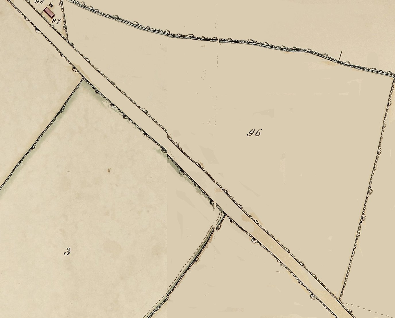
1787:
1853: called Holin Way or Hay and set to arable. Possessed by the Marshalls.
1838: a field bordering the Evesham/Alcester Road and the parish boundary ditch.
1886: there is no indication on the map but this is believed to be where the brickyard is situated, the name given to this hamlet, was situated.
2025: part of this field now a reservoir and agricultural yard.
|
|
| TM 1838 Tithe Map: 097: |
OS 1886/1927: 49 |
Name where known: Ivy Cottage |
Location 097: |
|

1787:
1853 Cottage and garden possessed by the Marshalls at Harvington Lodge.
1838: an old timber-framed Cottage on a patch bordering the Evesham/Alcester Road and the parish boundary ditch.
1886:
2025: the original cottage was demolished some years ago and a modern building erected called Boundary House.
|
|
| TM 1838 Tithe Map: 098: |
OS 1886/1927: 49 |
Name where known: Ivy Cottage |
Location 098: |
|
1787: part of a large open field containing 'Long Dean', 'Twentylands Furlong', 'Dinscroft Furlong' on Schooling map. In 1838 it covered 93, 95, 98, 100, 101. Owned by the Rector.
1853: Cottage and Garden possessed by the Marshalls at Harvington Lodge.
1838: a small triangular close in a corner between the parish boundary ditch and the Evesham/Alcester Road and the parish boundary ditch.
1886: amalgamated with number 097.
2025: the original cottage was demolished some years ago and a modern building was erected called Boundary House.
|
|
| TM 1838 Tithe Map: 099: |
OS 1886/1927: 49 |
Name where known: Green Street Farm |
Location 099: |
|

1838: Green Street Farm.
1886:
2025: Still an active farm.
|
|
| TM 1838 Tithe Map: 100: |
OS 1886/1927: 53 |
Name where known: |
Location 100: |
|

1787: part of a large open field containing 'Long Dean', 'Twentylands Furlong', 'Dinscroft Furlong' on Schooling map. In 1838 it covered 93, 95, 98, 100, 101. Owned by the Rector.
1838: a field bordering the parish boundary ditch and Green Street. There is a pool adjoining the ditch at the eastern end.
1886: merged with field 101.
2025:
|
|
| TM 1838 Tithe Map: 101: |
OS 1886/1927: 53 |
Name where known: |
Location 101: |
|

1787: part of a large open field containing 'Long Dean', 'Twentylands Furlong', 'Dinscroft Furlong' on Schooling map. In 1838 it covered 93, 95, 98, 100, 101. Owned by the Rector.
1838: a field bordering the parish boundary ditch.
1886: merged with field 100.
2025:
|
|
| TM 1838 Tithe Map: 102: |
OS 1886/1927: 90 |
Name where known: Elder Streb/Stubbs/Stump |
Location 102: |
|

1787: part of a large open field containing 'Long Dean', 'Horse Moor Furlong', 'Orchard Town Furlong', 'Middle Furlong', 'Elders Stump Furlong' on Schooling map. In 1838 it covered 102, 103, 104, 105, 106, 107. Owned by Godfrey. Horse Moor Furlong is thought to have covered fields 104 & 105.
1838: a field bordering the parish boundary ditch.
1886: merged with field 103.
1887: estate plan for Langton House records this field as 'Elder Strebb'. [This is a miss translation of 'Stub' see Bailey].
1919: 11-acre field (merged with 103) called The Elder Stubbs (Lot 15), owned by the Penney family and let to Mr Horace White.
1920 Believed to be purchased by Mr Harrison, see Langton deeds.
2025:
|
|
| TM 1838 Tithe Map: 103: |
OS 1886/1927: 90 |
Name where known: Elder Streb/Stubbs/Stump |
Location 103: |
|

1787: part of a large open field containing 'Long Dean', 'Horse Moor Furlong', 'Orchard Town Furlong', 'Middle Furlong', 'Elder Stump Furlong' on Schooling map. In 1838 it covered 102, 103, 104, 105, 106, 107. Owned by Godfrey. Note the name Elder Stump Furlong.
1838: a field. There is a pool in the south-west corner shared with fields 104, 105, 106.
1886: merged with field 102. Pool still insitu.
1919: 11-acre field (merged with 102) called The Elder Stubbs (Lot 15), owned by the Penney family and let to Mr Horace White.
1920 Believed to be purchased by Mr Harrison, see Langton deeds.
2025:
|
|
| TM 1838 Tithe Map: 104: |
OS 1886/1927: 91 |
Name where known: The Hills |
Location 104: |
|

1787: part of a large open field containing 'Long Dean', 'Horse Moor Furlong', 'Orchard Town Furlong', 'Middle Furlong', 'Elders Stump Furlong' on Schooling map. In 1838 it covered 102, 103, 104, 105, 106, 107. Owned by Godfrey. Horse Moor Furlong is thought to cover fields 104 & 105.
1838: a field bordering the parish boundary ditch and the Salford Road. There is a pool in the south-west corner shared with fields 104, 105, 106, part of 108 & 110.
1886: merged with field 105. Pool still insitu.
1887: estate plan for Langton House records this field as 'The Hills'.
1919: 11-acre field known as The Hills (Lot 14) and owned by the Penney family and laid down as market garden.
2025:
|
|
| TM 1838 Tithe Map: 105: |
OS 1886/1927: 91 |
Name where known: The Hills |
Location 105: |
|

1787: part of a large open field containing 'Long Dean', 'Horse Moor Furlong', 'Orchard Town Furlong', 'Middle Furlong', 'Elders Stump Furlong' on Schooling map. In 1838 it covered 102, 103, 104, 105, 106, 107. Owned by Godfrey. Horse Moor Furlong is thought to cover fields 104 & 105.
1838: a field bordering the parish boundary ditch and the Salford Road. There is a pool in the south-west corner shared with fields 104, 105, 106.
1886: merged with field 104. Pool still insitu.
1887: estate plan for Langton House records this field as 'The Hills' and owned by Langton House.
1919: 6-acre field known as The Hills (Lot 13) and owned by the Penney family and laid down as market garden.
2025: In the 1970s this field was owned by Mr Ralph Brazier. It is now partially built upon by a modern house called Oak Tree Farm.
|
|
| TM 1838 Tithe Map: 106: |
OS 1886/1927: 89 |
Name where known: Corner Ground |
Location 106: |
|

1838: a field. There is a pool in the south-west corner shared with fields 104, 105, 106.
1886: merged with field 107. Pool still insitu.
1887: estate plan for Langton House records this field as 'Corner Ground'.
1919: Combined with 107 and split into lots 10, 11, 12 amounting to 17 acres. Field known as Corner Ground, owned by the Penney family and let to Mr C C Moberly. Laid down as market garden.
1920 Possibly purchased by Mr Brazier, see Langton deeds.
2025: partially built upon.
|
|
| TM 1838 Tithe Map: 107: |
OS 1886/1927: 89 |
Name where known: Corner Ground |
Location 107: |
|

1838: a field.
1886: merged with field 106.
1887: estate plan for Langton House records this field as 'Corner Ground'.
1919: Combined with 106 and split into lots 10, 11, 12 amounting to 17 acres. Field known as Corner Ground, Owned by the Penney family and let to Mr C C Moberly. Laid down as market garden.
2025: still used for agriculture.
|
|
| TM 1838 Tithe Map: 108: |
OS 1886/1927: 109 |
Name where known: Gravel Pit Ground |
Location 108: |
|

1787: part of a large open field containing 'Long Dean', 'Horse Moor Furlong', 'Orchard Town Furlong', 'Middle Furlong', 'Elders Stump Furlong' on Schooling map. In 1838 it covered 102, 103, 104, 105, 106, 107. Owned by John Godfrey. Old name may have been 'Behind Town Furlong'.
1838: a large and long field bordering Village Street at the one end and the Salford Road at the other.
1886: merged with field 110.
1887: estate plan for Langton House records this field as 'Gravel Pit Ground'.
1919: see the Southwold deed: by this time this large field had been combined with field 110, amounted to over 18 acres and divided into lots 5, 6, 7, 8, 9. Owned by the Penney family and let to Mr C C Moberly. Laid down to orchard and market garden. In 1920 Alfred Robbins purchased lots 7, 8 & 9. Part of this field was developed in 1965-67 and later. The remaining section is (2025) likely to be laid down to housing.
1997: owned by the Robbins family, see.
Part of the field in 1997; from the deeds of Southwold.
2025: partly still a field, partly the Village playing field, partly housing.
|
|
| TM 1838 Tithe Map: 109: |
OS 1886/1927: 93/font> |
Name where known: Old Gravel Pits/Marl-ol |
Location 109: |
|

1838: a collection of small numbered plots: 9a, 9b, 9c, 9d, 9e, 9f, 9g.
1886: by 1886 the plots have been merged into one plot (93) and collectively called 'The Old Gravel Pits'.
1887: then called 'Old Gravel Pits'.
2025: the hollowed-out area is now known as 'The Marl-ol', part of which may have used for the building of Valley View Cottages.
|
|
| TM 1838 Tithe Map: 110: |
OS 1886/1927: 105 |
Name where known: Gravel Pit Ground |
Location 110: |
|

1787: part of a large open field containing 'Long Dean', 'Horse Moor Furlong', 'Orchard Town Furlong', 'Middle Furlong', 'Elders Stump Furlong' on Schooling map. In 1838 it covered 102, 103, 104, 105, 106, 107. Owned by John Godfrey. Old name may have been 'Behind Town Furlong'.
1838: a field bordering Station Road and Cress Hill.
1886: merged with field 108.
1887: estate plan for Langton House records this field as 'Gravel Pit Ground'.
1919: See the Southwold deed: by this time this large field had been combined with field 108, amounted to over 18 acres and divided into lots 5, 6, 7, 8, 9. Owned by the Penney family and let to Mr C C Moberly. Laid down to orchard and market garden. In 1920 Alfred Robbins purchased lots 7, 8 & 9. Part of this field was developed in 1965-67 and later. The remaining section is (2025) likely to be laid down to housing.
Plots sold in 1965; holding owned by the Robbins family, see Southwold deeds.
2025: lost to housing.
|
|
| TM 1838 Tithe Map: 111: |
OS 1886/1927: 112 |
Name where known: |
Location 111: |
|

1838: a field on Cress Hill and Station Bank down to what was to be Harvington Station. Sloping steeply to the south.
1886: merged with field 111a with the western portion lost the widening of Station Bank and erection of houses leading to the Station.
2025: the southern part of this field was used for the building of Harvington Railway Station. The remainder mostly lost to housing in recent years.
|
|
| TM 1838 Tithe Map: 111a: |
OS 1886/1927: 112 |
Name where known: |
Location 111a: |
|

1838: a field on Cress Hill and sloping steeply to the south.
1853: leased by Mr George Perks sometime prior to this date.
1886: merged with field 111.
2025: now a derelict field.
|
|
| TM 1838 Tithe Map: 112: |
OS 1886/1927: 116 |
Name where known: |
Location 112: |
|

1838: a field approached from Anchor Lane.
1853: leased by Mrs Anne Barker sometime prior to this date.
1886: the northern boundary of this field was lost to the Midland Railway line.
2025: lost to bypasses etc.
|
|
| TM 1838 Tithe Map: 113: |
OS 1886/1927: 116 |
Name wknown: The Moors |
Location 113: |
|

1799: freehold land purchased by Wilson Marshall.
1838: a field.
1853: a freehold field called The Moors, set to Pasture. Leased by Benjamin Bomford as part of the Harvington Lodge Estate but, along with 114 & 122 detached from the main estate - all part of The Moors.
1886: merged with field 114 following the railway.
2025: lost to A46 bypass.
|
|
| TM 1838 Tithe Map: 114: |
OS 1886/1927: 116 |
Name where known: The Moors |
Location 114: |
|

1799: freehold land purchased by Wilson Marshall.
1838: a field bordering Cress Hill. An old footpath ran from Cress Hill south to Anchor Lane.
1853: a freehold field called The Moors, set to Pasture. Leased by Benjamin Bomford as part of the Harvington Lodge Estate but, along with 113 & 122 detached from the main estate - all part of The Moors.
1886: merged with 113 following the building of the railway.
2025: mostly lost to A46 bypass.
|
|
| TM 1838 Tithe Map: 115: |
OS 1886/1927: 157 |
Name where known: The Downs in 1919. |
Location 115: |
|

1838: a field bordering Cress Hill and the short lane.
1853: leased by W H Marshall sometime prior to this date.
!886: merged with 114. It southern boundary was altered due to the construction of the railway.
1919: a 2-acre field called The Downs bordered by the Salford Road, the railway line and the short field lane. Owned by the Penney family and let to Mr A Ludlow, described as old Turf ground.
1920 Believed to be purchased by Mr Ludlow, see Langton deeds.
2025: By this time the inner bypass/Salford Road was greatly altered this area which has virtually obliterated this field.
|
|
| TM 1838 Tithe Map: 116: |
OS 1886/1927: 97,98,99 |
Name where known: Far Moors |
Location 116: |
|

1787: part of a large open field containing 'The Moors' and Nordern'on Schooling map. In 1838 it covered 116, 117, 118, 119, 120, 121. Owned by John Godfrey. Note the name coming through and Nordern and Nurders.
1838: a field bordering the Salford Road and a short lane connecting to field 119.
1886: the Midland Railway line altered fields 116, 117, 118, 119.
1887: estate plan for Langton House records this field as 'Far Moors'. The boundaries changed owing to the railway.
1919: Field of 8 acres called Far Moors (Lot 17). Owned by the Penny family and let to Mr Horace White.
1920 Believed to be purchased by Mr Harrison, see Langton deeds.
2025: lost to fishing ponds.
|
|
| TM 1838 Tithe Map: 117: |
OS 1886/1927: 97,98,99 |
Name where known: First Moors |
Location 117: |
|

1787: part of a large open field containing 'The Moors' and Nordern'on Schooling map. In 1838 it covered 116, 117, 118, 119, 120, 121. Owned by John Godfrey. Note the name coming through and Nordern and Nurders.
1838: a field bordering the Salford Road and the parish boundary ditch.
1886: the Midland Railway line construction altered southern boundary of fields 116, 117, 118, 119.
1887: estate plan for Langton House records this field as 'First Moors'. Southern Boundary changed owing to railway line.
1919: Field of 7 acres called First Moors (Lot 18). Owned by the Penny family and let to Mr Horace White.
1920 Believed to be purchased by Mr Harrison, see Langton deeds.
2025: lost in the creation of the fishing ponds.
|
|
| TM 1838 Tithe Map: 118: |
OS 1886/1927: 97,98,99 |
Name where known: The Park/Little Nurders |
Location 118: |
|

1777: possibly to be identified with the 'The Park' - see Thomas Ramell.
1787: part of a large open field containing 'The Moors' and Nordern'on Schooling map. In 1838 it covered 116, 117, 118, 119, 120, 121. Owned by John Godfrey. Note the name coming through and Nordern and Nurders.
1838: a small field bordering the parish boundary ditch.
1886: the Midland Railway line construction altered southern boundary of fields 116, 117, 118, 119.
1887: estate plan for Langton House records this field as 'Little Nurders'. Bounderies changed owing to railway line.
1919:
2025: lost to fishing ponds. There is an ancient willow close the ditch.
|
|
| TM 1838 Tithe Map: 119: |
OS 1886/1927: 97,98,99 |
Name where known: The Moors/Little Nurders |
Location 119: |
|

1777: possibly to be identified with 'The Moors'.
1787: part of a large open field containing 'The Moors' and Nordern'on Schooling map. In 1838 it covered 116, 117, 118, 119, 120, 121. Owned by John Godfrey. Note the name coming through and Nordern and Nurders.
1838: a field accessed by a short field lane from the Salford Road.
1886: the Midland Railway line altered fields 116, 117, 118, 119.
1887: estate plan for Langton House records this field as 'Little Nurders'. Boundaries changed owing to the construction of the railway.
1919: field of 7 acres known as Little Nurders. Owned by the Penney family and let to Mr Horace White.
2025: lost to construction of the fishing ponds.
|
|
| TM 1838 Tithe Map: 120: |
OS 1886/1927: 104 & 10 |
Name where known: |
Location 120: |
|

1787: part of a large open field containing 'The Moors' and Nordern'on Schooling map. In 1838 it covered 116, 117, 118, 119, 120, 121. Owned by John Godfrey. Note the name coming through and Nordern and Nurders.
1838: an irregular-shaped field partially bordering the parish boundary ditch.
1853: leased by W H Marshall sometime prior to this date.
1886: divided into two the south-eastern part being laid down to wood.
2025: lost to fishing ponds and A46 bypass.
|
|
| TM 1838 Tithe Map: 121: |
OS 1886/1927: 9 |
Name where known: |
Location 121: |
|

1787: part of a large open field containing 'The Moors' and Nordern'on Schooling map. In 1838 it covered 116, 117, 118, 119, 120, 121. Owned by John Godfrey. Note the name coming through and Nordern and Nurders.
1838: a field bordering the parish boundary ditch.
1886:
2025:
|
|
| TM 1838 Tithe Map: 122: |
OS 1886/1927: 114 |
Name where known: The Moors |
Location 122: |
|

1799: freehold land purchased by Wilson Marshall.
1838: a small square field.
1853: a freehold field called The Moors, set to arable. Leased by Benjamin Bomford as part of the Harvington Lodge Estate but, along with 113 & 114 detached from the main estate - all part of The Moors.
1886: unaltered.
2025:
|
|
| TM 1838 Tithe Map: 123: |
OS 1886/1927: 115 |
Name where known: The Moors |
Location 123: |
|

1777: a field identified on the Ramell plan as above Longlands.
1838: a field.
1886: the barn (123a) is in its south-eastern corner.
2025: now open fields.
|
|
| TM 1838 Tithe Map: 123a: |
OS 1886/1927: 115 |
Name where known: |
Location 123a: |
|

1787:
1838: an L-shaped barn.
1886: a rectangular barn in the south-east corner of field 123.
2025: there is now little sign of this structure apart from some Blue Lias stone two old trees and ditches with surrounding open fields and a tract heading towards Longlands. The sarn was in existence sixty years ago. This building probably doubled up as a hovel. See under 'Notes & Queries' for more detail.
|
|
| TM 1838 Tithe Map: 124: |
OS 1886/1927: 9 |
Name where known: Great Nestor |
Location 124: |
|

1777: identified on the Ramell plan as Great Nestor (15).
1787: part of a large open field called the 'The Nestor' on Schooling map. In 1838 was divided into 124, 126, 127. Owned by Elizabeth Marshall.
1838: an irregular-shaped field bordering the parish boundary ditch.
1886: unaltered.
2025:
|
|
| TM 1838 Tithe Map: 125: |
OS 1886/1927: 7 & 8 |
Name where known: |
Location 125: |
|

1787: part narrow belt of trees owned by Elizabeth & Thomas Walford Marshall.
1838: a long-narrow belt of trees adjacent to the parish boundary ditch.
1886:
2025:
|
|
| TM 1838 Tithe Map: 126: |
OS 1886/1927: 12 |
Name where known: Little Nestor |
Location 126: |
|

1777: identified on the Ramell plan as Little Nestor (14).
1787: part of a large open field called the 'The Nestor' on Schooling's map. In 1838 was divided into 124, 126, 127. Owned by Elizabeth Marshall.
1838: a field with a short footpath at its western end.
1886:
2025: merged with field 127.
|
|
| TM 1838 Tithe Map: 127: |
OS 1886/1927: 12 |
Name where known:The Narles |
Location 127: |
|

1787: Called 'The Narles' on Schooling map. Owned by Thomas Ramell.
1838: a field bordering by the river. a short footpath extends along its western hedge line.
1886: its southern boundary is altered and bordered by trees. It has been merged with field 126.
2025: now open fields.
|
|
| TM 1838 Tithe Map: 128: |
OS 1886/1927: 163 |
Name where known: Longlands |
Location 128: |
|

1777: identified on the Ramell plan as Longlands (12).
1838: a field.
1886: unaltered.
2025: now part of open field. Its southern hedge line is still intact.
|
|
| TM 1838 Tithe Map: 129: |
OS 1886/1927: 162 |
Name where known: Longlands |
Location 129: |
|

1777: identified on the Ramell plan as Longlands (11).
1838: a field.
1886: unaltered.
2025: now part of open field. Its southern hedge line is still intact with a track on the inside.
|
|
| TM 1838 Tithe Map: 130: |
OS 1886/1927: 161 |
Name where known: Longlands |
Location 130: |
|

1777: identified on the Ramell plan as Longlands (10).
1838: a field with Longlands and a barn & house in its southern corners.
1886: laid down to orchard.
2025: now with an extended Longlands.
|
|
| TM 1838 Tithe Map: 131: |
OS 1886/1927: 160 |
Name where known: |
Location 131: |
|

1787:
1838: a field.
1886: unaltered.
2025:
|
|
| TM 1838 Tithe Map: 132: |
OS 1886/1927: 158 |
Name where known: |
Location 132: |
|

1787:
1838: a field bordering Anchor Lane and Mill Lane.
1886: its northern tip has been slightly affected by the nearby railway line.
2025: the northern tip has been obliterated by the A46 bypass. Half the remainder is now the cricket pitch and the other half still a field.
|
|
| TM 1838 Tithe Map: 133: |
OS 1886/1927: 167 |
Name where known: |
Location 133: |
|
1787: Apparently divided into Holloway Close, Orchard Close and other pieces of land. Apparently owned by Elizabeth & Thomas Walford Marshall.
1838: a large and long field bordering Anchor Lane and Mill Lane. There is a short footpath between Anchor and Mill lanes.
1886:
2025: still used for agriculture.
|
|
| TM 1838 Tithe Map: 134: |
OS 1886/1927: 166 |
Name where known: Lower Field |
Location 134: |
|

1787: a Called 'Lower Field' and owned by Elizabeth & Thomas Walford Marshall.
1838: a large field bordering the river with Mill Lane running through it.
1886: merged with field 135.
2025: still used for agriculture.
|
|
| TM 1838 Tithe Map: 135: |
OS 1886/1927: 166 |
Name where known: |
Location 135: |
|

There is a assumed prehistoric crop circle and marks in this area.
1787:
1838: a field bordering the river with Mill Lane running through it.
1886: merged with field 134.
2025: still used for agriculture.
|
|
| TM 1838 Tithe Map: 136: |
OS 1886/1927: 172 |
Name where known: Town Rushings |
Location 136: |
|

1787: Called Town Rushings and owned by Evans or Ewans.
1838: a field bordering Mill Lane. There is a small hut on its north-eastern side.
1886: depicts trees in parts of field.
2025: within the last fifty years a new road/driveway to Mill House was cut through this field.
|
|
| TM 1838 Tithe Map: 137: |
OS 1886/1927: 173 |
Name where known: Mill Close |
Location 137: |
|

Suggest this Mill Close.
1787:
1838: a field bordering Mill Lane.
1886:
2025: within the last fifty years a new road/driveway to Mill House was cut through this field.
|
|
| TM 1838 Tithe Map: 138: |
OS 1886/1927: 175 |
Name where known: The Mill |
Location 138: |
|

1787: Numbers 138, 139, 142, 143, 144, 145, 146 owned by Chamberlain at the mill.
1838: a close bordering the river and Mill Lane.
1886:
2025: within the last fifty years houses have been built upon this patch.
|
|
| TM 1838 Tithe Map: 139: |
OS 1886/1927: 174 |
Name where known: The Mill |
Location 139: |
|
1787: Numbers 138, 139, 142, 143, 144, 145, 146 owned by Chamberlain at the mill.
1838: a close bordering the river and Mill Lane.
1886:
2025: within the last forty years houses have been built upon this patch.
|
|
| TM 1838 Tithe Map: 140: |
OS 1886/1927: 174 |
Name where known: Mill House |
Location 138: |
|
1787: Numbers 138, 139, 142, 143, 144, 145, 146 owned by Chamberlain at the mill.
1838: Mill House bordering the river.
1886:
2025: within the last forty the house has been enlarged.
|
|
| TM 1838 Tithe Map: 141: |
OS 1886/1927: 165 |
Name where known: Mill Cottage etc. |
Location 141: |
|
1787: Numbers 138, 139, 142, 143, 144, 145, 146 owned by Chamberlain at the mill.
1838: Mill Cottage etc. bordering the river.
1886:
2025: within the last fifty years the cottage has been virtually rebuilt and outbuildings renovated.
|
|
| TM 1838 Tithe Map: 142: |
OS 1886/1927: 173 |
Name where known: The Mill |
Location 142: |
|

1787: Numbers 138, 139, 142, 143, 144, 145, 146 owned by Chamberlain at the mill.
1838: a close bordering the river with Mill Lane passing through it.
1886:
2025: within the last fifty years the throughway of Mill Lane to the Mill has been blocked.
|
|
| TM 1838 Tithe Map: 143: |
OS 1886/1927: 13 |
Name where known: The Mill |
Location 143: |
|

Before 1800 a mill house called the forge is believed to have stood upon the island.
1787: an ait in the river. Numbers 138, 139, 142, 143, 144, 145, 146 owned by Chamberlain at the mill.
: an ait in the river with weir and lock.
1886: more detail with orchard and a pool.
2025: now tree covered.
|
|
| TM 1838 Tithe Map: 144: |
OS 1886/1927: 13 |
Name where known: The Mill |
Location 144: |
|
1787: An ait in the river. Numbers 138, 139, 142, 143, 144, 145, 146 owned by Chamberlain at the mill.
1838: an ait in the river with lock, mill, and a track leading to a ford.
1886: more and changed detail plus a pool.
2025: mill still standing but derelict.
|
|
| TM 1838 Tithe Map: 145: |
OS 1886/1927: 13 |
Name where known: The Mill |
Location 145: |
|
1787: An ait in the river. Numbers 138, 139, 142, 143, 144, 145, 146 owned by Chamberlain at the mill.
1838: two small patches in the river.
1886: more detail with trees.
2025: cleared to make way for modern lock.
|
|
| TM 1838 Tithe Map: 146: |
OS 1886/1927: 13 |
Name where known: The Mill |
Location 146: |
|
1787: An ait in the river. Numbers 138, 139, 142, 143, 144, 145, 146 owned by Chamberlain at the mill.
1838: an ait in the river.
1886: more detail with trees.
2025:
|
|
| TM 1838 Tithe Map: 147: |
OS 1886/1927: 179 |
Name where known: The Lots |
Location 147: |
|

1787:
1838: a field bordering Anchor Lane and the mill. A footpath runs across this field from the mill to Anchor Lane.
1886: footpath not shewing.
2025:
|
|
| TM 1838 Tithe Map: 148: |
OS 1886/1927: 179 |
Name where known: New Meadow |
Location 148: |
|

1787: Called New Meadow along with 149 and owned by Chamberlain.
1838: a field bordering Anchor Lane and the river. A footpath runs across this field from the mill to Anchor Lane.
1886: footpath not shewing.
2025: now field and golf course.
2026: the golf course was sold to the Heart of England Forest, based at Dorsington.
|
|
| TM 1838 Tithe Map: 149: |
OS 1886/1927: 180 |
Name where known: New Meadow |
Location 149: |
|

1787: Called New Meadow along with 148 and owned by Elizabeth & Thomas Walford Marshall.
1838: a field bordering Anchor Lane and the river. A footpath runs across this field from the mill to Anchor Lane.
1886: footpath not shewing.
2025: now field and golf course.
2026: the golf course was sold to the Heart of England Forest, based at Dorsington.
|
|
| TM 1838 Tithe Map: 150: |
OS 1886/1927: 189 |
Name where known: Anchor Meadow |
Location 150: |
|

1787: Called Great & Little Herbert along with 151 and owned by John Godfrey.
1838: a field bordering Anchor Lane and the river. A footpath runs across this field from the mill to Anchor Lane.
1886: footpath not shewing.
1919: With field 151 known as Anchor Meadow of 14 acres. See Southwold deed.
2025: now field.
|
|
| TM 1838 Tithe Map: 151: |
OS 1886/1927: 189 |
Name where known: Anchor Meadow |
Location 151: |
|

1787: Called Great & Little Herbert along with 150 and owned by John Godfrey.
1838: Anchor Lane widens at this point before it ends at the ford. A footpath continues across Anchor Lane and onwards.
1886: field now merged with 152. Footpath not shewing.
1919: With field 150 known as Anchor Meadow of 14 acres. Owned by the Penney's of Cedar Lodge and rented by Mr A Ludlow. See Southwold deed.
2025: now an open area.
|
|
| TM 1838 Tithe Map: 152: |
OS 1886/1927: 189 |
Name where known: |
Location 152: |
|

1787: Numbers 152, 153, 157, 158 possibly called Berry Lynch. Owned by the Rector.
1838: Bordering the river. Anchor Lane widens at this point before it ends at the ford. A footpath continues across Anchor Lane and onwards.
1886: now merged with 151. Footpath not shewing.
2025: now an open area except for a raised static home.
|
|
| TM 1838 Tithe Map: 153: |
OS 1886/1927: 188 & 191 |
Name where known: |
Location 153: |
|

1787: Numbers 152, 153, 157, 158 possibly called Berry Lynch. Owned by the Rector.
1838: a field bordering the river. A footpath continues across Anchor Lane and onwards.
1886: a patch adjacent to the river has been designated a number - 191. Footpath not shewing.
2025:
|
|
| TM 1838 Tithe Map: 154: |
OS 1886/1927: 187 |
Name where known: Hynham Meadow |
Location 154: |
|

1787: part of Big River Meadow.
1838: a field bordering the river and the parish boundary/Harvington Brook. A footpath continues but at this point it runs sharp right to the east towards field 156.
1886: footpath not shewing.
2025: now an open area.
2026: the golf course was sold to the Heart of England Forest, based at Dorsington.
|
|
| TM 1838 Tithe Map: 155: |
OS 1886/1927: 185 |
Name where known: |
Location 155: |
|

1787:
1838: a field bordering the parish boundary/Harvington Brook.
1886: merged with field 155.
In the 1970s an adjacent field but across the parish boundary into the Norton parish was owned or rented by the Brazier family which they utilised for growing crops. The tractor drivers were John Simmons and Barry Ludlow (information from David Byrd).
2025: now part of a golf course.
2026: the golf course was sold to the Heart of England Forest, based at Dorsington.
|
|
| TM 1838 Tithe Map: 156: |
OS 1886/1927: 185 |
Name where known: Round Hill |
Location 156: |
|

Field 156 & Joy on site in November 2025.
The 'Round Hill' refers to a large interesting feature in this field. There is a distinctive roughly-circular raised area in an otherwise flat terrain which is subject to flooding. The land around was agricultural with evidence of nearby ridge and furrow. The Byrd family purchased Manor Farm and converted this part of the farm into a golf course and a certain amount of small-scale landscaping took place. They called the feature 'The Bank' and in their time it had been utilised for allotments. There was access to a nearby spring. There is a high probability that the feature was utilized in some way by folk in the past - were there ever a settlement upon it?
1787: Called Round Hill and owned by Thomas Ramell.
1838: a field with a footpath running down the side.
1886: merged with field 155.
2025: now part of a golf course.
2026: the golf course was sold to the Heart of England Forest, based at Dorsington.
|
|
| TM 1838 Tithe Map: 157: |
OS 1886/1927: 181 |
Name where known: |
Location 157: |
|

1787: Numbers 152, 153, 157, 158 possibly called Berry Lynch. Owned by the Rector.
1838: a field with small hut.
1886: merged with 158.
2025: now part of a golf course.
2026: the golf course was sold to the Heart of England Forest, based at Dorsington.
|
|
| TM 1838 Tithe Map: 158: |
OS 1886/1927: 181 |
Name where known: |
Location 158: |
|

this field has existed for a long time, as within its boundaries is ridge and furrow and headlands defining it to its present hedgeline, see under Histories/Rawes part 2.
1787: Numbers 152, 153, 157, 158 possibly called Berry Lynch. Owned by the Rector.
1838: a field bordering Anchor Lane.
1886: merged with 157.
2025: now part of a golf course.
2026: the golf course was sold to the Heart of England Forest, based at Dorsington.
|
|
| TM 1838 Tithe Map: 159: |
OS 1886/1927: 182 |
Name where known: |
Location 159: |
|

1787:
1838: a small field bordering Anchor Lane. A footpath runs along its southern boundary before exiting in Anchor Lane. This footpath is still in existence and starts at the Church.
1886:
2025: now part of a golf course.
2026: the golf course was sold to the Heart of England Forest, based at Dorsington.
|
|
| TM 1838 Tithe Map: 160: |
OS 1886/1927: 183 |
Name where known: |
Location 160: |
|

1787: Owned b Rector.
1838: a field bordering Anchor Lane. A footpath crosses the field. The northern boundary is still in existence.
1886:
2025: now part of a golf course.
2026: the golf course was sold to the Heart of England Forest, based at Dorsington.
|
|
| TM 1838 Tithe Map: 161: |
OS 1886/1927: 184 |
Name where known: |
Location 161: |
|

1787:
1838: a field bordering the parish boundary/Harvington Brook. A footpath crosses the field being joined from one to the south.
1886: merged with field 162.
2025: now part of a golf course.
2026: the golf course was sold to the Heart of England Forest, based at Dorsington.
|
|
| TM 1838 Tithe Map: 162: |
OS 1886/1927: 181 |
Name where known: The Small Moor |
Location 162: |
|

1787: Fields 162, 163, 164, 165 called the Small Moor. Owned by Williams.
1838: a small field bordering Anchor Lane. A footpath runs along its eastern hedge line.
1886: merged with 161.
2025: now a pool and wood.
|
|
| TM 1838 Tithe Map: 163: |
OS 1886/1927: 171 |
Name where known: Small Moor |
Location 163: |
|

1787: Fields 162, 163, 164, 165 called the Small Moor. Owned by Williams.
1838: a field bordering Anchor Lane.
1886: merged with 161.
2025: now a pool and wood.
|
|
| TM 1838 Tithe Map: 164: |
OS 1886/1927: 170 |
Name where known: Small Moor |
Location 164: |
|

1787: Fields 162, 163, 164, 165 called the Small Moor. Owned by Williams.
1838: a field bordering both Anchor Lane and the parish boundary/Harvington Brook. A footpath runs through this field.
1886:
2025: now a caravan park.
|
|
| TM 1838 Tithe Map: 165: |
OS 1886/1927: 110 |
Name where known: Small Moor |
Location 165: |
|

1787: Fields 162, 163, 164, 165 called the Small Moor. Owned by Williams.
1838: a field bordering both Anchor Lane and the parish boundary/Harvington Brook. A footpath runs through this field.
1886:
2025: now a caravan park
|
|
| TM 1838 Tithe Map: 166: |
OS 1886/1927: 157 |
Name where known: |
Location 166: |
|

There were watercress fields somewhere on the lower reaches of this field.
1777: the Ramell Terrier suggests that this field may have been rented or owned by the Revd M Williams.
1838: a field bordering both Anchor Lane and the parish boundary/Harvington Brook. A footpath runs through this field.
1886: by this time the railway line had been built which cut the field in half. Otherwise depicted as orchard.
2025: The northern and sloping half is still intact and owned by Max Byrd. It is now laid down to grass but was in past times a cherryrd. The southern half has been greatly reduced by the bypasses leaving only a small area of grassland. In the 1960/70s Mr Moss of 'Moss' shop' used to keep his dairy cows on this field.
|
|
| TM 1838 Tithe Map: 167: |
OS 1886/1927: 117 |
Name where known: |
Location 167: |
|

1787:
1838: a small patch of scrub land on the western side of Station Bank/Anchor Lane.
1886: merged with 168.
2025: still there.
|
|
| TM 1838 Tithe Map: 168: |
OS 1886/1927: 117 |
Name where known: |
Location 168: |
|
1787:
1838: a small patch of scrub land on the western side of Station Bank/Anchor Lane.
1886: merged with 167.
2025: still there.
|
|
| TM 1838 Tithe Map: 169: |
OS 1886/1927: 118 |
Name where known: Grove Lodge etc. |
Location 169: |
|
1787:
1838: a patch of scrub land on the eastern side of Station Bank/Anchor Lane.
1886: by 1886 the railway was in operation and this land widened and used for housing, Grove Lodge for instance.
2025:
|
|
| TM 1838 Tithe Map: 170: |
OS 1886/1927: 117 |
Name where known: |
Location 170: |
|

1787:
1838: a patch of steeply sloping scrub land on the western side of Station Bank. Station Bank/Anchor Lane is deeply sunken lane at this point.
1886: by 1886 the railway was in operation by this time and this area may have been widened.
2025:
|
|
| TM 1838 Tithe Map: 171: |
OS 1886/1927: 121 |
Name where known: Manor Farm |
Location 171: |
|

1787:
1838: Manor Farm, its farm buildings, garden, pool and dovecote etc., approached from the top of Station Bank/Anchor Lane.
1886: shewn in fine detail.
2025: Farm buildings were demolished and modern houses erected.
|
|
| TM 1838 Tithe Map: 172: |
OS 1886/1927: 122/123 |
Name where known: Grove Lodge etc. |
Location 172: |
|
1787:
1838: a field south of Manor Farm.
1886: laid down as orchard.
2025: remains much the same.
|
|
| TM 1838 Tithe Map: 173: |
OS 1886/1927: 124 |
Name where known: St James the Great |
Location 173: |
|

In previous times the village pound existed in the north-east corner by the dovecote.
1787:
1838: the Parish Church.
1886:
2025:
|
|
| TM 1838 Tithe Map: 174: |
OS 1886/1927: 124 |
Name where known: Candle Cottage |
Location 174: |
|

1787:
1838: Candle Cottage.
1886:
2025:
|
|
| TM 1838 Tithe Map: 175: |
OS 1886/1927: 124 |
Name where known: Church House/Cottage |
Location 175: |
|
1787:
1838: Church House and Cottage.
1886:
2025:
|
|
| TM 1838 Tithe Map: 176: |
OS 1886/1927: 125 |
Name where known: Apple tree Cottage & James Cottage |
Location 176: |
|
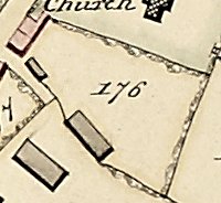
1787:
1838: two timber-framed cottages a small barn and the hop kiln building.
1886: the area around it is laid down as orchard.
2025: the hop kiln is now converted into two houses.
|
|
| TM 1838 Tithe Map: 177: |
OS 1886/1927: 129 |
Name where known: Crooked Walls |
Location 177: |
|

1787:
1838: Crooked Walls .
1886: more details plus toiled blocks.
2025: garden extended in 1930s.
|
|
| TM 1838 Tithe Map: 178: |
OS 1886/1927: 129 |
Name where known: |
Location 178: |
|
1787:
1838: a close to the west of Crooked Walls.
1886:
2025: now part of garden of 1, Hopkiln Cottages.
|
|
| TM 1838 Tithe Map: 179: |
OS 1886/1927: 129 |
Name where known: |
Location 179: |
|
1787:
previously thought to be cherry orchard or hop field.
1838: a close behind Crooked Walls and extending back to Shakespeare Lane. Two timber barns one possibly housing a cider press.
1886: more detail.
2025: lost to houses and yard.
|
|
| TM 1838 Tithe Map: 180: |
OS 1886/1927: 129 |
Name where known: Blacksmiths Cottages |
Location 180: |
|
1787:
1838: Blacksmith's cottages.
1886: more detail.
2025: demolished in 1930s for road widening.
|
|
| TM 1838 Tithe Map: 181: |
OS 1886/1927: 126 |
Name where known: Orchard |
Location 181: |
|

1787:
1838: a close laid down as orchard.
1870 document of possession in the Bank House deeds (originally possessed by the Grange), gives the name for the field as 'Orchard'.
1886:
2025: now the Burial Ground.
|
|
| TM 1838 Tithe Map: 182: |
OS 1886/1927: 127 |
Name where known: the Shakespeare |
Location 182: |
|

1787:
1838: the Shakespeare with its outbuildings.
1886:
2025: a private house since the 1960s.
|
|
| TM 1838 Tithe Map: 183: |
OS 1886/1927: 128 |
Name where known: Home Orchard |
Location 183: |
|
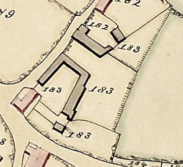
1777: Known as Home Orchard on the Ramell Terrier.
1838: the Limes and farm buildings.
1886: the ownership of a piece of land extending behind The Limes and the Shakespeare.
2025: farm buildings a now a private residence.
|
|
| TM 1838 Tithe Map: 184: |
OS 1886/1927: 152 |
Name where known: Thatchholm |
Location 184: |
|

1787:
1838: numbers 184, 185 & 186 are adjacent to what was the Norton Road but is now called Stratford Road. The property divisions of the properties, as depicted on the 1838 tithe map, are complex and need some explanation. The first timber-framed cottage is Thatchholm but in 1838 it appears to be divided, despite being very small (similar to Candle Cottage). The property division (185) contains part of 184, plus an extra cottage, plus another cottage. The present Thatchways was itself extended but only in the twentieth century. There appears to be two explanations here: 1/ the 1838 map is incorrect; 2/ one of the three habitations was demolished between 1838 and 1884. Judging by the shapes of the buildings on the 1838 map, the most likely explanation is that Number 185 represents Thatchways and Number 186 represents a cottage lost between 1838 and 1886.
1886: similar to the present time.
2025:
|
|
| TM 1838 Tithe Map: 185: |
OS 1886/1927: 152 |
Name where known: Thatchways |
Location 185: |
|
1787:
1838: a small cottage adjacent to Stratford Road.
1886:
2025: see No. 184.
|
|
| TM 1838 Tithe Map: 186: |
OS 1886/1927: 152 |
Name where known: |
Location 186: |
|
1787:
1838: a small cottage adjacent to Stratford Road.
1886:
2025: see No. 184.
|
|
| TM 1838 Tithe Map: 187: |
OS 1886/1927: 152 |
Name where known: Thatchholm |
Location 187: |
|
1787:br>
1838: a small close adjacent to the Stratford Road and the parish boundary/Harvington Brook.
1886: laid down to trees or orchard.
2025: this is now an extended garden to Thatchways. See No. 184.
|
|
| TM 1838 Tithe Map: 188: |
OS 1886/1927: 153 |
Name where known: Home Orchard |
Location 188: |
|

1777: identified on the Ramell plan as Home Orchard (1).
1838: a field extending up from the parish boundary/Harvington Brook.
1886: laid down to orchard.
2025: now scrubland owned by Woodlands Worcestershire Ltd.
|
|
| TM 1838 Tithe Map: 189: |
OS 1886/1927: 151 |
Name where known: Firbank |
Location 189: |
|

1787:
1838: Firbank, its outbuildings.
1886:
2025:
|
|
| TM 1838 Tithe Map: 190: |
OS 1886/1927: 151 |
Name where known: |
Location 190: |
|

In early medieval times the adjacent crossing of the Harvington Brook is believed to have been called 'Carkford'.
1787: along with 191 & 192 owned by Evans or Ewans.
1838: a field bordering Stratford Road and the parish boundary/Harvington Brook.
1886: depicted as an orchard and part of Firbank.
2025: now extends over the parish boundary/Harvington Brook but owned by the owners of 'The Orchard', built on the upper part of the field.
|
|
| TM 1838 Tithe Map: 191: |
OS 1886/1927: 150 |
Name where known: |
Location 191: |
|

1787: along with 190 & 193 owned by Evans or Ewans.
1838: a small field against the parish boundary/Harvington Brook.
1886: depicted as orchard.
2025: now part of the land owned by the owners of 'The Orchard'.
|
|
| TM 1838 Tithe Map: 192: |
OS 1886/1927: 149 |
Name where known: |
Location 192: |
|

1787: along with 190 & 191 owned by Evans or Ewans.
1838: a field bordering the parish boundary/Harvington Brook.
1886: depicted as part orchard.
2025:
|
|
| TM 1838 Tithe Map: 193: |
OS 1886/1927: 147 |
Name where known: |
Location 193: |
|

1787: along with 194 owned by Thomas Ramell.
1838: a long field stretching from the parish boundary/Harvington Brook. a footpath crosses its east end.
1886:
2025: still a field.
|
|
| TM 1838 Tithe Map: 194: |
OS 1886/1927: 148 |
Name where known: |
Location 194: |
|

1787: along with 193 owned by Rawmell.
1838: a small square field.
1886: depicted as orchard.
2025: still a field.
|
|
| TM 1838 Tithe Map: 195: |
OS 1886/1927: 136 |
Name where known: |
Location 195: |
|

1787:
1838: a small field surrounded on three sides by a band of trees with a footpath running through its northern side. The Bank House complex appear to have encroached on its north-eastern corner.
1886: laid down as orchard. It appears to have lost its tree band on its eastern side.
2025: still an orchard purchased by the owners of The Laurels within the last 20 years. This field exhibits a curious feature suggestive of an old fortification, but apart from its shape and its band of trees there is no reason to believe there is more to it, nevertheless an interesting feature on the 1838 & 1884 maps.
|
|
| TM 1838 Tithe Map: 196: |
OS 1886/1927: 135 |
Name where known: The Laurels |
Location 196: |
|

1787:
1838: The Laurels, a large timber-framed and Georgian house.
1886:
2025:
|
|
| TM 1838 Tithe Map: 197: |
OS 1886/1927: 134 |
Name where known: Bank House |
Location 197: |
|

1787:
1838: a timber-framed cottage.
1886: built against and eventually replaced by Bank House.
2025: Now Bank House.
|
|
| TM 1838 Tithe Map: 198: |
OS 1886/1927: 134 |
Name where known: The Bank |
Location 198: |
|
1787:
1838: a timber-framed cottage.
1886: the same cottage but soon to be demolished to make way for gardens.
2025: now two detached houses.
|
|
| TM 1838 Tithe Map: 199: |
OS 1886/1927: 132 |
Name where known: Malt House complex & Bank Cottage |
Location 199: |
|
1787:
1838: a series of stone and timber-framed cottages and land.
1886:
2025: Now various properties.
|
|
| TM 1838 Tithe Map: 200: |
OS 1886/1927: 137 |
Name where known: The Orchard |
Location 200: |
|
1787:
1838: a field.
1870 document of possession in the Bank House deeds (originally possessed by the Grange), gives the name for the field as 'The Orchard'.
1886: laid down to orchard.
2025: lost to housing.
|
|
| TM 1838 Tithe Map: 201: |
OS 1886/1927: 131 |
Name where known: The Steps |
Location 201: |
|
1787:
1838: The Steps
1886:
2025:
|
|
| TM 1838 Tithe Map: 202: |
OS 1886/1927: 131 |
Name where known: The Old Bakery |
Location 202: |
|
1787:
1838: The Old Bakery.
1886:
2025:
|
|
| TM 1838 Tithe Map: 203: |
OS 1886/1927: 139 |
Name where known: The Rectory |
Location 203: |
|

1787:
1838: The Rectory and its gardens.
1886: by this time the house had been greatly extended on western side and includes land 134 and part of 135 on the south and eastern side.
2025: part of the house demolished and the garden greatly reduced by the building of houses in the garden.
|
|
| TM 1838 Tithe Map: 204: |
OS 1886/1927: 141 |
Name where known: |
Location 204: |
|

1787:
1838: a field at the top of Finch Lane with a cottage intruding into it. Crossed by a footpath
1886: laid down to orchard and the cottage (205) gone.
2025: lost to housing.
|
|
| TM 1838 Tithe Map: 205: |
OS 1886/1927: 141 |
Name where known: |
Location 205: |
|
1787:
1838: a cottage.
1886: by this time the cottage had gone and now part of field 204 and orchard.
2025: lost to access road.
|
|
| TM 1838 Tithe Map: 206: |
OS 1886/1927: 141 |
Name where known: Finch Hay |
Location 206: |
|
1787:
1838: Finch Hay.
1886:
2025:
|
|
| TM 1838 Tithe Map: 207: |
OS 1886/1927: 141 |
Name where known: Rose Cottage |
Location 207: |
|
1787:
1838: Rose Cottage.
1886:
2025:
|
|
| TM 1838 Tithe Map: 208: |
OS 1886/1927: 141 |
Name where known: |
Location 208: |
|
1787:
1838: a close set behind Rose Cottage.
1886:
2025: now part of the garden to Rose Cottage.
|
|
| TM 1838 Tithe Map: 209: |
OS 1886/1927: 140 |
Name where known: Rick & Orchard |
Location 209: |
|

1787:
1838: a field adjacent to the farm buildings of the Grange.
1870 document of possession in the Bank House deeds (originally possessed by the Grange), gives the name for the field as 'Rick & Orchard'.
1886: laid down as orchard.
2025: lost to housing.
|
|
| TM 1838 Tithe Map: 210: |
OS 1886/1927: 140 |
Name where known: Farm buildings and yard to the Grange |
Location 210: |
|
1787:
1838: farm buildings and yard to the Grange.
1886:
2025: part new housing, part converted to housing.
|
|
| TM 1838 Tithe Map: 211: |
OS 1886/1927: 140 |
Name where known: Yew tree Cottage |
Location 211: |
|
1787:
1838: Yew Tree Cottage.
1886:
2025:
|
|
| TM 1838 Tithe Map: 212: |
OS 1886/1927: 110 |
Name where known: Grounds to the Grange |
Location 212: |
|
1787:
1838: grounds to the Grange.
1886: a drive approached through pillars to the Grange and its grounds.
2025: partly gardens, partly drive to various properties.
|
|
| TM 1838 Tithe Map: 213: |
OS 1886/1927: 110 |
Name where known: |
Location 213: |
|
1787:
1838: a close adjacent to the farm buildings of the Grange.
1886: laid down as orchard.
2025: lost to housing.
|
|
| TM 1838 Tithe Map: 214: |
OS 1886/1927: 110 |
Name where known: Grange Lane Cottages |
Location 214: |
|
1787:
1838: tied cottages (214,215) belonging to the Grange. set in the rear of these properties are several large barns (214,215,218).
1886: the barns are depicted in more detail.
2025: demolished in the 1940s to make way for housing.
|
|
| TM 1838 Tithe Map: 215: |
OS 1886/1927: 110 |
Name where known: Grange Lane Cottages |
Location 215: |
|
1787:
1838: tied cottages belonging to the Grange.
1886:
2025: demolished in the 1940s to make way for housing.
|
|
| TM 1838 Tithe Map: 216: |
OS 1886/1927: 110 |
Name where known: |
Location 216: |
|
1787:
1838: a field adjacent to the farm buildings of the Grange.
1886: laid down as orchard.
2025: lost to housing.
|
|
| TM 1838 Tithe Map: 217: |
OS 1886/1927: 110 |
Name where known: |
Location 217: |
|
1787:
1838: a field adjacent to the farm buildings of the Grange.
1886: laid down as orchard.
2025: lost to housing.
|
|
| TM 1838 Tithe Map: 218: |
OS 1886/1927: 110 |
Name where known: |
Location 218: |
|
1787:
1838: a field adjacent to the farm buildings of the Grange.
1886: laid down as tree covered.
2025: lost to housing.
|
|
| TM 1838 Tithe Map: 219: |
OS 1886/1927: 110 |
Name where known: |
Location 219: |
|
1787:
1838: a field adjacent to the farm buildings of the Grange.
1886: laid down as tree covered.
2025: lost to housing.
|
|
| TM 1838 Tithe Map: 220: |
OS 1886/1927: 72 |
Name where known: |
Location 220: |
|

1787:
1838: a field running westward from Hughes Lane until ending with two large barns and properties on Grange Lane.
1886: depicts a building in the north-eastern corner with some trees.
1967:
part of this field was known as a plum orchard.
2025: lost to the building of Hughes Close.
|
|
| TM 1838 Tithe Map: 221: |
OS 1886/1927: 84/5 |
Name where known: |
Location 221: |
|
1787:
1838: a field running from Hughes Lane westward behind Glebe Cottages to Grange Lane.
1886:
2025: lost to housing in 1930s.
|
|
| TM 1838 Tithe Map: 222: |
OS 1886/1927: 73 |
Name where known: Mona Cottage & |
Location 222: |
|
1787:
1838: original cottage purchased by the Hughes family.
1886:
2025: Demolished in 1912 and replaced by Mona Cottage and Horse Shoe Cottage.
|
|
| TM 1838 Tithe Map: 223: |
OS 1886/1927: 84/5 |
Name where known: Glebe Cottages |
Location 223: |
|
1787:
1838: a collection of cottages and small plots of land.
1886:
2025: demolished in the 1930s and replaced by modern housing.
|
|
| TM 1838 Tithe Map: 224: |
OS 1886/1927: 87 |
Name where known: Pool House & The Green |
Location 224: |
|
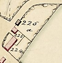
1787:
1838: Pool House and The Green Cottage once three cottages
1886:
2025:
|
|
| TM 1838 Tithe Map: 225: |
OS 1886/1927: 87 |
Name where known: Pool Cottage |
Location 225: |
|
1787:
1838: Pool Cottage.
1886:
2025:
|
|
| TM 1838 Tithe Map: 225a: |
OS 1886/1927: 87 |
Name where known: |
Location 225a: |
|
1787:
1838: a barn and close.
1886: the barn appears to be inhabited and there are more barns.
2025: partly lost to housing driveway and the original barn.
|
|
| TM 1838 Tithe Map: 226: |
OS 1886/1927: 106 |
Name where known: The Closes |
Location 226: |
|
 1787:
1787:
1838: a large close known as the Close in the deeds of Dalkeith as it was part of that property's land. Possessing a large pool.
1887: estate plan for Langton House records this field as 'The Closes'.
1886:
2025: pool has gone and all lost to housing.
|
|
| TM 1838 Tithe Map: 227: |
OS 1886/1927: 86 |
Name where known: Ye Olde Cottage |
Location 227: |
|
1787:
1838: a cottage with a large piece of land extending behind Dream Cottage.
1886:
2025: same but with much reduced garden.
|
|
| TM 1838 Tithe Map: 228: |
OS 1886/1927: 86 |
Name where known: Dream Cottage |
Location 228: |
|
1787:
1838: four tenements.
1886:
2025: now one property with large garden.
|
|
| TM 1838 Tithe Map: 228a: |
OS 1886/1927: 86 |
Name where known: |
Location 228a: |
|
1787:
1838: farm buildings belonging to the adjacent Langton House.
1886:
2025: the farm buildings are now separate dwellings.
|
|
| TM 1838 Tithe Map: 229: |
OS 1886/1927: 86 |
Name where known: Langton House |
Location 229: |
|
1787:
1838: Langton House with outbuilding gardens etc.
1886:
2025:
|
|
| TM 1838 Tithe Map: 230: |
OS 1886/1927: 111 |
Name where known: Coles Cottages |
Location 230: |
|
1787:
1838: known collectively with number 231 as Coles Cottages. This cottage was however detached and larger and possessed closes behind.
1886:
2025: demolished in the 1930s and replaced by modern housing.
|
|
| TM 1838 Tithe Map: 231: |
OS 1886/1927: 111 |
Name where known: Coles Cottages |
Location 231: |
|
1787:
1838: Coles Cottages made up of four tenements.
1886:
2025: demolished in the 1930s and replaced by modern housing.
|
|
| TM 1838 Tithe Map: 232: |
OS 1886/1927: 111 |
Name where known: |
Location 232: |
|
1787:
1838: a close set behind Coles Cottages.
1886:
2025: lost to housing.
|
|
| TM 1838 Tithe Map: 233: |
OS 1886/1927: 111 |
Name where known: Dalkeith |
Location 233: |
|
1787:
1838: Dalkeith, a large Georgian property with farm buildings and garden.
1886:
2025: the farm buildings are now separate dwellings.
|
|
| TM 1838 Tithe Map: 234: |
OS 1886/1927: 139 |
Name where known: |
Location 234: |
|
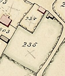 1787:
1787:
1838: a building and close of unknown name or origin. For convenience it is called Rectory Cottage.
1886: shewn as a habitation.
2025: the building has long gone but a sign of its existence is in the boundary wall of the Rectory which at this point is of Blue Lias stone. Now part the the garden of the Rectory. See number 235
|
|
| TM 1838 Tithe Map: 235: |
OS 1886/1927: 139 |
Name where known: |
Location 235: |
|
1787:
1838: a large close with a building that may or may not have been inhabited.
1886: the building appears here to be a habitable building.
2025: no sign of remains and now part of the Rectory garden. See number 234.
|
|
| TM 1838 Tithe Map: 236: |
OS 1886/1927: 120 |
Name where known: Coach & Horses |
Location 236: |
|

1787:
1838: the Coach & Horses coaching inn has been in existence from at the early 18th century.
1886: garden & field behind laid down as orchard and trees.
2025: field lost to housing.
|
|
FOOTPATHS
some survive - some do not.
|
|
Footpaths do not usually have names so we have to rely upon maps. we are or were blessed with a whole assortment of roads, tracks and paths for folk to move about in the parish. In the old open-field system every furlong would likely to have had a separating bulk or track but once the area was enclosed there was probably a greater need for defined footpaths. 'Rights of Way', some long distance, have become established over many centuries but the Bill of Rights of 1689 is believed to have been the first Act of Parliament to fix where one can go without trespassing. Some footpaths are ancient byways but many only exist within the parish. A number of new ways appear on the OS map of 1884 only to disappear in modern times. Our two main paths extend from the parish of Atch Lench in the north, through the centre of the village and on to the river negotiating the bypasses, etc. and down to the river. Marjory Bailey also records long lost footpaths from the days of the Enclosure Act in 1787.


Based on the 1838 Tithe Map.
|
|
|
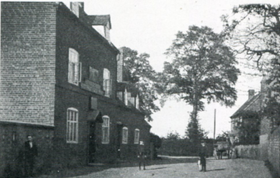
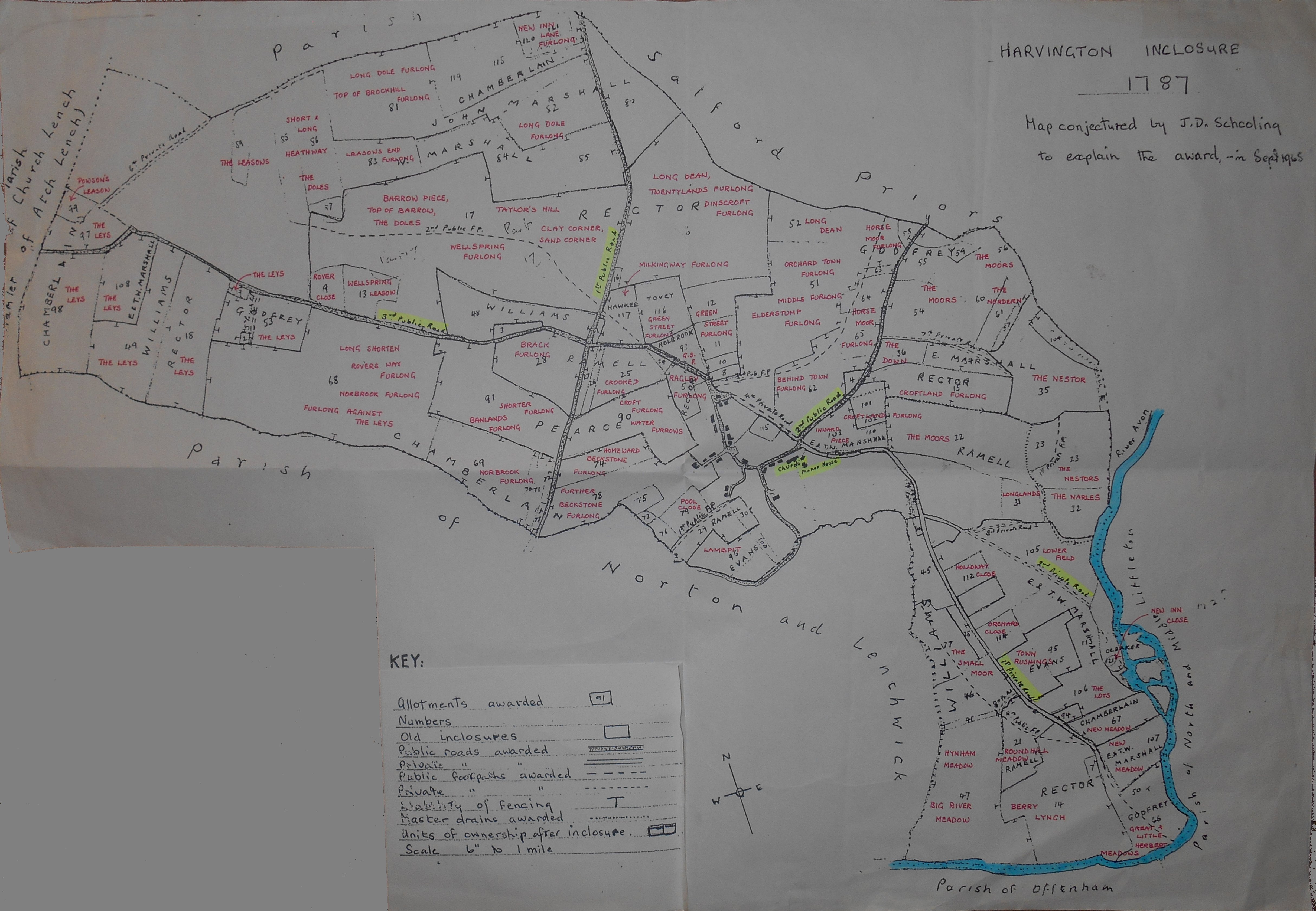
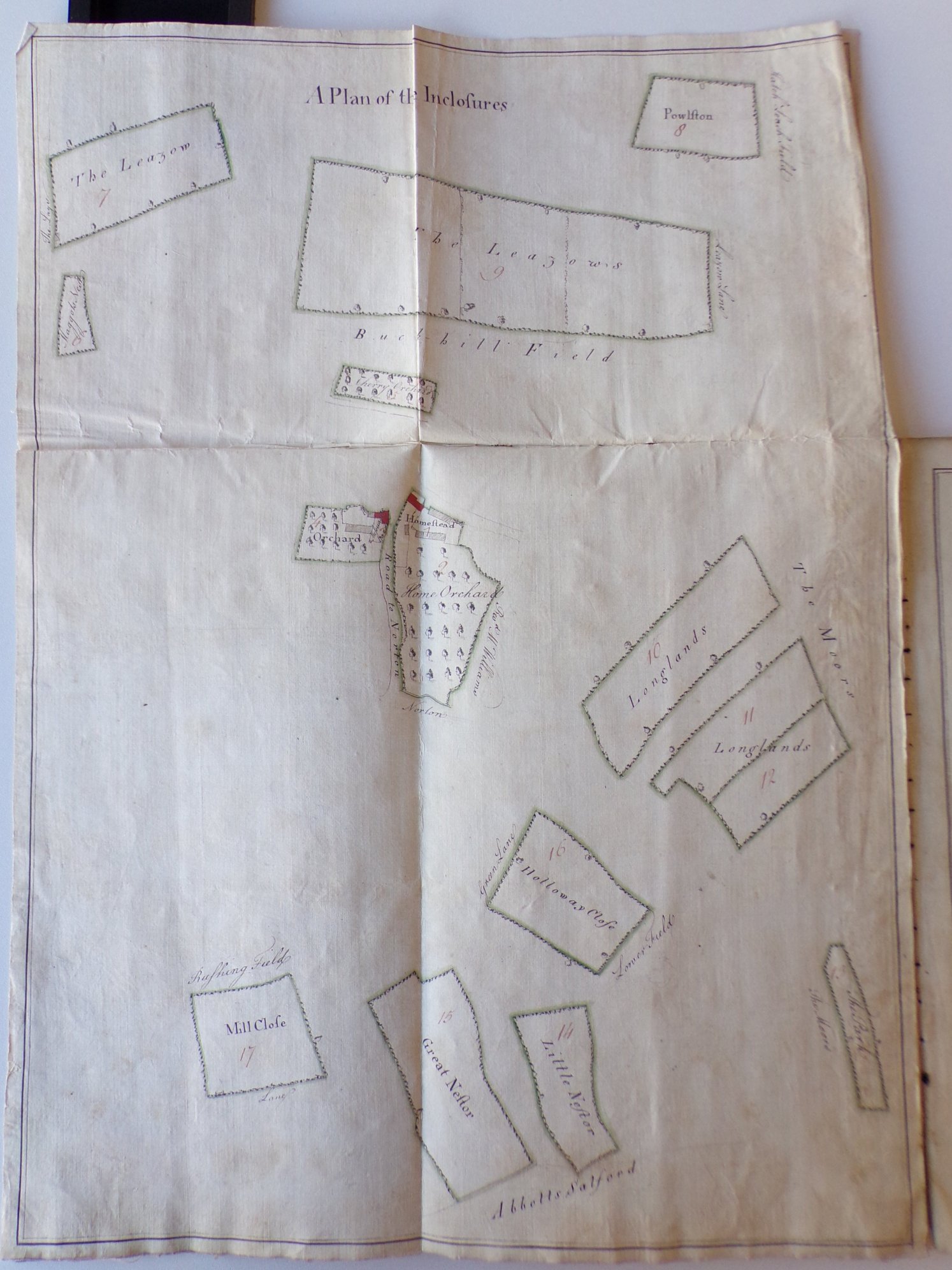
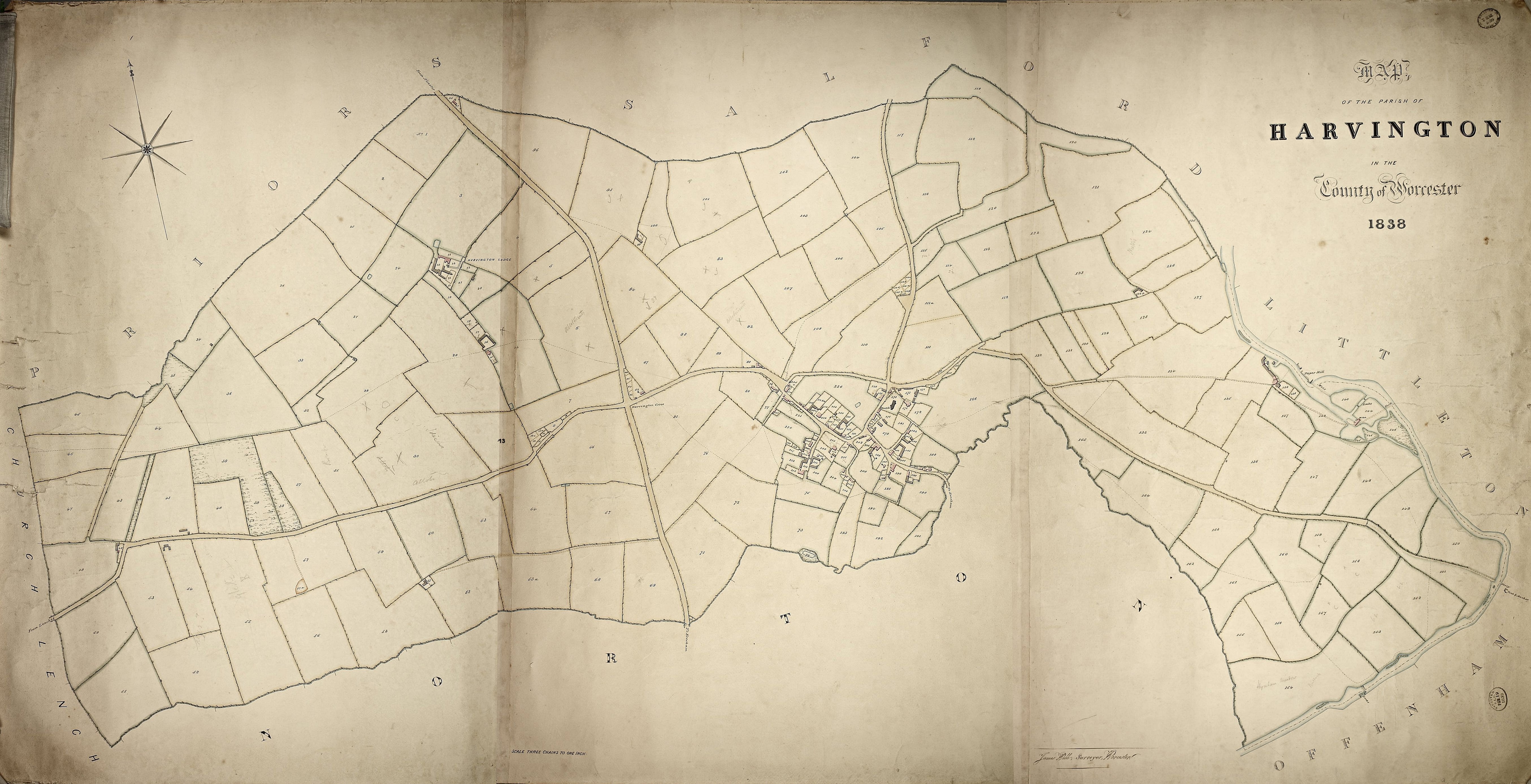


