ASPECTS OF HARVINGTON'S HISTORY
A personal rendering

Coach & Horses
  Home      Booklets etc.      Buildings      Census Returns      Church      Dovecote      Facebook      Families      Histories      Maps       Newspapers       Notes & Queries       PC      People      Pictures      Pubs       School       Sports      Transport      War Time      WI      Contact:   

HISTORY OF

HARVINGTON

from its beginnings

till where this ends


A Bronze Celt


GENERAL INTRODUCTION

This history, or as I call it tongue-in-cheek 'my treatise', started off as solely a history of the very beginnings of Harvington in the Anglo-Saxon period and before, where my knowledge was strongest. The work however has now extended into the Norman period and beyond. Quite how far this project will go is at present dependant on physical and mental stamina. This is an on-going and living project and is subject to additions, corrections, alterations and fine tuning at any time.
Julian Rawes, Crooked Walls 2023.


CHAPTER ONE

PRE-1066 - how old is Harvington?

CONTENTS

INTRODUCTION
Chapter one is my attempt to throw light on the early history of the parish of Harvington and the surrounding area. It is a mixture of the scant archaeological material that we have from the parish and information gleamed from the few precious pre-Norman Conquest documents that survived Viking raids, the Norman invasion, the dissolution of the monasteries, damp and fires.

  1. Occasional prehistoric finds around the village.
  2. The Romano-British site under Blakenhurst.
  3. The origin of Harvington's name.
  4. Anglo-Saxon charters that mention Harvington.
  5. Harvington being once part of an ancient land division in the province of Hwicce.
  6. The transference of Harvington to the Church at Worcester circa AD 799.
  7. Harvington's first known owner Deneberht, Bishop of Worcester.
  8. Harvington's first recorded tenant, a lady called Eanswith.
  9. Harvington's other manor called Wiburgestoke.
  10. Harvington's lost bridge across the Avon.
The first question to ask is what do we mean by 'Harvington', the parish, the estate, the manor, the village: which came first, certainly not the parish, that was only formed as a religious division to serve a community; possibly the estate or manor but then there was at one time two manors; maybe it was the village but there was almost certainly more than one settlement in the parish; maybe the name, but a name needs something in existence to latch on to. Part of our answer is certainly in the name but that is not, as we shall find out, immediately obvious. So, here we go.

The parish extends from the once wooded slopes of the Lenches in the west to the river Avon and the mill to the south. On the east is an unnamed natural ditch and brook utilised as both a parish and county boundary, while to the west is another natural feature, a brook now called Harvington Brook. With the parish's nicely defined reversed L-shape, it gives the appearance of being a stable and long-standing unit. The area on which Harvington is situated is made up of light soil with a heavy mix of pebbles, easy access to water and wood with parts well above the flood plain. This makes an attractive area for mankind to settle, somebody or some people chose well.

Name of Harvington
Place names and their origins is a fascinating study and can reveal an origin that is not obvious from its modern spelling. Place-name study is specialised and one can easily draw the wrong conclusions.

Mostly taken from Bailey's, History of Harvington (see elsewhere on this site), and Mawer's Place-Names of Worcestershire9, here are the following early spellings of Harvington:-

  1. Herverton, AD 709 (spurious 13th century)
  2. Herefordinne, AD 709
  3. Hereford, AD 799
  4. Hereforda, AD 814
  5. Herefordtun, AD 964
  6. Herferthun, AD 1086
  7. Herverton, AD 1227
  8. Hervorditun, AD 1240
  9. Herfertun, AD 1240
  10. Herfortun, AD 1249
  11. Hervington, AD 1508
  12. Herforton, AD 1542
Apart from the first 'spurious' reference, one can see a progression of the name from Hereford to Harvington, a fairly modern spelling and not to be confused with the Harvington in the north of the county, which originates as 'Herwine's settlement'. The original stem of our Harvington is presumed to be the English 'Here' a road where a body of armed men could pass followed by the supplement and self-explanatory 'ford', in this case the Avon ('Afon' in Welsh meaning a river)9. But Hereford can also be interpreted in another way, a translation from the Welsh Henffordd, meaning an old road crossing a river. Was our name originally the British Henffordd, which morphed into English when the settlement became anglicised in the seventh to eighth centuries, or was it of purely English origin? There is evidence that there was originally a settlement down by the river and it was this settlement that would have carried the name. At some stage the settlement dwindled away and the name became associated with the present village a mile to the north.

Roads
A settlement of any kind relies upon a road or track to communicate with the outside world. Harvington has three roads which traverse (or did) the settlement, in our case as through roads. Ageing these roads, or indeed any road, is difficult but nevertheless these through roads need to be taken into account as they have an obvious impact upon the village.

The first is Leys Road, part of Village Street and Anchor Lane (now truncated by the bypass) that runs north-south through the centre of the parish. It is apparently an ancient salt way (one of several in the area), leading down Station Bank, a sunken way, to become Anchor Lane and eventually at one time to cross the river to Offenham. There was once a bridge here in circa1016 (see later). The northern part above Leys Road, takes a route around a brow of the hills and on towards Atch Lench and beyond. A slightly shorter and steeper footpath follows the same direction from the village but ignores the contour and ascents directly up and over the hill, more suitable for non-wheeled transport and therefore perhaps older. Anchor Lane is now of course truncated by two bypasses and there is now no passage across the river Avon.

The next road is the south to north Evesham to Alcester. This is possibly another ancient way which may have crossed the river on the south side of Evesham21. It now crosses the Harvington Brook in a raised section and runs north east passed The Brickyard and on towards Alcester.

The other is the Norton to Bidford road, which originally crossed Harvington brook at 'Carkford', climbed via the sunken ways of the village to join Anchor Lane, descended Cress Hill and on via Abbots Salford, Salford Priors to Bidford. The Domesday records these places in 1086 and it is an obvious link road or track between them.

Archaeology
Until recently there has been very little archaeological research carried out in the parish. Many years ago, on the Harvington and Salford Priors boundary, "a fine bronze CELT" (a prehistoric cutting or cleaving knife) was found. It was 4½ inches (11.43cm) in length, ringed and socketed", and was dated to around 2000 BC. Its present whereabouts is unknown. (Ref:
Bailey's History of Harvington.)

There is a local story that when the Blakenhurst Estate was begun in 1961, a 'small Roman fort' (Castellum) was discovered. The County archaeological Service in Worcester has no record of this find in their Sites and Monuments Record, so it cannot at present be verified. Roman pottery is very distinctive but a fort would suggest something more substantial such as a rectangular earthwork. Before development the land was covered with lengthy gardens stretching back from the houses on Leys. From local knowledge there was nothing unusual about the land, but one notices a distinct rise from Leys road then a flattish area, perhaps something was spotted when the builders moved in. At first glance this seems an unlikely place for a Roman fort, however if the salt way is taken into account, then early on in the Roman occupation there may have been a need for a temporary military fort, as one approached the forest on the Lenches and beyond. Or maybe this was already a British site.

In a recent survey carried out prior to development on two areas adjacent to the Blakenhurst Estate, the County Archaeological Service found parts of a Romano-British settlement. One area was on the south west side of Leys Road, later to become Grove Close, while the larger area was under the Community Orchard and Flood Relief Area. The finds were multi-phase ditches and a small amount of low status pottery plus several pieces of tegula, which are red roofing tiles, usually associated the stone buildings of status. My own investigation in the field adjacent to the Community Orchard, suggest that I was on the periphery of a settlement or farmstead and it is clear from the Archaeologists plans that the site extends under the present boundary into Blakenhurst. The only datable material suggests the latter half of the 1st century AD. On the northern side of Blakenhurst is a fairly deep ditch and spring course separating Blakenhurst and the Romano British site from the rising land to the north, thereby giving both water and drainage to the site. For the report of the Archaeological investigation on the Community Orchard, please use this link, it takes a while to load.

Another story that may be of relevance was the discovery of a stretch of stone walling found during the digging of a pond by the then owner in the late 1960's. The find was in the side garden of number fourteen Brookdale, the adjacent estate to Blakenhurst.

The Almonry Museum in Evesham has a record of Samian Ware sherds, high class Roman pottery, being found in the corner of 'Mr. Coley's field' in 1938. The Coley's owned a number of agricultural plots in the village, in particular the present property 'Oldfields' near to the Golden Cross, built by them in the late 1930's. An area adjacent to Oldfields is being being developed (2022) with no sign of archaeological material. The 'corner of Coley's field' is most likely to have been in the area of the Blackenhurst settlement.

In the 1930s there are also stories that a Roman sword (gladius) was discovered on the south-eastern boundary of the present (2018) allotments near to the school and a Bronze Age axe found near to Green Lane beyond the allotments.

The CAS have also recorded other human activity in Harvington, such as prehistoric crop marks in the area beyond Harvington Lodge, plus a suggestive field name of 'Barrow Piece' near to the Hill Farm ruins. The name barrow usually means there is, or in this case was, a distinctive mound or feature in the area, often indicating the presence of a prehistoric burial mound. See CAS report for details. (Being a PDF, it takes a while to load.) Harvington Lodge stands on a slight hill and commands good views of the surrounding countryside, a favourable position for pre-Roman activity.

Limited spot checking in the old and new churchyard has failed to find any Romano-British pottery. By the ruined mill, a previous notice board commemorating the restoration of the lock, stated that a Roman furnace had been discovered nearby.

Looking further afield there are various sites and find spots in the neighbourhood that give an indication of the density of population in the area. The following have been extracted from 'www.archaeologydataservice.ac.uk'.

  • Salford Priors: Roman coins SP075 516.
  • Salford Priors: Roman pottery 1992, SP079 518.
  • Salford Priors: Roman coins & pottery with dates of AD 337-340 700m east of church SP078 516.
  • Salford Priors: Large coin hoard found in 1811 - 600 gold & 5000 silver in two pits, SP0714 4936.
  • Salford Priors, Marsh Farm quarry, Iron-age and 5th-century Roman settlement/ditch SP078 520.
  • Salford Priors: Prehistoric hut circle/Bronze-age pit/Roman pit & field boundary 1993, SP08100 52800.
  • Abbots Salford, quarry: Roman settlement/corn-drying oven, topsoil observation SP07200 49300.
  • Dunnington: Iron-age settlement.
  • Bevington Waste: Enclosure SP044 539.
  • Twyford: Blayneys Lane, Roman settlement 1954, SP04500 45800.
  • Fladbury, Ferndale, Chequers Lane: Roman feature SO99560 46060.
  • Offenham: 2nd & 4th-century Romano-British pottery, traditional site of Mercian Royal Palace SP0564 4644.
  • Offenham: possible site of Roman Villa SP0574 4546.
  • Norton, Leylandii House Farm: Roman farmstead hut circle & Romano-British structure, corn drying kiln & ditch. Reburied and preserved 405600 248400.

The nearest proven Romano-British settlement/farmstead outside Harvington is on the other side of the bypass in the parish of Norton near Leylandii House Farm. This was excavated in 2022 but details have have yet been written up. Another perhaps important site listed above but not excavated properly, lies adjacent to Blayneys Lane. There is a Roman site on a hill above Offenham, where a collection of bronze spoons was found a few years back and reported to the museum at Worcester, and of course there is the crossing of Icknield/Buckle Street at Bidford with Roman material being discovered in a nearby field. There was also a lengthy story relating to a major hoard of hundreds of gold and silver coins found in the field between Cleeve Prior and North Littleton. They had been purposefully hidden in two jars under a large stone. Clearly the person who hid them and never returned had considerable wealth at his disposal.36

The Settlement at the Ford
It is believed that the original site of Harvington was down by the river. There are at least two reasons for believing this: one is the name being originally Hereford, with the emphasis on the ford; the other is a raised area near to Mill House where an aerial photograph taken in 1953, indicates a circular enclosure along with crop marks, although there is a possibility that these may be prehistoric. A settlement however was most likely to be in this area as it is adjacent to the mill. It is however away from the river crossing a few hundred yards away between the end of Anchor Lane and the Offenham Road across the river and nearby to the Fish & Anchor.


From the Almonry

The traditional settlement spread among the British or Celtic population was of scattered farmsteads and this was originally probably the case for the English. Towards the latter part of Anglo-Saxon period however there was a trend towards settlement nuclearisation into villages. Della Hooke suggests that when we look at the English word tun/ton we see that originally this would have applied to estates or later parishes and only later was it applied to the village itself. There is also a tendency to find British settlements on the higher ground, with the English preferring more low-lying areas. This may represent the situation in Harvington. The original focus of a settlement other than the area around the ford, is on the higher ground, probably in the vicinity of Harvington Hill where it offered clear views of the surrounding countryside. Crop marks, a barrow and the nearby Romano-British settlement, does this hold a memory of the original British settlement with the English co-existing down at the ford or had the British settlement ceased to exist by the time the English had arrived? Deerhurst near Tewkesbury is an example of co-existence. An early English Christian foundation, by the River Severn and on a hill within one mile is the hamlet of Deerhurst Walton, Walton meaning 'Welsh'. There are fascinating possibilities here in trying to understand the situation as it existed some fourteen hundred years ago.

Historical Background
To give a sense of depth to our history of Harvington a possibly useful exercise is to speculate on our area before the Romans invaded Britain. From the onset there is a good deal of speculation here in attempting to place Harvington within a pre-Roman political context. Harvington's later political place in the area will be discussed in a subsequent section.

Celtic Period
One of the consequences that resulted from Julius Caesar's invasion of Gaul, completed in 51 BC, is that it sent shock waves not only across Gaul but also its effect on Britain. Several Belgic tribes migrated to Britain, one was the Atrebates who were a group based around the modern northern French town of Artois. After the Atrebates were defeated in Gaul Caesar appointed one of their number Commius as king, however this was not successful and he later fled to Britain with followers and established a new Atrebas kingdom in Southern England. The above may or may not be relevant depending on the origins of the
Dobunni, who are relevant to us as they probably controlled this area.

Some authorities suggest that the Dobunni were another Belgic group who fled Gaul and may have been aligned with the above Atrebates, while others suggest they were connected to the powerful Catuvellauni to the east. In any case their base at Bagendon near Cirencester and it is from this base that, in the last decades of the first century BC, that the Dobunni expanded rapidly, south and west into Wiltshire and Somerset, east into Oxfordshire and, more importantly for us, northwards into northern Gloucestershire, parts of Worcestershire, Warwickshire and Herefordshire. This Dobunni expansion almost certainly engulfed the Harvington area. It may be significant that at this time one of the hillforts on Bredon Hill was taken by storm.24 The distribution of Dobunnic coins (staters) are helpful and have been found in Evesham, Childswickham, Dunnington, Alcester. Bidford-on-Avon, Bredon Hill, Badsey, Cleeve Prior, Welford-on=Avon, Rous Lench, Wixford and further afield.48

Between AD 33 & 43, coinage evidence, indicates the Dobunni were ruled by two kings Anted and Eisa. At their greatest expansion the new empire appears to have been divided with an east-west line based roughly on the Stroud area in mid Gloucestershire. Coinage distribution suggests that their rulers, Catti and later Corio and Comux, held sway to the south from circa AD 43 and 47 while Bodvoc ruled over the northern sector, it is the northern sector that interests us here. These kings or chieftains, possibly Anted & Eisa and certainly Bodvoc, are the first named individuals we have who most likely had influence over this area.


Dobunni coin of Bodvoc

There are a couple more, albeit scanty references to Dobunnians that come down to us: a tombstone at Templborough in South Yorkshire dedicating Dobunnian Rufilla whom Excingus, her husband, had met at Cirencester; the other is a Dobunnian called Trenus who's son Lucco was given a diplona appearing on a stone found in Pannonia, issued to him in AD 105.51

The General, Aulus Plautius, under the Roman Emperor Claudius, landed on the south coast of Britain in AD 43 and received a number of submissions from British rulers. While Aulus Plautius was in Kent, he appears to have received the submission of Bodvoc, king of the northern Dobunni and at this stage Bodvoc and his realm probably became a semi-independent or client kingdom. We do not know the effect the Roman invasion had on this area but if we are right then it would have been less dramatic and life for while may have continued as before, however we simply do not know.

In AD 47 Aulus Plautius was replaced by Publius Ostorius Scapula as Rome's second Governor of Britain. He immediately set about campaigning against the British and established a forward base at Glevum (Gloucester). The southern Dobunni resisted but it appears that the northern Dobunni did not as their capital at Bagendon when excavated didn't shew any sign of war damage. Bodvoc may have been replaced by a Roman official or more likely continued as the Dobunni's leader under the watchful eye of the governor. Nearby Cirencester was established as the administrative capital of the Dobunni circa AD 50-60 under the name Corinium Dobunnorum. Cirencester eventually became a regional capital of the Roman province of Britannia Prima and one of the largest towns in Roman Britain. Meanwhile Bagendon was abandoned and slowly disappeared from history until it was excavated by Mrs Clifford during 1954-56.24
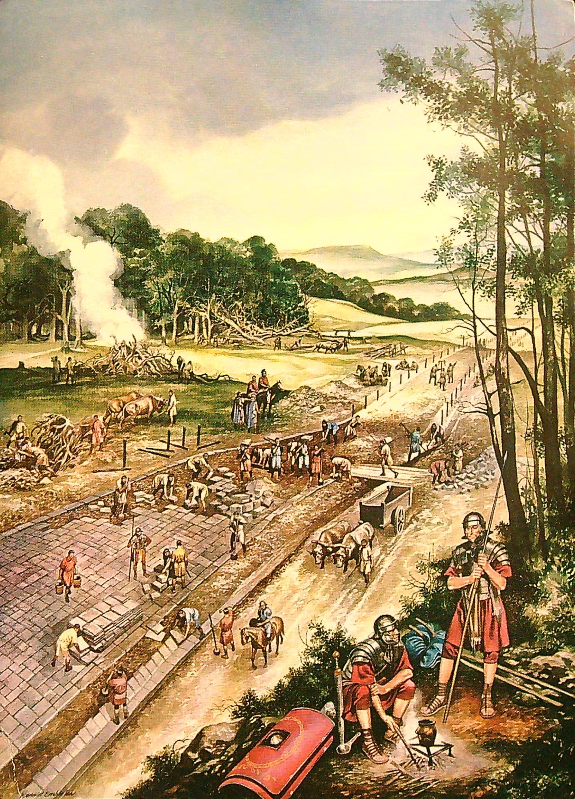
Roman Period
For the succeeding two hundred years Roman Britain was wealthy and stable and by the time of the Emperor Constantine by AD 314 Roman Britain was divided into four regions, which with its own political administrators and Christian bishops. The province had suffered serious barbarian attacks from the mid-3rd century onwards, which prompted the establishment of a navy (Classis Britannica), setting up of the Saxon Shore forts and the introduction of 'friendly Saxons' (federatii) and their families to help defend the country. This had been a policy on the German border for a considerable time, however in AD 367 Roman Britain suffered a concerted onslaught from all sides with raiders from Ireland and Scotland along with Franks and Saxons from the continent, which devastated the country. The wealth of the province had been concentrated in the undefended rural Roman villas and as they were wealthy they probably bore the brunt. The raiders were driven out by the Roman army under Emperor Theodosius and order was establish, but the province never fully recovered. The local effect is not known but there were estates in the area such as a probable villa at Salford Priors and certainly a number of villas across the river Avon. It was after these raids that many of the wealthier folk probably moved into the towns like Alcester for protection. Many towns were fortified at this time and probably garrisoned, again probably by friendly Franks and Saxons etc. The villa estates and countryside probably continued to be farmed as before under much the same centralized structure albeit without so much grandeur.

Governors came and went until in AD 380 Magnus Maximus was appointed governor, it is probable that it was he who reorganised the western defences, particularly in Wales where he was remembered and much loved in early Welsh literature. Whole peoples were transferred to north and mid wales to stave off attacks from Ireland. Magnus Maximus assumed the title of emperor of the Western Empire in AD 383 and apparently took parts of the Roman army from Britain to support his ambition - he was killed in AD 388. A biography of him has been written by Maxwell Craven who describes the situation in Britain in detail.51

British Period
For historians and archaeologists there has been a sharp divide between the Roman period and that of the Anglo-Saxon depending on their expertise, separated by the so called 'Dark Ages', but now more usually 'Post Roman' period. This has now changed as our knowledge grows both in archaeology, studies of ancient charters and place names etc. Clearly some Romano-British towns and hundreds if not thousands of small settlements ceased to exist, but many continued, slowly changing over the centuries and acquiring Anglicised or English names. There have been major swings in the historian's and archaeologist's way of thinking between the English sweeping the poor defenceless British into the sea to hardly any English arriving here at all, just a few war bands. The true picture has to lie somewhere in between depending on the locality. The inexorable decline of Roman Britain in subsequent years is to be found in the last chapter of Keith Branigan's book on Roman Britain.49describes the gradual decline coupled with the survival of an independent British state.

After AD 410, a more or less unified Roman Britain continued with its own governors/kings/dictators such as figures like Ambrosius and his son Ambrosius Aurelianus and Vortigern. Much has been written about them, especially Vortigern; Ambrosius Aurelianus is mentioned by Gildas and therefore deemed a more historical figure; while Vortigern is only mentioned in early Welsh historical texts therefore his existence is deemed less reliable. Vortigern is written as local to Kent because of his dealings with Hengist and his people, Gloucester because his father Vitalis is believed to have been from there, or North Wales because that is thought to have been where he died. It is certainly possible and likely that he was an historical figure and was a ruler of Roman Britain as a whole, whether as a usurper or not.51

Vortigern is given the blame for hastening the disintegration of Roman Britain. This point is strengthened with the story that Vortigern introduced peaceful Jutes into Kent by giving them Thanet as a payment for helping to defend the eastern coast. This apparently backfired when he either refused or could not pay the new settlers, they rebelled and so started a process that eventually became unstoppable. In consequence of infighting and the mass movement of new peoples, the central authority of Roman Britain fractured into many different kingdoms fighting for supremacy over both their British neighbours and the incoming English. All this would have led to death or displacement for the ruling classes and huge disturbances and suffering for the ordinary folk, some of whom would have no doubt profited from the chaos, while others trying to keep a low profile and carry on everyday life as they knew it.49 Somewhere in this gloom there is the 'legend' of Arthur.

An interesting point made by Guy Halsall in his book Worlds of Arthur, suggests that long contact between peaceful Saxons establish here to help defend the more Romanised elements of the country may account for the number of Latin loan words in Old English.40 The British ruling class may have succumbed to a greater extent, but the ordinary folk probably continued to live out their lives, albeit gradually being absorbed and learning to speak English. Whereas as far as words from British is concerned, although many British geographical place names survive, it is to be noted that there are virtually no British (Welsh) words in English. A telling and rather chilling detail, is that while the British called themselves Cymbri, the English referred to the British as Welsh, meaning foreigner or slave. It is not often realised but Roman Britain was supported by a 'slave economy'. This was a must for the maintenance of the great villa estates and the incoming English would have been only too happy to continue with this practice. Just replace the boss and one has a ready-made income! The slave system was only abolished with the incoming of the Normans, only to be replaced by the feudal system - slavery by another name. Another element is the intermarrying between the British and English in the forging of alliances etc. The early West Saxon rulers had British names which suggests a far more complicated situation than the written history such as the Anglo-Saxon Chronicles describe.

During the fifth, sixth and seventh centuries many of the British kingdoms were either absorbed, evolved or replaced by English kingdoms - sometimes dramatically, sometimes by a gradual tipping of the balance from British to English. At the same time the English were also warring against each other and vying for supremacy, a dog-eat-dog scramble for dynastic land and power where many and eventually most of the early tribal groupings, war bands or small kingdoms became subordinate and then absorbed into larger kingdoms before finally disappearing, often leaving just a name for us to know they once existed, such as the Shottingas centred around Stratford upon Avon.

As far as the Harvington area is concerned a most interesting element to these rather distant events in space and time is that the area controlled by the Dobunni with their capital at Bagendon, corresponds very nicely with the later Mercian province of Hwicce. Is there a hint here of a Celtic then Roman province surviving into the post Roman British and English world? After the Romans left and any central British authority collapsed, Cirencester may have continued as a much diminished regional capital or independent post-Roman kingdom until it was conquered by the West Saxons in AD 577.

Roman and Post Roman land divisions
In pre-Roman times this area was possibly under the control of the Dobunni, a British tribe with their capital at Bagendon near Cirencester. Virtually no local land divisions such as estates, parishes, hundreds or counties are known from before or during the Roman period. It is likely that, at least initially, major tribes like the Dobunni, kept their smaller land divisions after the Roman conquest1. It makes more sense for the conquering power to take over an existing economy and the northern Bobunni who may have submitted to the Romans in exchange for a degree of independence and continuation. Birley in his work The Roman Government in Britain writes: "The Commonwealth (Respublica), presumably of the Dobunni, is mentioned on a fragmentary stone from their chief town Cirencester".42 Is this a faint suggestion of the existence of divisions of peoples with corresponding areas? In the late Roman period Roman-Britain was divided into four administrative regions which in themselves would have had sub-divisions, probably based on a pre-existing tribal system. We were in the administrative provence called Britannia Prima, possibly governed from Cirencester, a stone found at Cirencester records one of our governors as Lucius Septimus of the 'Remi' area in Gaul.


Administrative divisions in late Roman Britain.44

The above map shews the major late-Roman political divisions in Britain, but it does not of course tell us any more about the smaller administrative areas, except an indication of tribal areas of influence. The Roman land divisions were controlled from a central administrative town/city called Civitas, such as local Cirencester, Gloucester and later Alcester. Colonate/colonus/coloni is a late Roman system of territorial holdings for the folk in late Roman times, which roughly equates with and possibly a forerunner of villanage/village/villager.47. Welsh land divisions may be of help here but of course the development of the Norman feudal system has a role to play, in itself a product of late Roman and early Frankish developments. It is now gradually becoming apparent that some smaller Romano-British land divisions, such as estates, may have survived after the coming of the English and then to slowly change over time such as property boundaries do now. As a side issue, here is a very nice, if perhaps over enthusiastic, description of Roman Britain written circa AD 310.


A panegyric on Britain written in AD 310,
following the coronation of the Emporer Constantine,
from Panegyrici Latini, Mynors, Oxford 1964.44

David Cox in his The Church and Vale of Evesham, gives a tantalising glimpse of large local Romano-British estates that may have survived as units from Romano-British times only to be divided into smaller units in middle or late Anglo-Saxon times20; one such case study was an estate based on Murcot and covering Wickhamford and Childswickham, another possible Romano-British estate may have been centred in Twyford, covering Evesham and Norton and Lenchwick. Finburg28 suggests a Romano-British estate which included Batsford and Blockley, governed from a Roman settlement at Dorn on the Fosse Way. Finburg also mentions a charter dated to the late 7th century in which an estate at Henbury by the Severn Estuary in Gloucestershire as having 'ancient boundaries', an evocative description suggesting age. Finburg makes a powerful case for a major Romano-British estate based at Withington in Gloucestersihre, which he believed survived into the Anglo-Saxon period and beyond. Closer to us it is very likely that there was a Romano-British estate based at Salford with its villa now under the A46; also another across the river in the Littletons. There are tantalising possibilities here, or is continuity to this degree wishful thinking?

Were there property divisions in Harvington and did its Romano-British population, which is now known to have existed, survive to fuse with the incoming English? Did the surrounding British control centres at Alcester, Worcester or Winchcombe have any impact or governance over the Harvington area after AD 410. Because of its position, hemmed in by the Lenches and forest on one side and the River Avon on the other, a likely candidate is the Romano-British town of Alcester. It is possible that the British in the region enjoyed over 150 years of relative (with a strong emphasis on relative) peace before the English arrived in force.

Around the AD 530/40s, while this area was still under British control, there were two major events that took place. In AD 534 there was a large volcanic eruption in Iceland which sent a pall of ash across the northern hemisphere. The result was a failier of crops for a year or two resulting in famine. The second event around the same time was an outbreak of plague, similar to the Black Death. These two events would have had a major effect on Britain whether British or English.

Cædwallan's Fortification
Cædwallanbyrig (Cædwallan's Fort) is mentioned in an unattached boundary clause (Hooke 68) concerned with the holdings of Evesham Abbey. The fortification (SP 021 475) is believed to be a small hill top situated above Wood Norton just to the north of the larger Tunnel Hill above and to the north of a low-lying hamlet called Chadbury. The hamlet is named after someone called Cædwallan and was given to Evesham Abbey, apparently in or around AD 703. The fort guards the pass and east-west route hemmed in by the Lench hills to the north, the river Avon to the south and the area (Twyford) to the east. Prince Edward, the future King Edward 1st, took this route to the Battle of Evesham in 1265. The identity of this Cædwallan is not known. He carries a familier British name so was he the last British ruler defending this area, possibly in AD 577 against the West Saxons from the south east; or was he a ruler of mixed West Saxon and British extraction (several West Saxon kings possessed British names), defending the area against the Mercian's under Penda in the AD 620's from the north east?

Conquest by the West Saxons
In AD 577
Ceawlin king of Wessex, defeated23 three British kings, Conmail of Gloucester, Condidan of Cirencester and Farinmail of Bath, at the battle of Deorham13 in southern Gloucestershire. We have no idea how much territory these three British kings had influence over or how far north from Gloucester Ceawlin penetrated and it is possible that he was simply seeking tribute from rather than outright conquest of the British32 although there may already have been peaceful settlement in Hwicce prior to AD 577. A linguistic divide in place names has been noted with a West Saxon element to the south and east and an Anglian element to the north and east, particularly along the Oxfordshire border. We simply don't know how large was the West Saxon settlement in Gloucestershire and beyond but in any case there was probably also pressure from Anglian and Middle Saxon groups filtering in across the Cotswolds from the Thames Valley. This is suggested in the the difference with linguistic elements between the West Saxons to the south and Anglian elements in the est and north of Hwicce where .

The West Saxon influence or power in the area was relatively short-lived as fifty years later, in AD 628, the great Mercian warlord Penda was on the march southward from present day northern Warwickshire, as the Anglo-Saxon Chronicles record that Cyngils and Cwichelm his son, King of the West Saxons, fought Penda at Cirencester. They came to an agreement and henceforth Penda was the dominant power in this area known or soon to be known as Hwicce .

Alcester
Alcester is the nearest known Roman town to Harvington. There was a small walled fortlet (castellum) here, possibly built circa in AD 47, and the town started to develop afterwards being near the junction of the north-south Icknield Street and the east-west Droitwich to the Foss Way. It became a Colonia called Alauna, derived from the river Alne which flows nearby, see https://en.wikipedia.org/wiki/Alcester. There is a local British hillfort which is believed to be the forerunner of the town. A stone town wall was built shortly after after AD 364.43 Its name survived into the English period and it or rather its people appear in the Tribal Hidage as the Arosæte, to be discussed later. The fact that its name includes 'cester' suggests that in the fifth & sixth centuries, and probably later, it was the centre of an administrative district or area. At this time it is not known whether its rulers were British, English or a mixture of both but it came under the sphere of the English Penda sometime just before AD 628. After the building of Ecgwine's church at Evesham circa AD 709, endowments of that house were confirmed at a synod held at Alcester by Bertwald, Archbishop of Canterbury and Wilfred, Archbishop of York. According to the legend of St Ecgwin, the then Bishop of Worcester, who went to Alcester and found the town peopled with smiths, who refused to listen to his preaching and attempted to drown out his voice by the sound of their hammers and anvils.41 Della Hook suggests there may have been tension between the British Church and English Church, which also suggests that Alcester may well have had a surviving British presence in the town. Be that as it may this does suggest that the town was not only Christian but deemed a suitable place for such a meeting. Alcester is important to us as it is possible that Harvington, was at one time within the town's jurisdiction. This will be discussed later on under 'Hundreds'.

The Hwicce
From at least circa AD 650 to the early 11th century Hwicce was one of the provinces of Mercia, initially as a semi-autonomous entity with under-kings and later as a division or province under earls. Judging by place names and later documentation16 the fullest extent of Hwicce encompassed a large area from Kempsford in Gloucestershire to Bridgnorth in Worcestershire, Bath in Somerset to Whichford in Warwickshire, which obviously included Harvington. But this was after it became an established province of Mercia under its own English rulers.

The first mention of Hwicce is in the mid-7th century by which time it was under the yoke of Penda of Mercia and apparently controlling a number of once independent areas such as Worcester and Alcester and maybe the Husmeræ, Stoppingas, Wixna, but unfortunately there is no record of its origins.

There are vague indications 17,28 that Hwicce, or more usually The Hwicce, a possibly British name, was originally a British Christian Kingdom that had retained a degree of stability. Bede22 in the early 8th century makes no mention of an invasion or conversion of The Hwicce, which is thought to imply that the area was already nominally Christian. There is also a higher percentage of British names surviving in Gloucestershire than in other areas in Mercia31. There are also indications16 that its early epicentre may have been in Winchcombe in Gloucestershire, an old wealthy and settled Romano-British area with suggestions of continuity between Romano-British and later English property divisions such as at Withington28.

The coming of the English
There have been huge advances in the study of place names and what they tell us. As the Anglo-Saxons moved westwards across the country, passage of time enabled them to make ever more contact with the British, so naming patterns change and surviving British names become more frequent as one travels westwards. The suggestion is that the English arrived in this area as a political force relatively late in the 6th and early seventh century9 either as wandering settlers or by dramatic and sudden raids on or conquests of established British kingdoms.

It would appear that this area and the wealthy lands on the Cotswolds and Severn Valley to the south might have succumbed to political takeovers, whereas to the north and east, into the present day Warwickshire, folk movements appear to be the norm. It is these quiet folk movements that from the east and north east that probably tipped the demographic balance in this area between the British and English speaking peoples. The Tribal Hidage and place names are a great help here in giving faint signs of a patchwork of once existing peoples, such as the Pencersætan, south west of Birmingham; the Husmeræ based on the river Stour; the Stoppingas, around Wootton Wawen and the river Alne; the Feþþingas14, a Middle Anglian folk north east of Worcester; the Wixna, a Middle Anglian people. Collingwood and Myres in their book 'Roman Britain and the English Settlements'2, suggest that a group of the Wixna settled to the north of here:-

Midway between Worcester and Stratford is a small stream, still known as the Whitson Brook, that recalls a settlement here of the Wixna, one of those mysterious Folk of the Tribal Hidage, who soon lost their identity in the formation of larger political units. In the Tribal Hidage the Wixna appear already divided into an eastern and a western group, and while their position suggests that their original homes were in close proximity to the Gyrwe and Spalda of the north-western Fens, it by no means impossible that one branch had migrated at an early date up the Welland and so across the easy watershed and down the valley of the Warwickshire Avon. It may be that this division is itself recognised in the distinction of the East and West Wixna; their appearance in Worcestershire is in any case an excellent illustration of the Anglian element already evidenced in the archaeology of the Avon Valley.

These, except perhaps the last mentioned, were probably family groups setting out either as war bands or simply as settlers. Archaeological research in recent years has shown that pagan Anglo-Saxons started penetrating this area in the mid-6th century. Across the river Avon on Bennetts Hill in Offenham parish was discovered a pagan Anglo-Saxon Cemetery. It was excavated in 1996 and dated to the 6th and 7th centuries. They were likely to have been a mixture of mostly Middle-Angle and Middle-Saxon war bands and settlers. Finberg writes 'In all probability the English invaders were in their eyes colonists, similar to the backwoodsmen in North America only to be followed by more organised warbands with a view to taking over'. The British of course would have seen all these newcomers in a very different light. Some of these groups based upon old Roman centres such as the Arosæte at Alcester and the Weorgoran at Worcester, may have been British, clinging on by paying tribute to the advancing English. It must be born in mind that it was not simply English against British. Both peoples were just as likely to raid and take over neighbouring groups of their own kind, often with help from the other side.

Penda and the Tomsætan
Penda is the first ruler to have definitely had an effect on this area when he swept through and from henceforth, whether British or English, Hwicce came under the sway or influence of Penda and his successors, so it is thought worthwhile dwelling on him for a while.

Penda, is believed to have been a ruler of the folk called the Tomsætan, based in the area surrounding Tamworth, dwellers of the Teme Valley. He was born sometime around AD 590-600 to Pybba. Pybba, who commenced his reign in AD 593 and possibly died in either AD 606 or AD 615, had amongst others two sons, Eowa and Penda. This was a time of Tomsætan expansion, more often than not against other English groups. Eowa and Penda ruled together and their expansion was in all directions, they had a powerful neighbour - the English Northumbrians and had much ado keeping them at bay. Their success was dramatic and within a few years they had created an empire to be known henceforth as Mercia, in essence they were warlords in its full sense. For our region the crunch came in the AD 620's when Penda and his marauding army cut a swathe through Hwicce all the way down to Bath and Cirencester in southern Gloucestershire where in AD 628 his expansion southward was checked by the powerful West Saxons. The provinces or kingdoms caught up in his campaign, whether, British or English, either disappeared or had to pay tribute.

Eowa and Penda's joint campaign culminated in the great Battle of Maserfield in which the Mercians and the British of Gwynedd joined forces defeated and killed the saintly Oswald, king of Northumbria in AD 644. There is an odd mix here of Pagan Middle Angles and Christian British fighting against Christian Northern Angles which illustrates the complexity of the situation as opposed to simply pagan English and Christian British having a go at each other. Unfortunately for Eowa, he was also killed in this battle and Penda became sole ruler of Mercia. Penda finally suffered a crushing defeat by Oswiu of Northumbria, and was killed at the Battle of Winwæd on 15th November AD 655. Penda was one of the last pagan kings of the English, times were changing and so were the English.

At some stage in the late AD 620's Penda must have set up or taken over some form of structure whereby the various provinces he had subdued paid taxes or tribute and very soon after Penda's death in AD 655, Hwicce appears with a ruling dynasty under the brothers Eanhere and Eanfrith. It is curious that Eanhere and Eanfrith, and their offspring, held Northumbrian names and Eanhere's wife Osthryth was also Northumbrian. Were these brothers part of Penda's extended family or a couple of disaffected Northumbrians or younger siblings of the Northumbrian royal family who had joined Penda's warband, if so they did well for themselves. The peoples they ruled though would have been a mixture of West Saxons, Middle Angles, Middle Saxons, Northern Angles and of course the native British. They soon established their spiritual capital at Worcester and as a kingdom then a province, then county or region of Mercia and remained an entity until the early 11th century when the present county system was established and blew it away. The AD 620's was probably a troubled time for anyone living in Harvington but by the AD 650's the situation seems to have became more settled.

Harvington's first recorded leaseholder is Eanswith in AD 802, the similarity of her name to the rulers of Hwicce is again suggestive of a family connection.

The Tribal Hidage
This is the oldest surviving Old English document to give a hint of the local situation. It is an early English tax document and is believed to be Mercian or mostly concerned with Mercia. The likelihood is that it was created for one of the 7th century kings, probably a Northumbrian, while they were partially in control of Mercia between the years AD 656 to AD 675. The document establishes the taxable value of the various client kingdoms within Mercia's realm of influence. The document is a good indicator that the English already had a system for raising tax or tribute. This implies land ownership, boundaries, knowing who owned what and where. Another point is that this is a tax document not a racial one, some of the groups, such as the Weorgoran or Arosæte, may well be essentually British paying tribute, the population was probably very mixed at this stage.

There are three names on the Tribal Hidage that are especially relevant to us: Mercia proper, (with 30,000 hides), based at Tamworth; the Hwicce, (with 7000 hides) who may have been centred for a while in Winchcombe (but later Worcester); the Arosæte, (with 600 hides) who were based in the Roman town of Alcester (Latin: Alauna).

It is interesting to note that when the document was produced Mercia proper, the Hwicce and the Arosæte were taxed separately. We also do not know where the boundary between Hwicce and the Arosæte was so we cannot say for sure who controlled Harvington.

An interesting factor is not just the folk mentioned but the folk who are not mentioned: the Weorgoran (Worcester), the Stoppingas, Pencersætan, Huckerie, Wixna, Tomsæte (Tamworth), Beormingas (Birmingham), Husmeræ (River Stour). It is likely that at the time of the Tribal Hidage, some would have been taxed within the Mercian realm while others like the Stoppingas were more likely to have been taxed within the sphere of Hwicce, as they had at one time paid food rent (Tribute) to Hwicce27.

Sætan meaning 'a resident inhabitant holding of land'34.

Christianity
In Britain, as in the Empire, there was almost total freedom of religion with a multitude of faiths and creeds provided politics was avoided. The three religions that caused political unrest were Druidism, Judaism and Christianity. Christianity had been present in Britain from at least the 2nd century, probably mostly in Roman towns and cities. The Christianising of Roman Britain took place over a considerable period. Christianity was given a huge boost in the early 4th century under Emperor Constantine the Great (AD 306-337), when he declared Christianity the official state religion. There were powerful forces and individuals abroad and the struggle between Christianity and paganism and the powerful individuals involved tore the Empire apart. Archaeologist have found secret rooms in villas dedicated to both pagan and Christian beliefs suggesting many people were caught out and suffered the consequences as the political and religious pendulum swung back and forth with corresponding hatred and viciousness; St Alban as of St Albans, who was a soldier, tried to protect a Christian priest in Verulamium called Amphibalus and was consequently tried and executed. Hypatia (died 415) of Egypt, a renowned pagan philosopher, astronomer and mathematician was torn to pieces by a mob of enraged monks.

By AD 316 Christianity had become established enough to set up a recognisable church structure with bishops and dioceses centred on cities. This was the case in Gaul and there is no reason to believe that Britain was any different. From these days we still use the Latin words diocese, bishop, rector, priest and vicar.

By the time of the great Council of Arles in 314, there appears to have been the embryo of a Church structure. Three Bishops and two clerics represented Britain at the Council. Sometime in the 4th century Roman Britain was divided into at least four, six or even more dioceses, each lead by one or more bishops. Bishop Restitutus of London, Bishop Adelphius, very likely of Lincoln, Bishop Eborius, presumably of York took part. They were joined by two clerics, a deacon called Arminius and a priest called Sacerdos, which possibly represented one or more bishops of the large south and south-western province (Britannia Prima), which included our area.51

The Church had won the battle over whether to co-exist with other religions and banned all other pagan faiths and then settled down to arguing over what type of Christianity the Church wanted. There were the Donatists in North Africa over the division between church and state. Relevant to Britain was a major rift over 'original sin'. The main protagonists were Palagius (died AD 418), and Augustine of Hippo (AD 354-430). Palagianism was particularly popular in Britain as Palagius, was born and presumably educated in Britain before moving to Rome. Augustine won the day and Palagius was posthumously declared a heretic.

By the AD 440s however the world in Britain was changing dramatically and not only the Church but the country was in trouble, the English were here but not as yet in control, forces were gathering which would almost destroy the Romano-British Church and its world. In the mid-fifth century two British Bishops emigrated to Brittany they were called Mansuetus & Riocatus. Mansuetus attended the council at Tours in AD 461.44. Seventy or so years later we have the writings of Gildas, a monastic Christian who wrote on the state of Britain and the corrupt grim British rulers governing it, he didn't think much of the English either!46 He too eventually emigrated to Brittany. From the above there is clearly a strong presence and structure of Christianity in Britain. The main reason for writing the above is to get an idea of the administrative structure of Christianity in Britain and ultimately in this area and to a great extent I have failed - we know so little.

Local Christianity
Christianity is believed to have survived within the Kingdom of Hwicce from Roman times, thereby suggesting a degree of continuity. There are signs of the British with an early Church at Gloucester. The Venerable Bede in his book The Ecclesiastical History of the English People in AD 731, fails to mention any conversion of the Hwicce. He also states that Eabe, daughter of Eanfrith, was baptised circa AD 660 "in her own country" (Hwicce) and Eanhere's son Osric was interred at Worcester in AD 685. After the English takeover, the area probably became an assortment of Christian and pagan enclaves, Gloucester, Alcester, Worcester and indeed our area was probably nominally Christian, whereas the areas to the north east in Warwickshire shew signs of paganism, certainly Penda and the Tomsæte were pagan. England is recorded as having a relatively peaceful conversion while the Continental pagan Saxons had the ultimatum of becoming Christian or dying. At this time the Church as a structure was growing fast amongst the English. The Diocese of Worcester was established in AD 679/80, whose early bishops bore the title Epicopus Hwicciorum. The original boundaries of the diocese would no doubt have corresponded with that of the then Hwicce kingdom, covering Gloucestershire, Worcestershire and half of Warwickshire. The Christian religion was taken on by the Pagan English with tremendous evangelical fervour, with a great desire to build religious establishments and to lead a truly Christian life, a number of the English elite, both men and women, gave up their power and wealth to take up the ascetic life in a monastery or nunnery, some going on pilgrimage to Rome.

Fladbury
The earliest proven religious establishment in this area is at Fladbury in the seventh century. The name Fladbury is possibly derived from Alhflæd, wife of Peada, King of the Mercians and an older sister of Osthryth (she later married Æthelred, king of Mercia), the wife of Ænhere, King of the Hwicce39. In a charter dated to the AD 690s Æthelred, King of the Mercians, whose late wife was Osthryth the supposed sister of Alhflæd, gifted Fladbury to Oftfor, Bishop of Worcester with a proviso to 're-establish' the monastery. The gift was however successfully contested by the family of Alhflæd and the estate was exchanged for that of a monastery at Stratford upon Avon. Was Fladbury in fact a nunnery or a twin monastic establishment, a common occurrence at the time, and Alhflæd had retired from lay life to become a founding abbess, her husband Peada having died in AD 656. The establishment was still in existence in AD 777-781 when Ealdred, a later ruler of the Hwicce, leased it for life to Æthelburh, his kinswoman.

Alhflæd brings to mind the number of place names in the area derived from females, which suggests property ownership or leaseholds by women. We have the above named Alhflæd of Fladbury; Osgith, the supposed mother of Offa, King of Essex; Æthelburh, kinswoman to Ealdred of The Hwicce AD 777-781; Eanswith of Harvington in AD 814 & its lost manor called Wiburgestoke in AD 852, named after a lady called Wiburh, was she possibly the same as Wilburgh, mother of Osgith?; and also Siflæd's stone in Twyford. English men and women were on a much more equal footing than on the continent. The status of women was reduced dramatically after the Norman Conquest.

The monastery at Fladbury gradually faded, probably as a result of the nearby Evesham Abbey and was not there in 1066. A similar situation developed with the ancient monastery at Deerhurst after the nearby Tewkesbury Abbey was founded. Fladbury and its considerable land did however continual as one of the principal holdings of Worcester into the later middle ages.

Evesham Abbey
The abbey was founded in or shortly before AD 709, by
Ecgwin, Bishop of Worcester, who died in AD 717. The lands of Evesham and Fladbury were granted to St Ecgwin and the abbey by Æthelred, King of Mercia and Offa, King of Essex, although Ecgwin subsequently exchanged it for another monastery at Stratford with Æthelward King of the Hwiccans. Æthelred had received these estates by dowry from his wife Osthryth, the daughter of Oswiu, King of Northumbria. It is not clear why she had possession of the estates but it may be via her mother Eanflæd of Bernicia (part of Northumbria), whose family tradition of alliteration is similar to the rulers of Hwicce, implying a family connection. This naming process was a common practise in Anglo-Saxon culture.

Tradition has it that Ecgwin founded the monastery because of the story about Eof, the swineherd or shepherd who saw a vision of the Virgin Mary. The impression behind this story is that the area was nominally Christian, which would imply that places of worship were nearby.

During the seventh century the language and customs were changing with new landowners and peoples coming in to the area. We know so little and yet we know a lot more than we realise. Many personal names, thousands across the country, of folk such as Ealda in Aldington, Bædadda in Badsey, Beofa? in Bevington, Beonna in Bengeworth, Bica in Bickmarsh, Byda in Bidford, Byni in Binton, Cædwallan in Chadbury, Dunna in Dunnington, Flæda, in Fladbury, Luda in Luddington, Offa in Offenham, Wiburgh in Wiburghestoke, and of course Eof in Evesham, names that have become immortalised in the names of the settlements. We know of Eof and Offa but who were the others and what roles did they play and at what time? Apart from the odd British names such as Bretforton and Chadbury the names appear to be overwhelmingly English but that can be deceptive as in the situation after the coming in the Normans when the English dropped most of their forenames in favour of more fashionable Norman ones. Pick up a book on place names and you will be amazed how many English names relate to individuals who have left us nothing but their personal name whereas British place names tend to be descriptive of location. Margaret Gelling (1924-2009), was an English toponymist who made huge advancements on the understanding of English place names and their origins.

Field, Forest and Hill
and its effects on settlement. We have already briefly discussed Harvington's geographical situation but there is a wider picture to be noted when dealing with peoples movements and where they settled. Every area in the country has to be studied through the prism of its environment, its ancient roads and waterways etc. The Cotswolds have light soils particularly suitable for husbandry such as sheep and the Roman Empire realised their economic value. A different value would have been placed on the rich fertile and productive soils of the Vale of Evesham, particularly south and east of the River Avon. North of Harvington one runs into heavy clays and forest. The forested Lench Hills on our doorstep, beyond which is the Forest of Feckenham. To the north east beyond Stratford and well into Warwickshire is the great Forest of Arden, much less peopled, much less Romanised. The picture to the south is of long-term settlement, to the north it is less 'settled', wilder with isolated groups - disparate and smaller bands of settlers filtering through from the then Middle Anglia and the Trent basin. The Rivers Avon and Severn could have been a hindrance but could also have been used as a transport system and a defensible barrier as in marking out a territory.

A must to read for this section is Oliver Rackham's History of the Countryside in giving us a clarity to this complicated subject.

Counties of Mercia
The name Mercia stems from 'Mierce' or Myrce', an old English word meaning borderlands and referred to a loose confederacy of Middle Anglican tribes17. Some of these tribal areas/stroke kingdoms, were large such as the Wreocenætan (around The Wreken), and some were much smaller such as the Middle Angles around Peterborough.

A county or shire: (In the case of Mercia, 'province' is perhaps a better term), refers to an area separated from the central authority and administered by an ealdorman. These ealdormen were probably originally kings or sub-kings as in the case of Hwicce. The ealdorman was responsible for governing, raising taxes and, when necessary, the fyrd (army raised for a military campaign). Unfortunately for Mercia the Vikings, especially in AD 877, when they settled at Gloucester for the winter, to a large extent destroyed its administrative organisation. Harvington would have felt their presence. Mercia was also completely reorganised, in the early 11th century, so we know very little of its provincial system. It probably adhered to the old sub-kingdoms that it had absorbed, such as Hwicce, Magonsæte or Pencersæte etc. For later Mercia we can get some idea through the distribution of its Bishoprics. There are five: Lichfield, founded AD 655; Lindsay, founded circa AD 678; Leicester (Peterborough), founded AD 655; Worcester, founded in AD 680; Hereford. founded AD 676. It may be coincidental that the Anglo-Saxon Chronicle states under AD 827: 'Ludecan', king of the Mercian's, was slain along with his five ealdormen.7

Edric Streona
Edric Streona, a powerful and disruptive figure of the late 10th and early 11th century. He was Ealdorman of Mercia until his execution in 1017. It is very likely that it was he who was responsible for creating the present county system of the Midlands. The old sub-divisions or provinces, (although not the hundreds) were swept away and were substituted by the present system such as Worcestershire, Warwickshire, Staffordshire, Lincolnshire etc., note the regularity of their size. Their boundaries remained almost unchanged until 1974. It has been suggested that the extremely ragged nature of the boundaries between Worcestershire, Gloucestershire and Warwickshire are the result of his or somebodies personal property in this area, if true then corruption was one of his lesser evils.

Harvington's county
Harvington and its parish, has been tucked into the south-east corner of Worcestershire since the county came into existence in the early 11th century. Before this time Harvington was under the jurisdiction of the province of The Hwicce.


The Parish and county boundary near to the Salford Road looking north.

Hundreds
Hundreds are an ancient Germanic land division, smaller than a county, which are thought to have originally evolved to cover one hundred families with a smaller division called Tithing, an area covering ten families. They also had a military aspect in raising men for a campaign10.

The hundred used a central place to meet (a moot) such as a distinctive or prominent landmark, hill or mound, where the elders of the hundred would meet. The hundred often carried the same name as the meeting place. It will be noticed that many hundreds have a suffix of 'low' at the end of their name. Another meaning of 'low' is a tumulus or barrow. Most hundreds in this area predate the counties in which they are now set.

Harvington's hundred
From the 10th century to the present day, whether under the jurisdiction of The Hwicce or Worcestershire, Harvington has been in the hundred of Oswaldslow, named after Oswald, Bishop of Worcester who died in AD 992. The hundred was set up in a charter by King Edgar and Bishop Oswald at a Christmas meeting in AD 96410. The name Oswaldslow, called Oslafeslow before AD 977, and its centre is identified with Low Hill in White Ladies, Aston9, it was not a solid unit of land but a patchwork of Church property and was itself an amalgamation of three hundreds. They were named: Winburgetrowe, of parishes belonging to the bishop of Worcester; Wulfereslaw an ancient Episcopal hundred; and Cuthburgelow, parishes belonging to the monks of the cathedral priory. Previously Harvington was in Cuthburgelow and was subject to 'Royal exactions' (dues, fines paid to the king). This however changed when the new hundred of Oswaldslow was set up and Harvington became exempt, apart from the repair of bridges etc.10

One must realise that in the case of Oswaldslow, Winburgetrowe, Wulfereslaw and Cuthburgelow, they were all ecclesiastical hundreds and did not behave in quite the same way as the old lay hundreds. They were not compact units but were created to take into account parishes owned by the Church.


Areas in pale pink refer to Oswaldslow, note Harvington within circle.
Map from Mawer's Place-names of Worcestershire.

Cuthburgelow initially only contained the manor of Cropthorne, but Harvington and others, being Church property, were taken from elsewhere and added to make up the numbers for the transference into Oswaldslow4. There appears to be politics here between Church and vested lay interests. (For further reading, see: Whybra's the Lost English County of Winchcombeshire). It is fairly safe to say that the creation of Cuthburgelow, or at least the inclusion of Harvington, took place in or slightly before AD 964. The next question is from which, hundred was Harvington taken?

Harvington and Þennecumbe Hundred
We are now back to AD 964 or thereabouts and there is need to explain the next step and the above heading. We are now in a time long before the counties of Worcestershire and Warwickshire had been created and looking for a county, division, province or sub-kingdom of The Hwicce. The proposition is that Harvington was in a hundred called Þennecumbe prior to it being transferred to the hundred of Cuthburgelow.

Þennecumbe is headed by the old English character Þ (thorn) meaning 'Th'. By 1086 the name Þennecumbe had changed to Fernecumbe and is the forerunner of the present Warwickshire hundred of Barlichway.

The hundred of Barlichway was created in AD 1175 out of the large hundred called Fernecumbe according to the 'Victoria County History for Warwickshire', Barlichway was identical to and a replacement for the 'old' hundred of Fernecumbe, except for the addition of Patelau. There are now four hundreds in Warwickshire and that of Barlichway covers a large block of land in the south western quarter of the county. There are two meeting places in Barlichway, one at Barlichway Greve near Temple Grafton and the other at Bredon Cross near Ipsley.

The name Þennecumbe is a compound of fen and combe. The first part deriving from fen, meaning low lying, swampy, subject to flooding, water meadow and is probably southern English or Saxon in origin. The second part is from combe and again is probably South Saxon in origin. The word means a type of valley, and was used in a variety of ways depending upon the shape of the particular combe.

By 1086 Þennecumbe contained 52 parishes, including Alcester, Stratford-upon-Avon, Bidford-on-Avon, Wixford and our neighbouring parish Salford Priors. Its origin and meeting place is not known but it appears that we are looking for a low-lying combe, subject to flooding. If the above calculations are correct then the hundred of Þennecumbe was already in existence by AD 964 and Harvington was possibly within its jurisdiction.

As stressed before, hundreds are an ancient land division and not subject to frequent change. Þennecumbe was certainly a political land division in Hwicce, and there is a possibility that it was at least an entity if not a hundred as far back as the early 8th century. Who set up Þennecumbe as a hundred? Was it the Hwicce or is there a memory here of an even older entity? Was Þennecumbe originally part of a seventh century sub-kingdom controlled by the Arosæte from Alcester? This is where, at present, the trail goes cold and we are entering the realm of theory.

Harvington in Charters
Charters are amongst the oldest written records to survive and we are most fortunate to have several early charters that mention Harvington. The use of charters, as we know them, appear to have begun in the mid-7th Century, a mixture of Latin formula and English/Germanic law. There are often two sections: transfer of ownership, lease or affirmation of land between two or more parties and a boundary clause which defines the area involved. There are precious few survivors due to the passing of time, war, fire etc. Their value is without question in giving not only names of people, but places, some long gone, some changed almost beyond recognition. In this remote time they suggest ownership, property boundaries, a world of order and structure where folk knew who owned what. Upon studying the documents below you will get a sense that there was a place called Harvington, it was owned, tenanted, had boundaries with neighbours and presumably the resulting passing trade from road and river. The landscape surrounding Harvington appears to be settled, whether by English or British. One has to be careful however as monastic establishments were not as honest as one might think. Many are copies of long lost documents then there are those that attempt to replace lost or destroyed documents, other times they are complete fabrications. Much time has been spent in attempting to sort out the meagre examples that we have left.

There are two prime sources for published early charters and grants, some in Latin, some in old English: Cartularium Saxonicum by Walter de Gray Birch and Codex Diplomaticus Aevi Saxonici by John Mitchell Kemble. Some of the charters have since been translated by subsequent historians.

There are three Old English characters that need explanation: Ƿ/ƿ - wynn: W & w; Þ & ð - thorn & eth = the two pronunciations of 'th' as in thorn & the.

Here follows a list of the Charters relating to Harvington and its boundaries, especially its western boundary which touches upon the Evesham holdings, coupled with the Editor's comments:-


  1. AD 709, This document is to be found in Birch's Cartularium Saxonicum10, (No.125) and is concerned with the granting of lands on the banks of the river Avon, etc. to the recently founded Eve's homme (Evesham) Abbey, thereby enabling the new abbey to support itself. The document records events dated on or before AD 709 as both Coenred, King of the Mercians AD 704-709 and Offa (see paragraph on Offa), King of the East Saxons AD 694?-709, abdicated, gave up worldly affairs and travelled to Rome as pilgrims. It is a lengthy document written in Latin in which there are many local places mentioned in Old English, including Harvington. A translation and full description of it is to be found in Hooke's Worcestershire Anglo-Saxon Charter Bounds, p.46.

    There are however clumsy errors which suggests that the Latin charter was written much later, possibly as late as the 13th century, although the bounds may be of an earlier date. It also includes Bengeworth, Hampton and Willersley which were only included in the abbey estates in the 10th or 11th centuries. Note that the spelling of Harvington is Herverton and not the older version of Hereford. Another error is the statement that Offa was King of the East Angles whereas he was King of the East Saxons (Essex). Although it was clearly written a long time after the event it purported to confirm lands the abbey owned and who gave them: Evesham, Lenchwick, Norton, Offenham, Littleton, Aldington, Badsey, Bretforton, Church Honeybourne, Willersey, Wickhamford, Bengeworth, Hampton and also the outlier estate of Abbots Morton. The most likely reason for creating this document was as a replacement of a lost document. The document does however leave us with local places names and spellings that reflect the time in which it was written, whenever that was.


    A small part of the boundary clause, within which is mentioned Harvington.

    The following is an interpretation of the clause by Della Hooke in her book Worcestershire Anglo-Saxon Charter Bounds:-

    1. 'First the boundary of the place runs from Twyford on the south side as far as Cronochomme (Evesham) according to the course of the river', the bounds begin at Twyford on the River Avon at SP 049458. The name of the river Avon is derived from Old British abona, ‘river'. The ford-name means 'double ford' and is so-called because there is an island here in the river;
    2. 'and thence along with the water as far as the boundary of the land of Fladbury which is called the boundary dyke', the boundary runs down-stream to the point at which the eastern boundary of Fladbury leaves the river at SP Oll470. A deep ditch and bank ran along this stretch of boundary, bounding an area of river-meadow known as 'Great Meadow' in 1765. The surviving dyke appears. however, to be related to water control rather than boundary demarcation, associated with the river-side water meadows;
    3. 'and thus straight on by the slope of the hill through the middle of the old gore to (the) old swine hedge (or enclosure)‘, a gore was often a triangular-shaped piece of land and here referred to land at an angular turn in the parish boundary at the top of Tunnel Hill. This was known as Swine Hill in 1765;
    4. 'from (the) old swine hedge (or enclosure) to boelagesette'; this appears to be Old English (ge)set, ‘a dwelling, a camp, a place for animals, a stable, a told’, with a personal name (the name is discussed not very convincingly by Forsberg who suggests a name compounded from Old English bêo, 'bee', and lagu, 'water, flood';
    5. 'from boelageselte to (the) north summit’, the highest point on Hipton Hill which rises to over 350 feet (110m) to the north of the Church Lench-Twyford road;
    6. from which by way of Lench Hill as far as the boundaries of the lands of Lench and of Harvington in Wennecoomb', the boundary follows the ridge of Hipton Hill north-eastwards to join the boundary of Harvington parish in an incised valley at SP 034498 where the field-names ‘Comb Meadow’ and ‘Far Comb‘ are recorded in the 19th century;
    7. thence by (the) foul brook to (the) hare's spring', located by the field-name Narbrook at SP 046489 (the h having become changed to n, probably in copying the written word);
    8. 'and from (the) hares spring to Carke ford’, probably where the road from Norton to Harvington crossed Harvington Brook at SP 048488. Carke may be Old Welsh carrec, ‘rock’, as in S 78 [a reference to Sawyer] but in both clauses is associated with water and the meaning is uncertain;
    9. 'and thence to (the) golden spring';
    10. 'and thus along the stream as far as the watercourse of the narrow marsh'; after turning to flow southwards towards the River Avon the Harvington Brook must have run through marshland, the boundary following one of the watercourses in the marsh. A field-name 'Broad Moor Meadow' has been noted in the north eastern angle of the parish boundary;
    11. 'and thence to {the) Avon'; the boundary meets the Avon at SP 057473;
    12. 'and thus to Offa's pool'; the boundary follows the river Avon upstream and the pool may have been a pool in the river near a bend in the river in Offenham parish. There were latrer mill pools at SP 066478;
    13. 'from Offa's pool to Pikereshomme (... water-meadow)' Pickersom is a river-meadow which lies on both sides of the boundary separating North Littleton from Cleeve Prior;
    14. 'from Pickereshomme to the banks of the fortification'; this appears to refer to ramparts then visible at some point on the northern boundary of Littleton and a location upon Cleeve Hill seems likely. A deed of 1739 mentions 'six selyons of demesne land at Brookling', which obviously perpetuates the name, and a large ditch has been recorded at Ballards Orchard near by;
    15. 'from the banks to (the) old hill'; the land rises to over 150 feet (55m) at SP 100474 where the eastern boundary of Cleeve Prior meets that of North Littleton and the name survives in that of Hoden Farm in Cleeve Prior, referred to in a deed of 1622 which mentions 'one acre in South Field in Olden shooting south of Littleton field' 'Olden' probably derived from ealdenedun;
    16. 'from (the) old hill to (the) old manure-heap'; near Ullington Mill;
    17. 'from which to Burghild's street'; this was the name of the Ryknield Street which is reached at SP 112467 and the boundary follows the road south-eastwards for ½ kilometre;
      [and so on]

    This is a fascinating document with its mixture of Latin grammar and old English place names. It tells us that there was an agreement between two kings over the new Abbey at Evesham with a corresponding circumambulation of the abbey's lands starting at Twyford and working clockwise. There is a place called Harvington as a point of reference, but it does not include it or tell us what Harvington was or who owned it but it does however define its western and southern boundaries.

    Only part of the document is reproduced here with our interest in Harvington being central. One can get a good idea from modern names that the scribe is only using fixed names where possibly such as Fladbury. As a fill in he uses names that are not necessarily fixed in the common vocabulary of the time but simply a description he has made of his route such as the 'oat field'.

    Our scribe starts at Twiford (Twyford = two fords) and heads down the river Avon to Cronochomme (Evesham = possibly from crane [heron] and ham). He follows the course of the river as it sweeps round the Evesham peninsular and eventually comes to Meredic (a boundary ditch or dyke presumably marking the boundary between Evesham, Norphenol (Norton) and Fladeburg (Fladbury). From here he leaves the river and heads up hill and towards the middle of Aeldegaren to Aeldenedsthinhage (both places as yet unidentified 'Aeld' means old and 'hage' means enclosure or enclosed), and on to Boelgesette (sette may mean place or position). He is now in the Lenches and on the upper reaches of the parish of Norton. He then heads through 'Lencdune', to the north western corner of the parish of Harvington called Wenna's Combe.

    He now turns south east and follows the Fulan Broc (foul Brook = Harvington Brook), past Harenthilles (hare's spring, associated with Norbrook a name given to the brook above the Evesham road), and on to Carkforð (Cark ford, associated with the one-time ford across the Salford road and possibly meaning care, it is now just a bend in the road. The scribe continues to follow the brook to a place called Goldthelle (The golden Spring), as yet undentified. Della Hooke does not elaborate by which she presumably is happy with Golden Spring but may a female name such as in Goldgiefu. As he nears the Avon the brook become sluggish and mere like which he describes as smalemeresuch, note it is in English and not Latin, which suggests he is naming the brook. The word is simply descriptive: smale, is a Teutonic and Old English form of small; mere, can either mean a place of standing water or a boundary; suche, is a complicated word but in this case would have meant 'as such', thereby reinforcing the words smale or mere. He now crosses the river to Offpole (Offenham, the ham of Uffa), near to a field of oats and so on.

    Þennecumbe
    What was Wenne? As one stands at the top of the parish near to the head of the Harvington Brook, one is standing in an isolated gentle-sided combe sloping down towards the south east. The brook dominates it, either side of which is a mixture of orchard and arable. Most villagers today probably don't know of its existence. There are two references in the Oxford English Dictionary that could explain the origin of Wenne: an early from of when or an early version of the word venison as in wenison. neither seem applicable but the present combe is a haunt of deer.

    Offa, King of the East Saxons
    It is noted that the scribe who drew up the above document mistakenly stated that Offa was King of the East Angles whereas he was in fact King of the East Saxons. This strongly suggests that this document was compiled a long time after the event. Finburg in his Early Charters of the West Midlands states that Offa, King of Essex, was a major landowner in this area and gave the Littletons, Aldington, Badsey, Bretforton, Poden, Honeybourne and Wickhamford to the newly founded abbey at Evesham, he also owned Offenham which is named after him. Finberg also states that Offa's property in the area was inherited and suggests that it may have come via his mother Osgyth. She is known to history as a saint and was the daughter of Frithwald, a sub-king of Surrey, by Wilburga, the daughter of, Penda, king of Mercia. We have Offa, a major landowner in this area with no obvious connection other than through his mother Osgyth who was a neice of Wulfhere, King of Mercia and granddaughter of the great Penda himself. Did Penda's daughter Wilburh receive a dowry from her father or did Penda safeguard his granddaughter's future by giving her these lands?

    Here is a pedigree illustrating probable connections:-

                                                  Penda =
                                    Warlord and then    |
                                    King of Mercia      |
                                    killed 655          |
          -------------------------------------------------------------------------
          |              |               |          |               |             |
        Peada        Wulfhere         Ethelred  St Edith       St Edburga       Wilburga
        King of      King of Mercia   King of   of Aylesbury   of Bicester      
        Mercia       died 675         Mercia                                  = Frithwald 
        died 656                      AD 675-704                              | of Chertsey
        = Alhflaed                    = Osthryth     Osgyth was reared        | sub-king of
          older sister                  daughter     by her aunts             | Surrey
          of Osthryth.                  of Oswiu                              | died 675
          Possibly owned                King of               -----------------
          Fladbury                      N'thumbia             |                
                                                          St Osgyth
                                                          born Quarrendon
                                                          near Aylesbury
                                                          killed by pirates
                                                          7 Oct c700    = Sighere
                                                                        | King of Essex
                                                                        | died 690
                                                                        |
                                                        --------------------- ? ---
                                                        |                         |
                                                       Offa                     Oswald
                                                       king of Essex            Gave the
                                                       died 709                 Twyford
                                                                                Estate to
                                                                                Evesham
                                                                                in AD 714


    In AD 628 the warlord Penda, who was originally based at Tamworth, swept through this area on his rampage south and eventually met the Kings of Wessex at Cirencester and after a battle, came to an agreement. In consequence Penda was ceded the Severn Valley, the territory that was or soon to become Hwicce. It is now almost impossible to see through the gloom as to whom the previous owners were. Were they a mixture of West Saxons from after the Battle of Dyrham in AD 577 or was this area still under British control? The only possible speck of light will be through place names and archaeology. What is certain is that after AD 628, the area, including Harvington, received new landlords as in after the Norman Conquest, where there were rich pickings for family and favourites.


  2. AD 709, Kemble's Codex Diplomaticus Aevi Saxonici11. There is apparently a reference to 'Herefordinne', but despite a number of searches in the document, it has not been traced.


  3. AD 799, " Coenwulf King [of the Mercian's], to the Abbot Balthun, in exchange for 12 "manentes" at Hereford (Harvington). 30 "manentes" belonging to the minster at Kemesei Kempsey, free of all but the three common dues, with liberty to choose his heir. No payment other than compensation to a victim of crime is to go outside the estate"4 & 8.


    Deneberht's charter to Abbot Balthun from
    Birch's Cartularium Saxonicum.

    Firstly the word 'Manentes' appears to be equivalent to a hide. A hide was traditionally used as a measurement of food rent, either for one family or group, pertaining to a smallholding and more for value of land rather than an area.

    To clarify the above: Coenwulf gave Abbot Balthun of Kempsey Monastery, worth 30 smallholdings in return for the military service and maintenance work at Kempsey, in exchange for 12 'smallholdings' at Harvington.

    If one accepts that a smallholding = one family, which seems likely in this case, then the King received back 12 smallholdings from Baltham. Was Balthun the priest at Harvington, who was moving on to better things? Was this the whole parish or part? The whole village at present seems more likely as 12 hides or smallholdings as the Domesday Book over 250 years later only recorded 3 hides and 17 villagers. This leaves us, or rather King Coelwulf (king AD 796-821) with 12 manentes at Harvington. Was the beneficiary Deneberht (Bishop of Worcester AD 800-822)? Balthun (the Priest) received more land in another charter dated AD 8025.


  4. AD 814, (AD 802 in Birch) Deneberht, Bishop, and his cathedral clergy, to Eanswith; lease, for her lifetime, with reversion to the Church at Worcester. 2 "cassati" at Hereforda, on condition that she keeps the Church's vestments in repair"4. Called 'doubtful' by Della Hooke but there appears no reason to doubt this document.


    Deneberht's grant to Eanswith from
    Birch's Cartularium Saxonicum.

    Harvington's first known tenant was a lady called Eanswith1 whose name suggests she was a member of The Hwicce elite. Geoffrey Hindley in his A Brief History of the Anglo-Saxons17 has a little more and fascinating information on this lady and her lease. She was granted by Bishop Deneberht 200 acres of land in return for the maintenance and enlargement of the cathedral's vestments on condition that upon her death that her land passed to the Church. His conclusion drawn was that she was carrying out business in her own right and employing crafts women, or men, to carry out the work. She probably visited Harvington but did she ever live in the village? Probably a coincidence but two hundred acres happens to be the amount of land that was attached to Manor Farm in the mid-20th century, the holding covered the lower section of the parish down to the river.

    From: Magna Britannia Antiqua & Nova, Survey of Great Britain by Thomas Cox, circa 1738.
    "Deneberht, who was consecrated the same year (799?), and was present at the synod of Cloveshoe in AD 803, where he confirmed the agreement made in the year 789, by his Predecessor with Wulfheard. He also, in the same synod, settled a dispute between himself and the Bishop of Hereford about the bounds of their Diocese. He was also present at the synod of Celycuth, in 806. He gave to the Church out of his own patrimony, the Manor of Herforton. He died Anno 822."

    There is no record of Deneberht's parents or family and therefore no indication of who owned Harvington prior to Deneberht.


  5. In AD 852, Beorhtwulf, King of the Mercian's, transferred to his thegn Eadgar for 700 shekels of gold, three "casseti" in Wiburgestoce (Wiburgestoke) in Harvington4.

    Wiburgestoke
    This charter is intriguing as it raises a number of salient points.

    This 'manor' is designated lost as its position is not known. However it may hold vital clues in the history of Harvington itself. The meaning of the name is a compound of an old English lady's name of 5 Wiburgh and the word stoke6 an outlying or "dependent farmstead"6. It appears that we have a Lady called Wiburgh owning a manor which became known by her name at some stage prior to the year AD 852. Wiburgh is fascinatingly close to the name Wilburh, a daughter of Penda, King of Mercia and grandmother of offa, the owner of Offenham. He is believed to have inherited Offenham from his mother and then gave his name to the estate. Harvington's Wiburgh had passed away by the time when Beorhtwulf, King of Mercia, who reigned from AD 839/40 to his death in AD 852, had the right to sell it to his thegn Edgar. We do not know who Edgar was or what happened to him and there is no mention of Wiburgestoke again until the Domesday Book in 1087 when:-

    The Domesday Book records this farmstead in conjunction with Harvington: "The Church itself holds Herfertun with Wiburgestoke. 3 hides which pay tax. In lordship 2 plough; 12 villagers and 3 smallholders with 6 ploughs. 4 male slaves, 1 female, A mill at 10s; meadow, 24 acres. The value was and is 50s". Wiburgestoke is also mentioned in a survey dated AD 1150, after which the trail goes cold.

    The above link to the shekel does not tell us its value in old English times but compared to modern values 700 shekels appears to be a lot of money. The fact that the king is using an Oriental or Jewish measurement is also interesting.

    In a preceeding section dealing with Offa, King of Essex, his grandmother Wilburga, is mentioned as possibly the inheriter of land in the area, is it possible that Wiburgestoke carries a memory of her name?

    Discussion of where and what Wiburgestoke was will be dealt with following the unattached clause below.


  6. AD 964, In Latin and English the document mentions Harvington as being, among other holdings, held by St Mary's Abbey, Worcester as a re-affirmation of lands by King Edgar"4 & 8.


  7. 1016-1035, a translation of this unattached boundary clause, written in Old English, is to be found in Della Hooke's, Worcestershire Anglo-Saxon Charter Bounds, p. 387. Unattached in this case means that there is no charter, transfer or lease attached. There is no date to it but the fact that it is in Old English with the spelling of Hereforda or herefordtune suggests that it is probably early 11th century. It relates to Harvington specifically rather than mentioning it as a side-line.

    Here follows the interpretation of the clause by Della Hooke:-

    1. 'First along (the) Avon so that it comes to Wistane's bridge', begins on the Avon at SP 067484 and the boundary follows southwards and then westwards. If the landmark is correctly brycg, 'bridge', this may have been at the crossing of that river in the far south of the parish at the ford which gave the estate its name, but the next landmark refers to a brook rather than to the river;
    2. 'and thence following the brook so that it comes to (the) bramble-(or hip-) covered hill, the brook forms the western boundary of the parish and the hill is probably the high land at the north-western corner of the parish near Atch Lench, the name derived from Old English hêopa, 'bramble, hip' (?wild rose);
    3. 'from the hill so that it comes near watercress spring', this was the source of the brook at SP 042506 which forms the rest of the northern and eastern boundary of the parish;
    4. 'and following the watercress to (the) tongue of land of the honey water-meadow, the boundary follows the brook to the Avon and the tongue of land may have been that alongside the Avon in the neighbouring parish of Salford Priors, Steot is an error for Old English steort, 'tail, tongue of land', as noted by Tengstrandt, who notes the suggestion 'the tapering or projecting part of Hunighamm (the) water-meadow where honey is gathered from bees' nests?)' or the tongue of land on which Hunighamm is situated'. This name occurs as Hunyhamsterte in a perambulation of Feckingham Forest in 1300 and as 'Onion Stert' in the early years of this century.
    5. 'and there again into the Avon'; the boundary follows the bank to the main river.

    Is the interpretation of this clause correct?
    The question has to be asked, does the above relate to the parish as a whole? Do we here have a clue in the perambulation that may put this article at odds with accepted theories. Up to now it has been seen as a perambulation of the parish but once one realises that the parish includes two manors then another possibility emerges. The clause commences on the Avon, travels down the river and turns up the Harvington Brook (described above as Smalemeresuch) and comes to a bramble covered hill. This has been suggested as Hipton Hill, although the hill now relates to the rise from Lenchwick in Norton. Could not this be where the land rises sharply from the floodplain to the present village, close to Thatchways Cottage? The next clue is where watercress grows. To complete the perambulation this has until now been placed at the top north-east corner of the parish on a sloping hillside - not where watercress normally grows, unless one takes into account of springs. Another explanation is that we are dealing with the bottom of Cress Hill where the flood plain commences on marshy, often waterlogged land now under the old railway line and present old bypass, where, according to local tradition, watercress was grown. This possibility suggests that the above perambulation is only describing half of the parish i.e. the Manor of Harvington, taking into account that the original settlement was near the river thereby excluding the Manor of Wiburgestoke.


Location of Wiburgestoke
Where Wiburgestoke manor was situated has not been proven and is considered to be 'lost'. Modern place names do not (at present) offer a clue. Manors, and there can be more than one in a parish, are usually centred on a Manor house, a property of more substance than the norm. It is now clear that there were two manors or estates in the parish of Harvington. Owing to the origin of its name we have placed the original Harvington down at the ford. By definition therefore Wiburgestoke as an outlying farmstead has to be elsewhere in the parish. A tentative suggestion is that the odd 'L' reversed shape of the parish could indicate the joining of two estates, one (Harvington) on the lower levels and one (Wigurgestoke) on the higher ground. Was Wiburgestoke the English name of the original British settlement based further up in the parish around or near to Harvington Lodge? The above unattached clause also states that Wiburgestoke was owned by the King whereas the Harvington manor was already owned by the Church at Worcester.

Location of St. James the Great
The above leads us on to another postulation concerning the siting of St James the Great although this should really be dealt with in a subsequent section, it is nevertheless relevant here. There is a section in Finberg's book Lucerna28 which deals with the origins of the village of Blockley in the Cotswolds. The theory put forward is that a church was established in between two dwindling Romano-British settlements to serve the population of each. Blockley is an entirely English name serving scattered communities. Was St James the Great placed, probably in the early Norman period, on the boundary of two manors to serve two communities later to serve a new parish?

St Wistane, Atheling of Mercia
The above boundary clause has the only reference so far found that Harvington once had a bridge across the Avon. It almost certainly spanned the river at the bottom of Anchor Lane and the above clause appears to support this. At Bidford, now occupied by a medieval stone bridge, there was almost certainly a wooden or series of wooden bridges subsequent to the ford, and the assumption is that ours was a wooden structure. The name is fascinating and may help to identify the period when it existed and also the approximate date of the document in which it is recorded.

The bridge is named after Wistan (Wigstan), Atheling of Mercia. He was the son of Wigmund, King of Mercia by Æflæd and was murdered by Beorhtfrith, son of Wistan's uncle on 1st June AD 847, see Wikipedia. He was either killed at Wistanstow in Shropshire, Wistow, Leicestershire. or Wistow in Cambridgeshire, and was buried in the crypt of his grandfather King Wiglaf at Repton. He was canonised after a number of miracles were connected to him. Sometime between AD 1016 and AD 1035, at the request of Abbot Ælfweard of Evesham 1014-1044, his relics were transferred to Evesham by the command of Canute, King of England 1016-1035. Dominic, a Prior of Evesham in the 12th century, wrote a hagiography of St Wistan called Vita Sancti Wistani, acquiring saintly relics by monasteries attracted a great deal of qudos and financial reward. The above does not tell us the date of our clause but it does suggest that the name and perhaps also the bridge itself came into existence sometime in the early 11th century after the relics had been transferred to Evesham.

The above boundary clauses give us a number of named or descriptive features which should be explained:-

An informative website on extant old English documents, both in English and Latin is: Kemble, The Anglo-Saxon Charters. Also Dorothy Whitelock's, English Historical Documents, c.500-1042, Publ: 1979.

Twyford and Siflæd's Stone
There is no long-established village or settlement in the area called Twyford and it is now dominated by a shopping complex, bypasses and roundabouts created since the 1980's, plus a long established electric sub-station and a defunct railway line. It is set in a small valley sloping gentle towards the east and river Avon. The ordinance survey of 1828-32 has several buildings including The Lodge at the crossroads on Green Hill. This was a junction between two long-established roads, one from Evesham to Alcester and the other from Pershore/Worcester down to and across the river Avon(the twyford) the river Avon to Offenham and beyond.


Twyford plaque 2021

Twyford is a descriptive name given to the two fords which once straddled an island called Dead Men's Ait in the middle of the river Avon. The fords carried the road from the crossroads down Blayney's Lane to the ford across the Avon and up to the village of Offenham. There was apparently once bridges here that spanned the river. William Tindal in his history of the abbey speaks of a possible wooden bridge and suggests that it may have been destroyed just prior to the Battle of Evesham to prevent supporters of Simon de Montfort from escaping35. In his time (late 18th century) he thought he could make out the remains of wooden supports for the bridge. In volume one of Evesham Notes and Queries 1911, there is an article on 'Twyford and Evesham bridges'36. The article makes known of a Charter of Incorporation dated 1605, which states that 'a certain bridge called Offenham otherwise called Twyford Bridge was in a state of decay', so maybe Mr Tindal noted the remains of this one. It also states that the inhabitants of Offenham were responsible for maintaining the bridge and on several occasions were 'indicted for its non-repair'. It is also assumed in the article that this may have been a narrow stone footbridge with a ford alongside for heavier traffic, but it is far more likely that the bridge was of wooden construction. Miscellaneous Chancery entries in volume three (pages 153/4) records 'a murder of John le Dekne by William de Berton on Twyford Bridge in 1285', so a bridge crossing the Avon at this point was of long standing. It is not at present known when the bridge ceased to exist but it may have been in the Civil War or even later when the river was deepened to carry larger river traffic.

Twyford was an estate of some antiquity now within the parish of Norton. There is a Romano-British settlement or villa off Blayneys Lane (SP047 457) discovered in 1954, where much Roman material was found. The orchard in which it lay was called 'Old House Ground', an area now covered by houses. It is ascerted20 that Twyford may have been the centre of a Roman estate incorporating Twyford, Norton and Lenchwick. There is also a RB site in Norton, near Leylandii House Farm (SP 405600 248400), which was discovered during the construction of the A44 bypass and hastily reburied, neither site was inspected in any detail.

The first written evidence of Twyford is in an early charter dated to either AD 703 or 714 in which it states that the estate of Twyford was given to Ecgwine the Bishop of Worcester and new Abbot of Evesham28. The estate of Twyford, perhaps a ghost of its former Romano-British existence, was donated by Oswald. Twyford is mentioned in Byrchtferth's Life of St Ecgwine, in which it appears that Ecgwin had acquired the estate, amounting to 20 hides, from Osweard, brother of Æthelheard king of the Hwicce34. Frank Stenton in his Preparatory to Anglo-Saxon England37, states that 20 hides are 30 manses (apparently equivalent to a hide) and that they were given to St Ecgwin, by Osward in AD 703. Twenty hides is a considerable amount of hides when one learns that at the time of Domesday Harvington only had three, and it does suggest a place of some size and not just a ford to cross the river. Was Twyford originally a Roman estate, which included the neighbouring Norton and Lenchwick as outlying slave or peasant settlements? Osward's origins and charters will be discussed later on in this history. Twyford remained in Evesham's ownership until the dissolution. There is also a suggestion, entirely my own, that an Anglo-Saxon lady called Siflæd my have been a leaseholder of the Twyford estate.

Siflæd's stone
For hundreds of years a local landmark in Twyford, was a six-foot tall standing stone that once stood alongside Blayney's Lane. It was known as Siflæd's Stone, and reputed to of Anglo-Saxon origin29.

The first reference to the stone, and to Siflæd, is in a Latin charter with bounds written in old English attached. The charter is concerned with the confirmation of a large block of land granted to the newly founded Evesham Abbey in AD 709 by Coenred, King of Mercia and Offa, King of 'East Anglia'. This is one of at least two documents (the other is discussed under 'Harvington in Charters' further on in this history), considered 'spurious' or even 'gross forgeries'. They have their own reasons for doubting the authenticity of these charters, mine is of the spelling of Harvington which places the date of one of the charters squarely in the 13th century; and the other is that Offa was king of the East Saxons and not of the East Anglians, not a mistake to have been made in AD 709. Coelred of Mercia and Offa of Essex were friends and both abdicated and travelled together to Rome. My quess is that the charter is a forgery while the bounds are genuine but do they date from AD 709 or later in the Anglo-Saxon period?

Siflæd is an Anglo Saxon name and there was a lady called Siflæd who owned land in Norfolk and her name does have an East Anglican ring to it. This lady left an undated Will written in English in the late tenth or early 11th century and has been transcribed by Dorothy Whitelock33:-

Here in this document it is made known how Siflæd granted her possessions when she went across the sea. First, to the village church in Marlingford five acres and one homestead and two acres of meadow and two wagonloads of wood; and to my tenants their homesteads as their own possession: and all my men [are to be] free. And I grant to each of my brothers a wagonload of wood. And I grant to Christchurch at Norwich four head of cattle, and two to St Mary's, and one to my.... And I grant to St Edmund's all that may happen to be left of my property, that is house and homestead in Marlingford, with wood and open land, meadow and livestock. And if I come home, then I wish to occupy that estate for my life; and after my death the will is to take effect. And whomsoever alters this, may God turn away his face from him on the Day of Judgement, unless he repent it here.

The next clue as to the stone's existence is a description of the Battle of Evesham. Mention is made of Gilbert de Clare peeling off from the main army towards the bridge/ford at Twyford to cut off any retreat by Simon de Montort's followers and that heavy fighting took place at or near 'Siveldeston' (Siflæd's stone) near the crossing. It appeared in the Evesham Chronicle.38

The next is a detailed description of the stone by William Tindal (p. 327), although for a caveat see the article in Evesham Notes & Queries in a subsequent paragraph:-

'A little higher up [from the crossing] and just on the northern edge of the old road leading down to the river, a stone of about six feet in height, and apparently squared by art, is fixed erect in the ground. No traces of any inscription on it are to be found. But it has been perforated obliquely, and, in the hole thus made, some remains of lead may be discerned.'

Mr Tindal goes on to describe an ancient tree alongside:-

'. . . Within living memory of the older inhabitants of Evesham, the stump of a very ancient hawthorn tree was grubbed up, near the above stone, which had, in all periods since the battle, been dignified with the title of the Council-bush'.
The stone and tree were clearly landmarks of long standing.

Tindal also spoke of many bones being found on the meadow near the ford and postulated they may have been the bones of defeated soldiers as they tried to cross the river.

1864-5: The Evesham & Redditch Railway Line cut through Twyford very close to where the stone was situated and it is very likely that it was at this time that the stone was removed.

Now we come to the last and vital reference to Siflæd,s stone's probable fate. In Evesham Notes and Queries vol.3 dated 7th January 1911, pages 146-736.

'Twyford - a vanished stone formerly at. "Tindal notes on pp. 326-327 of his History of Evesham a stone as existing in his time (c.1794) at Twyford, about which he makes several conjectures. The stone disappeared from its position, but Mr. T.E. Doeg suggested that it may possibly be the same stone which still forms a footbridge across a ditch near Offenham Ferry on the Evesham side. However, I have recently seen Tindal's own copy of his History in which he made many additions and corrections for a possible second edition of the work. On p.326 he writes: "This was an old stone brought from the ruins of the Abbey as a gate-post and now destroyed. ..."'

I am now giving a sequel to this story. Close to the area if not across where the stone had once stood the Evesham Bypass was constructed thereby bisecting Blayneys Lane and obliterating everything in its path. In late December 2021 my wife and I decided to go for a walk along the river looking for a ditch crossed by a large stone. Just as we approached the ferry crossing from the north we came to a small fairly new wooden footbridge crossing a clogged ditch. Upon looking over a rail we espied a large stone half submerged in mud, water and vegetation close to the side and below the level of the footbridge (SP 048 457). Upon a subsequent investigation we cleared around the area and exposed a substantial cut and weathered stone. Its structure is of Cotswold lime stone and its dimensions proved to be approximately 15 inches wide, 10 inches deep and 81 inches long, squared at the base and tapered at the top.


Photographs Taken in 2022


top end to left and centre, bottom end to right


Close-up of top

The question now is, whether this is the lost Siflæd's stone or a gate post from the Abbey? One does not, if one can help it, use an expensive large and heavy piece of cut stone, in an area where stone is not readily available, to cross a ditch unless there is such a stone conveniently nearby so it is my impression that at some time in the 19th Century a local farmer had removed the long-forgotten and redundant standing stone from its original position and hauled it down the lane a short way to the ditch.

Viking impact
During the 8th century Harvington may have enjoyed a fairly peaceful existance under two Mercian kings with unusually long and relitively stable reigns, Æthelbald from AD716-757, and Offa AD757-796. However, what with internal strife and the Viking onslaught during the eighth and ninth century, starting with minor groups of raiders to full-scale armies, had a profound effect on the country and its people, whether English or British. It did catistrophic damage to the infrostructure, the church, the political stability, tax raising, and of course the people. The records that we have, catalogue the various major manouvers of the Viking armies and know where they over-wintered, such as at Gloucester, but we do not know of the countless raids that most have taken place, if nothing else but to feed themselves.

In AD 872 the the Vikings were in Worcester and the Bishop of Worcester had to raise a substantial sum of money to pay them off. This must have reflected upon the diocese including the folk in Harvington even if it was only in taxes.

Having said all of the above, we have no indication whatsoever of how Harvington fared. We can say any effect was probably not long lasting as it was well away from the Danelaw and thoroughly within the English, or British orbit with place-names etc., perhaps we were lucky.

Agriculture and trade
The charter of AD 814 suggests that Eanswith, the first known tenant of Harvington, was involved in the "maintenance and enlargement of the cathedral's [Worcester] vestments", which again suggests that she was employing experienced people for needlecraft, something for which the English were renowned. Was she carrying on this business here, we shall never know. What is certain is that there was the river and river trade, and produce from the land. Agriculture was the dominant industry for most of the country and there is no reason to doubt that Harvington was part of that trade.

There are prehistoric crop marks around Harvington Lodge, and ridge and furrow on fields down Anchor Lane on what is now a golf course. It is fairly widely spaced which suggests the use of oxen therefore probably pre 1500. A useful study of ridge and furrow is in a history of Frocester, Gloucestershire, where both in an area surrounding and over the site of a Roman villa, are two sets of ridge and furrow; one stops short of the villa as if the ruins are still there, while the other, dated to the 13th century, ploughs straight over it. The implication being that the site of the villa with its valuable stone was grubbed out and a new ridge and furrow system set down.25 The above, although not relating to Harvington, illustrates that ridge and furrow can be of considerable age.

The Romano-British, favoured a large estate system. During the Anglo-Saxon period, these great estates were split up into smaller units - probably becoming the foundation for manors. With the advent of the Feudal system in the 11th century, open field systems were favoured, which survived until the enclosure acts. Trying to understand this complex system of changes over long periods of time is a challenge when it comes down to individual manors and parishes.

For an understanding of the English landscape Oliver Rackham's book The History of the Countryside is a classic and a must to read. He was q prolific writer and although only one of his books are quoted here, it is not meant to diminish his other invaluable works.26

Conclusion
This article has been an interesting study of the origins of Harvington up to the time of the Norman conquest of England in 1066. The study has proved useful in giving a much clearer view of early Harvington and its surrounding. We are most fortunate that Harvington belonged to the Church at Worcester for so many centuries with the survival of so many Old English documents relating to the parish. They suggest that the parish possessed a stable unit of land hemmed in by river brook and ditch going back to least at the ninth century. We now know that Harvington was divided into two manors with the original Harvington down on the flood plain and the lost Wiburgestoke on the rising ground, probably in the Harvington Hill area. There was a prehistoric, British and Roman presence in Harvington. The area probably stayed under British control until between AD 577 when Gloucester fell to the West Saxons, and AD 628 when Penda, the pagan English warlord swept through the area and set up an English governing hierarchy, which became a stable long-lasting province of the new Kingdom of Mercia.

At sometime post AD 814 the Manor of Harvington, a family possession of Deneberht, Bishop of Worcester, was passed to the Church at Worcester, under whose ownership it stayed for over a thousand years. In AD 852 the Manor of Wiburgestoke, property of the King of Mercia, was sold to Eadgar, the king's thegn and at some time, probably in the twelfth century, passed into the possession of the Church at Worcester, the parish becomes one property and the name of Wiburgestoke appears to go out of use.

Known inhabitants and owners connected to Harvington and Wiburgestoke before 1066 are:-

Julian Rawes, Crooked Walls, October 2019.


Bibliography

  1. Finberg, H.P.R., Gloucestershire Studies. Publ: Leicester UP 1957.
  2. Kirby, David, The Earliest English Kings. Publ: Routledge, 1990.
  3. Collingwood, R.G. & Myers, J.N.L., Roman Britain and the English Settlements. Publ: Oxford UP 1986.
  4. Finberg, H.P.R., The Early Charters of the West Midlands. Publ: Leicester UP 1961.
  5. De Gray Birch, Walter, Chartalarium Saxonicum. Publ: Whiting 1883-93.
  6. Smith, A.H., Place-Names of Gloucestershire. Publ: Oxford UP 1986.
  7. Whybra, Julian, The Lost English County of Winchcombeshire. Publ: Boydell 1990.
  8. Swayer, P.H., Anglo-Saxon Charters. publ: Royal Historical Society 1968.
  9. Mawer, Allan, The Place-Names of Worcestershire. publ: Cambridge UP 1927.
  10. John, Eric, Land Tenure in Early England. publ: Leicestershire UP 1960.
  11. Kemble, John Michael, Codex Diplomaticus Aevi Saxonici. Publ: London 1845.
  12. Domesday Book - Worcestershire publ: Phillimore 1982.
  13. Whitelock, Dorothy, Anglo-Saxon Chronicle. Publ: Eyre & Spottiswoode 1965.
  14. Stenton, Frank, Anglo-Saxon England. Publ: Oxford UP 1971.
  15. Salmon & Styles, ED., A History of the County of Warwick. Victoria County series Vol.3, p.155. Publ: Oxford UP 1945.
  16. Zaluckyj, Sarah, Mercia. Publ: Logaston Press 2013.
  17. Hindley, Geoffrey, A Brief History of the Anglo-Saxons. Publ: Robinson 2015.
  18. Hooke, Della, Worcestershire Anglo-Saxon Charter-Bounds. Publ: The Boydell Press 1990.
  19. Cox, David, The Church and Vale of Evesham. Publ: The Boydell Press 2015.
  20. Transactions of the Bristol & Gloucestershire Archaeological Society. Vol. 136, (The Burys' of Almondsbury & Saintbury) pp.304, 2018.
  21. Brotherton, Stan, Secret Evesham, 2019.
  22. Bede: Ecclesiatical History of the English People, written circa AD 731.
  23. The Anglo-Saxon Chronicles.
  24. Clifford, Mrs Bagendon, a Belgic Oppidum, Publ. Herrer, 1961.
  25. Price, Eddie, Froecter, Vol. 1, Publ. Gloucester & District Archaeological Society, 2000.
  26. Rackham, Oliver, The History of the Countryside, Publ. Dent, 1986.
  27. Gover, J.E.B. & Mawer, A., The Place-Names of Warwickshire. Publ: Cambridge UP 1936.
  28. Finberg, H.P.R., Lucerna. Publ: Macmillan 1964.
  29. Cox, David, The Battle of Evesham. 1988/2019.
  30. Rackham, Oliver: History of the Countryside. Dent 1986.
  31. Smith, A. H. Place-Names of Gloucestershire. Cambridge UP 1965.
  32. Wooldridge, S. W., The Anglo-Saxon Settlement, Ed. H. C. Hardy. Cambridge 1936.
  33. Whitelock, Dorothy, Anglo-Saxon Wills. Cambridge UP 1930.
  34. Whitehead, Annie, Mercia. Amberley 2018.
  35. Tindal, William, History of and Antiquities of the Abbey and Borough of Evesham, 1794.
  36. Barnard, E.A.B., Evesham & Four Shires Notes & Queries, 3 vols., 1911-4.
  37. Stenton, Mary, Preparatory to Anglo-Saxon England, 1970.
  38. Rosemary Leamon and Tony Spicer, Osney, Wykes, Trivet & The Evesham Chronicle, Simon de Montfort Society, 2016.
  39. Frank Bentley, Guide to The Church of St John the Baptist, Fladbury 2013.
  40. Guy Halsall, Worlds of Arthur, Oxford UP2013.
  41. Webber, Ronald, The Village Blacksmith, 1971.
  42. Birley, Anthony R., The Roman Government in Britain, 2005.
  43. Cracknell, Stephen, Roman Alcester, V.2. CBA publication 1996.
  44. Johnson, Stephen, Later Roman Britain, Book Club Associates 1980.
  45. Brown, Michelle, Pagans and Priests, Lion Books, 2006.
  46. Gildas, The Ruin of Britain, Phillimore, 1978.
  47. Percival, John, The Roman Villa, Batsford, 1976.
  48. Van Arsdell, Robert D, The Coinage of the Dobunni, Publ. Oxford University Committee, 1994.
  49. Branigan, Keith, Roman Britain, publ. Readers Digest 1980.
  50. Birley, Anthony, The People of Roman Britain publ. Batsford 1979.
  51. Craven, Maxwell, Magnus Maximus publ. Amberley 2023.

CHAPTER TWO

POST-1066 - life after the Conquest

CONTENTS

This section is still under construction

INTRODUCTION
Norman Conquest

The Norman Conquest caused a massive upheaval to every one living in England and on the morning of 14th October 1066 not one of its citizens would have known how far reaching the day's events would mean to their lives and offspring, whether financially, culturally or linguistically.

There were the obvious deaths that occurred in the three major battles that took place in that year - Fulford, Stamford Bridge and of course Hastings, plus several years of, what turned out to hopeless, resistance. The result was the removal of almost all influential Englishmen and the confiscation of their lands whether lay or clerical. During the English resistance so many Normans and French were losing their lives through guerilla and sudden attacks against the them that they created a new offence - 'Murder' - the killing of a Norman by an Englishman - punishment by death as opposed to the old custom of a fine. But it was the change to society and the lives of the ordinary folk that caused the greatest suffering.

Before the conquest many more ordinary folk such as thegns, freemen (including women) who owned or leased land in their own right, had a certain freedom over their lives, and which gave them a degree of protection and legal security without being completely supressed by a higher authority, except of course various duties to the king etc. Most people today to not realise that the term 'freehold', an by product of the Norman invasion, actually means a permanent lease from the current king or queen. The present system was forced upon us by the advent of feudalism. Under this system all land in England belonged to the king. Forfeiture took place on a nationwide scale, either legally or illegally. Beforehand of course land could be seized and confiscated by a king as a form of legal forfeiture when the possessor had transgressed.

Women lost their right to inherit and own land and run businesses in their own right only really to recover that right many hundreds of years later. The English Church didn't escape the purge either. By the 1090s only one top English cleric survived and that was St Wulfstan, Bishop of Worcester. This had a very direct bearing on Harvington and helped to stave off, for a time, the new feudal way of doing things.


Domesday Book1
With the Domesday Book we have an amazing window into Harvington - 12 villagers, 3 small holders, 5 slaves, plus its industry and value. Of course it does not tell us who they were or that much about them but it is a start and we will not have another chance for almost five hundred years.

The Domesday Book is one of the most remarkable and precious documents in existence; a survey of a medieval country down to every village and town, who owned or leased it, how many hides, ploughs, villagers, slaves, priests, livestock - in essence how much was the country worth. The Anglo-Saxon Chronicles (another remarkable series of documents record in 1085:- "at Gloucester at midwinter ... the King [William] had deep speech with his counsellors ... and sent men all over England to each shire ... to find out ... what or how much each landholder held ... in land and livestock, and what it was worth". It is said that William could only have produced such a survey because of the highly centralised and literate civil service that the English had created. There were major differences between the English and continental legal structures and much of it had been disrupted by the Conquest with both magnates and monasteries laying claims and downright steeling property. The man who really wanted to know was William, particularly what he owned. Few of the Normans were literate and in Normandy relied almost entirely upon clerics who wrote Latin, while many of the English nobility were literate both in English and Latin and this of course was the situation in the English Church, however by 1085 most of the English nobility, Bishops, abbots etc. had been replaced.

So, let us see now Harvington and its nearby villages were recorded. The following are extracts from Phillimore's version of the Domesday Book.

Harvington: The Church itself holds Harvington with Wiburgestoke, 3 hides which pay tax. In lordship 2 ploughs; 12 villagers and 3 smallholders with 6 ploughs; 4 male slaves, 1 female.
A mill at 10s; meadow, 24 acres.
The value was and is 50s.

Salford Priors: The nun Leofeva holds Salford Priors from the king in alms. 3 hides, Land for 10 ploughs. In lordship 2; 7 slaves; 8 villagers and 8 smallholders with a priest who have 8 ploughs.
A mill at 5s; meadow, 12 acres; woodland 3 furlongs long and ½ wide.
The value was 40s; now £6.
Godiva, Earl Leofric's wife, held it.

Abbot's Salford: 2 hides. Land for 6 ploughs. In lordship 1; 2 slaves; 9 villagers and 5 smallholders with 7 ploughs.
A mill at 10s and 20 sticks of eels; meadow, 6½ furlongs long and 1½ furlongs wide.
The value was 40s; later 5s; now 60s.

Lenchwick and Norton: The Church holds Lenchwick itself. There is and always was 1 free hide,. In Norton there are 7 hides. In lordship 5 ploughs; 13 villagers, 11 smallholders and 1 Frenchman; between them they have 11 ploughs. 10 slaves.
2 mills at 22s 6d and 2,000 eels. Meadow, 12 acres.
Value before 1066, £7; later 110s; now £7.

Atchlench: 4½ hides. In lordship 1 plough; 3 villagers and 4 smallholders with 1 plough. 2 slaves. Woodland, 6 acres.
Value before 1066, 25s; later 20s; now 15s.

Church Lench: There were 4 hides before 1066. In lordship 2 ploughs; A priest, 3 villagers, 2 smallholders, 4 ploughmen and 1 Frenchman; between them they have 3 ploughs.
The value was and is 30s.

The value of Harvington and Church Lench had not changed, whereas Salford Priors had increased greatly. Abbots Salford shews a small increase while Lenchwick and Norton remains the same. Note the recording of Frenchmen in Church Lench and Lenchwick & Norton!

The terminology in the entries broken down:-

  • Church: its use in this case refers to ownership by either the monasteries of Worcester or Evesham.
  • Demesne: is land/produce that the freehold owner has control over directly, maybe with the help of tenants under copyhold, but without leaseholders. This could be either whole or part of an estate. It is thought that 'home farms' originated from demesne holding.
  • Frenchmen: there had been a large influx of Normans, Bretons, Flemings etc. (known collectivily as Frenchmen), since 1066, some being placed to keep an eye on the English. Interesting to note the highlighting of 'Frenchmen', this suggests that the compilers of the Domesday Survey may have been English.
  • Hide: much use is made of the term 'hide' in the Domesday Book in determining the value put to each village, however it is not fixed measurement in the same sense as acre or furlong. It is an ancient word originally connected to family and became to mean the amount of land needed to support of feed a 'free' family and its dependents. Now this can obviously vary depending upon the quality of land but usually, and this could vary considerably, between 100 and 120 acres or how much one team of eight oxen could plough in a year. Cassati and manentes are Latin terms related to hides but refer more to occupants or cottagers.7.
  • In lordship: means a demesne's produce was for the Lord's personal use rather than the community. He would no doubt employ a tenant or bailiff, resident or otherwise, to administer his land.
  • Slave: the keeping of slaves was standard at this time and considered quite normal. A recorded incident occurred in the Rome two Angle slave boys were seen in a Roman slave market and the similarity between Angle and angel was noted. Harvington had four male and one female slave
  • Value: note the differences both between the villages and at 1066 and 1086, Salford Priors had clearly been doing well. Some areas of the country had been devastated and the Domesday Book indicates this. Our area seems to have got off lightly.
  • Mill: notes their presence in Salford and Harvington, these would have been flour mills on the river Avon.
  • Wiburgestoke: is noted in the previous section under its own heading.
  • Priest: the mention of a priest suggests that both Salford Priors and Church Lench had a church, unfortunately their names are not recorded, were they resident or did they have a circuit?
  • Leofeva: the previous holder of Salford in 1066 was 'Lady Godgifu'. In 1086 Leofiva was the holder of Salford and it is almost certain that she was Lady Gogivu's daughter Godgifu by Leofric, Earl of Mercia. Another Leofiva is mentioned in the Domesday Book as Abbess of Shaftesbury. Was Godgifu also the last Old English Abbess of Shaftesbury?
  • Plough: is usually made up of a team of eight oxen and plough an average of 120 acres2.
  • Villagers and smallholders: the number of villagers and smallholders refer to 'heads of families' only, therefore adding villagers and smallholders together for Harvington we get the figure 15 households excluding dependants, plus 5 slaves who may not have had dependants. The average of six per household gives us a figure of ninety people plus the slaves.
  • Villager/villan/villein: hence 'village' is a general description of general inhabitants of a village. Within this generalisation is a confusing array of folk both before and after 1066 with descriptions such as villeins, bordars, cottars, smallholders, sokemen, geneats, cerlas (churls), cotsetlas, geburs, slaves. Some leased, some rented, some like the slaves, were tied some were free. In all these were structured communities replicated across the land. They could also be free as opposed to slaves who were not. but in the cases above were marked as different from freeholders. The Normans abolished the slave class and in some ways simplified the classes where many gained their freedom but many lost their ability to own land in their own right under the new feudalism.
  • It must be understood that in 1086 the structure of the country was still in transition between the Old English way of doing things and that of the fully fledged feudal society of the Normans, this also applies to the terminology. What can we extract out of the above record: In 1086 Harvington, the estate, the place, or the village, is made up of two estates or the new term 'manor' - Harvington and Wiburgestoke. There is a mill on the river, in this case a flour mill. Harvington is owned by the Church at Worcester, who receives part of the value directly (in lordship). There are three smallholders and their dependants: one of them is probably accounted for at the mill; of the other two, one could be at Wiburgestoke while the other, well, either down towards the mill or near the present centre of Harvington. The 12 villager (villein) families would possibly be clustered around the three centres. The problem of locating the slaves is another matter. We tend to think of them as living along with the others but this may not have been the case, remember the Roman system where slaves would often live in their own communities. There are many questions here unanswered and probably unanswerable.

    Of the three hides, which suggest tilled land, and meadow land the most likely areas are on the flat lands towards the river and up near Harvington Lodge. The listings above tell us the immediate area is basically agricultural and supplemented by milling, woodland management and fishing. Trade would probably have been conducted mainly with Evesham, Bidford and Alcester.

    Notice that unlike many villages woodland is not included in the entry for Harvington whereas Salford Priors and Atchlench are. This suggests that Harvington and Wiburgestoke did not have access to or utilise woodland3.


    Harvington Church
    There is no convenient foundation or dedication charter for St James the Great and it is at present not known when Harvington first had a church or why it was dedicated to St James the Great. There has been much speculation as to the age of the present church and whether there was a former wooden structure. The oldest part of the present structure is believed to be the tower so let's see firstly what history tells and what the structure has to say.

    A charter dated AD 802/814 records the following:-

    AD 814, (AD 802 in Birch) Deneberht, Bishop, and his cathedral clergy, to Eanswith; lease, for her lifetime, with reversion to the Church at Worcester. 2 "cassati" at Hereforda, on condition that she keeps the Church's vestments in repair"4. Called 'doubtful' by Della Hooke but there appears no reason to doubt this document.
    This is not however an indication that Harvington had a church. In this case the word 'church'; records that the 'casseti' (hides) reverts back to the owners of Harvington i.e. the monastery at Worcester. Eanswith would have been responsible for the vestments in the Cathedral.

    The Domesday Book records a 'priest' both at Salford Priors and at Church Lench, but makes no mention that Harvington had a priest. It is apparent from Lennard2 that the Domesday Book did not record the existence of every church, therefore it cannot be proven that there was no church at Harvington. The first rector of Harvington and, therefore proving the existence of a church, was Robert de Clypston. He was a cleric at Worcester and became Harvington's first known rector in 1207. The fact that Harvington has a rector as opposed to a vicar does not signify any form of superiority or age. A rector received both the 'greater tithes' and 'lesser tithes' of the parish while the vicar received only the 'lesser tythes', the greater tithes going to the lay holder. This may have come about because Harvington was owned by the Dean & Chapter of Worcester. The significance between the two is now much diminished.

    The Victoria County History, Volume 3, dated 1913, gives the following entry for Harvington:-

    "The church of St James consists of a chancel measuring internally 32ft. by 20½ft, south vestry, nave 25ft. by 40ft, north porch, and west tower 9ft by 9½ft. The earliest existing remains belong to the 12th century or earlier, and the church at that date was considerably smaller than the present building, the nave being about 16ft wide. The extreme height of the early nave, the west wall of which is still clearly visible, would even suggest a pre-Conquest date, but the earliest detail, that of the tower (which has been rebuilt in recent years), is of the first quarter of the 12th century. Early in the 14th century the whole church was rebuilt, with the exception of the tower, and enlarged to its present dimensions. The east window was replaced by a modern one at a recent restoration, and the tower was largely restored and crowned with a modern timber spire.

    The three-light east window is modern, replacing a 14th-century window, the remains of which are in the vicarage garden. On either side of the chancel are three single-light windows, of 14th-century date, with trefoiled heads. At the east end of the south wall is a curious 14th-century piscina with a trefoiled head and an abnormal development of the cusps into a thin stone shelf. There is no sedile, but the sill of the south-east window was originally carried down to form a seat. The north door to the chancel and the pointed chancel arch of two chamfered orders both date from the 14th century.

    In the east wall of the nave is a small image bracket and at the east end of both north and south walls appear the sockets for the rood beam. The nave is lit by four 14th-century windows, each of two lights with traceried heads, and though all are of similar detail the eastern one in the south wall is of notably finer design. There are 14th-century north and south doors to the nave, the latter blocked, with chamfered jambs and heads and labels with curiously mitred drips. The north porch is modern. The circular tub-font at the west end of the nave is of doubtful date. The west wall of the nave bears clear traces of the earlier church, the line of the nave walls and the pitch of the roof being quite distinct. There is also a blocked-up square door which must originally have opened on to a western gallery and above this is a small round-headed window, originally external.

    The door between tower and nave is of late 12th-century date with a plain slightly pointed arch of two square orders and chamfered capitals. The early 12th-century west window is a single deeply splayed light with a round head. The original belfry windows in the second stage of the tower are of two round-headed lights, the mullion taking the form of a column. The broach spire, added in 1855, is covered with oak shingles. On the west wall of the nave are two monuments, to Thomas Ferriman, who died in 1619, and to Thomas his son, both rectors of the church."

    In the second half of the 11th century saw a 'new wave' of church building across the country and St Wulfstan energetically commenced the building and rebuilding of churches in his diocese, including his own cathedral which was considered too small.2

    The Norman Conquest brought to this country a massive building programme of stone castles, cathedrals, abbeys and churches with new ideas of architecture. Along with this movement came a host of tradesmen & architects etc. from Continental Europe and they brought their own ideas and distinctive Romanesque style of building. Thousands of churches still have Anglo-Saxon and Norman material within their structures. There is no proof that Bishop Wulfstan commissioned Harvington's church but it is very likely.

    The great St Wulfstan was born circa 1008 and died in 1095. The venerated Bishop of Worcester was a towering and respected personality in the second half of the eleventh century and he lived through very difficult times with the country torn apart by war and change. He commenced his service in an environment where English was the spoken and written norm and ended his career as the only surviving senior English cleric in a country dominated by Normans, Bretons, French, Flemings and those further afield, who often spoken in French and wrote, when they could write, in Latin. His bishopric became a haven of stability and Englishness and to some extent prosperity. Harvington would have been sheltered from the worst under the Bishop's wing. During his later years Bishop Wulfstan became active in the building of stone churches within his diocese, sometimes on new plots other times replacing pre-existing wooden churches, along with dedicating them to particular saints. St Wulfstan had to replace his cathedral owing to lack of space. He was also attracted to the plainer and more austere form of architecture and would no doubt have retained and employed English architects and craftsmen where possible. so what are we to make of our church's structure?

    We know that the tower is older than the early 14th-century nave and three windows in the bell tower have a distinctly Anglo-Saxon or early Norman appearance; the structure above was replaced in the eighteen fifties when the present spire was added, see below. It is in my opinion that, through lack of evidence found, our edifice is the first church on the site and that it is a possibility that it is one St Wulfstan's churches and built between the writing of the Domesday Book in 1084 and round St Wulfstan's death in 1095.


    An artist impression of the church circa eleven hundred by John Humby, architect,
    extracted from the Harvington Millennium Festival
    see under 'Histories' for the references.

    For the twelve families and retainers of Harvington this must have been a memorable time - a new church and a new parish with a priest, newly either elected or imposed officials, maybe a new sense of pride and community, we wonder what they made of it? Were they clustered around the church or more likely scattered across the estate/parish and only later started building houses nearby?

    It is traditional for churches to have their main entrance on the south side. It is believed this was the case for St James's. Our main entrance is now on the north but at some stage, probably in the early part of the 18th century, it was changed. There are still old tombstones on the northern approach to the porch but there were many early tombstones nestling around the entrance on the south side of the church. Almost all these memorial were removed in the early 1960s prior to the building of the choir vestry. An old footpath connects the church with lands to the south and river beyond. The orientation of the new entrance on the north may have been for the convenience of the villagers.


    Here are some photographs taken in 2022 and points on the Architecture etc. of St James the Great.


    Tower from the west, north and south sides.

    There are three storeys in the tower, the ground floor, the ringing room (where the bells are rung), the belfry (where the bells are hung), and then of course the spire with its present copper cladding. Much rebuilding has clearly taken place on the upper courses, especially in the 1850s, during Revd Winnington-Ingram's renovations above the belfry when the crenallations were removed and a spire added clad in shingle tiles. Much repair work no doubt took place, especially above the tower door on the south side.


    Belfry: windows on the west, north & south

    These are the most distinctive features that suggest late Anglo-Saxon or early Norman architecture5. Note the difference in both style and weathering of the north window.


    Two small lights on west side & door on the south side.

    These are two lights that allow light into the two storeys, note the stonework in the upper light is of more recent construction while its leaded glass was replaced in recent times - see under interior memorials on the Church page. The lower right-hand light is considered by VCH to be early 12th century. A similar light on the east side, now blocked and looking down into the nave was above the roof of the original nave. Note the patching in the wall above the door lintle. I find the statement in the VCH that the tower 'has been rebuilt in recent years' as puzzling.


    Tower: east side from the nave

    The east face of the tower is most telling in recording the height and size of the original nave where its roofline is dramatically displayed. Note the light high up in the present eaves similar to those on the tower's west side. Also note a doorway assumed to have once allowed access from the tower to a gallery.


    A small light up in the present eaves of the nave.


    A mason's mark carved on a quoin near the base of the north-west corner of the tower.

    The external measurements of the tower taken just above the base mouldings are 17ft across the west end and approximately the same on the north side going into the body of the church. The internal measurement of the west end is 9ft 2ins and 9ft 6ins on the north side, thereby making it almost square with a thickness of 4ft for the walls.


    a sketch dated to pre 1855 - the earliest known image of the tower much the same as now
    except for the replacement of the crenellations with the spire.

    These crenellations were removed and the spire with wooden shingle tiles was added in 1855 during the renovations by the Revd Winnington Ingram. The shingles were replaced by the present copper in 1947. It is possible tht the crenellations wee added to the tower in the early fourteenth century when the nave was built.


    Font
    The font is positioned in the centre of the nave, very slightly off centre in alignment to arch of the chancel and that of the tower; its north-south alignment is to the west of the north and south doorways. St James' is unusual in having its doorway and porch on the north side but this was not always the case and needs to be explained. The approach to the north doorway is through a porch which was probably added in the 1850s. The south doorway now leads one from the nave into the choir vestry erected in the early 1960s but prior to that it lead into the churchyard. Beyond the churchyard on this side is a footpath leading one to Shakespeare Lane and also down onto the flat lands towards the river and was in existence from at least 1838. A clue to the use of the two doors is the positioning of the earliest headstones many of which still cluster around the north porch, which is again unusual being on the north side of the church. Before 1960 however a similar grouping of early stones were situated around the south door. The earliest known headstone on the north side is from 1659 while for the south side it was 1653. This suggests that around the 1650s both entrances were in use, which may or may not have influenced the present position of the font.

    The font is set on a plinth just under 5ft across and at present 4 inches in depth. However this is deceptive as the nearby pews were on raised platforms and only in recent times the area between the pews and around the font has been raised. Therefore the above 4 inches is an under estimate of its true depth. An odd feature is a section cut from the west side of the plinth. This is very likely a step up to the font from the original floor level. The plinth is of a smooth white lime stone and is probably of a later date to the font.

    Now the font itself: here is an extract that will give the reader an understanding where our font may fit:-

    As the prevalence of infant baptisms increased the font took the place of the earlier piscina or tank, and for a time the font was in form a survival of the piscina, for many of the Norman stone and leaden fonts are of the unmounted tub-shaped pattern. So we may divide the fonts into those that are unmounted and those that are mounted on supports. Many of these unmounted fonts were large and low, this being necessary so long as adult baptism was largely practised, thereby the priest would have no difficulty in pouring water on the head of the neophyte. Many of these fonts which were originally placed on the floor were mounted on pedestals or shafts at a later period. In some cases this was done during the Middle Ages, but more frequently in modern times.
    From Gloucestershire Fonts part 3, by Alfred C. Fryer, F.S.A., published in the Transactions of the Bristol and Gloucestershire Archaeological Society, vol 33, 1910; vol 36, 1918.

    Our font fits in very nicely with the above description of an unmounted-tub font. It is carved out of a single block of Cotswold Stone, now somewhat worn, with an orange hue; circular and without any ornamentation. Its measurements are 2ft high by 2ft 5ins diameter; in circumference it is 7th 5in around the rim and 6ft 8in around the base. It has a lead lining with central drainage hole in the base. On the 3-inch rim there is an encircling groove. What is significant is that there is evidence of well exercised repairs/inserts on either side of the rim plus several small holes. This indicates that it once had a canopy attached to it. In 1236 Edmund Rich Archbishop of Canterbury ordered that fonts were to be kept locked because of the risk that the hallowed water was used in magic. When these locking devices were removed damage was done to the rim and this appears to be the case with our font. We have no way in knowing when the canopy was removed, the present font almost certainly dates from the 1850s when the church was restored.

    The above extract is part of a large artical on fonts and although Mr Fryer does not mention the font at Harvington, it is clearly similar to a number of Norman fonts. The possible dating of the tower to the time of Bishop Wulfstan in the late 11th century and his preference for plain architecture is attractive and it would be nice to say that our font is of a similar style and date. Harvington's font closely resembles the plain lead-lined font in Willesley Church: a circular tub font, apparently dating to the late 11th century, with a lead lining, marks on the rim that hint at a one-time attached canopy. There are however differences, the Cotswold stone is of a much more orangish hue, with more defined chiselling on the side and no grove on the rim.


    Nave & chancel
    The VHS gives a date of late 12th century for the door[way] between the tower and the nave. As stated above, the east side of the tower clearly indicates that an original lower and narrower and shorter nave/chancel once existed to be replaced by the present structure. Much of the original stone was probably reused. According to the VHS the nave and chancel and everything inside dates from the early 14th century. The rebuilding of the church must have been a major event for the folk in the village but as yet we have no fixed date for it or who undertook the task.

    Please see The Millennium Festival Book, Marjorie Bailey's History and John Winterburn's History for further reading on the church.


    Terminology of the land

    Oft did the harvest to their sickle yield,
    Their furrow oft the stubborn glebe has broke;
    How jocund did they drove their team afield!
    How bow'd the woods beneath their sturdy stroke!

    Gray's: Country Churchyard.

    Medieval Village life was a structured affair and although some were of a higher status everyone knew their place whether under the feudal system or not. Although over the centuries there were changes in structure ad terminology, especially after the Norman Conquest, village life and the working of the land was remarkably stable.

    A most useful book on the subject is Land Tenure in Early England by Eric John4. The subject of land use and how it related to everyday living evolved with new and different terminology, which makes for in-depth knowledge of the subject. Harvington relied upon a mixed economy of pastoral and agrarian agriculture with supplementary trades from the corn mill and river. For many centuries Harvington practised what is called an open-field system. Simply explained villagers had access to strips of land set within large fields across the parish. To create fairness they could be on a rotation system which also included the demesne land. What is surprising to modern folk is that unlike today a with a farmhouse surrounded by its land, the demesne would have land/strips spread across the parish. This was the case with old properties such as The Limes, The Laurels and The Grange. After the enclosure act many Harvington folk continued to use the land by leasing or renting patches and became known as market gardeners. Our allotments with their furlong strips are in a way the survivor of this system.

    Medieval documents are full of terminology to describe the system such as hides, demesnes, virgates, furlows etc. What is useful when trying to understand medieval Harvington, especially when dealing with land use is to give a rough glossary of terminology. Some are derived from Old English some Latin or Norman French.

    Some Imperial measurements:-

    • Length
    • 4 inches = 1 hand
    • 12 inches = 1 foot
    • 3 feet = 1 yard
    • 5½ yards = 1 rod
    • 16½ feet = 1 rod
    • 40 square rods = 1 rood = ¼ acre
    • 22 yards = 1 chain
    • 10 chains = 1 furlong
    • 8 furlongs = 1 mile
    • 1 linear rood = 660 feet
    • a rod is also called a pole or perch
    • Area
    • 272¼ square feet = 1 perch
    • 10,890 square feet = 1 rood = 40 perches
    • 43,560 square feet = 1 acre = 4 roods
    • 27,878,400 square feet = 1 mile = 640 acres
    • 1 virgate or yardland = roughly ¼ hide or 30 acres
    • a hide is roughly 100 to 120 acres
    Glossary of terms:-
    • Acre: land was measured in acres, in later times the standard size of a field was ten acres plots.
    • Balk: ridge between two furrows.
    • Blacksmith: was responsible for keeping all ironwork in good shape and was an important member of the community and had his virgate free from tax. The surname 'Smith' used to be the most common surname England.
    • Bordarii similar to a cottar who had a holding of over five acres.
    • Carucates/caraca: (medieval Latin), roughly the same value as a hide.
    • Casting: ploughing the headland anticlockwise.
    • Churls These were lowly folk but free, therefore above slaves.
    • Cottier: a cottier had no oxen of their own but could have small amounts of land (approximately five acres) spread across the open fields. They were a servile class, possibly the remains of the old English slave class. They had to work for the demesne lord 3 days a week.
    • Crown: main ridge when ploughing by lands.
    • Demesne: holding/land held by a freeholder, in Harvington's case the Church. It had control directly over its virgates. This could include either whole or part of an estate. It is thought that the term 'home farm' originated from demesne holdings.
    • Hereditaments: part or whole of a property, such as a leasehold, that can be passed to heirs.
    • Fallow: to leave strips and fields in fallow by not planting up which allows arable land to allow the land to recover, often used in rotation.
    • Furlong: (furrow long) was the distance a team of oxen could plough without resting. This was standardised to be exactly 40 rods or 10 chains (see Wikipedia under virgate).
    • Furrow: the groove created by the tine of a plough.
    • Gathering: ploughing the headland clockwise.
    • Gebors, gebeat & cottiers: Old English terms: gebors on their gebeats were of a lowly situation but free.
    • Headland: forera in Latin or 'pen tir' in Welsh. It is a build-up of soil at the end of ridge and furrow where the plough team had to turn.
    • Hide: much use is made of the term 'hide' in the Domesday Book in determining the value put to each village, however it is not fixed measurement in the same sense as acre or furlong. The word hide (hida) occurs in the laws of Ine (King of West Saxons), circa 690 and is believed to have originated from a custom of paying tribute in hides, as amongst the Frisians.6. Later to became a measurement of land which could support a 'free' family and its dependents. Now this can obviously vary depending upon the quality of land but usually, and this could vary considerably, between 100 and 120 acres or how much one team of eight oxen could plough in a year. In about 1370 it took four hides to support one knight.
    • Holders of property:-
      • Freeholder: a term still used today to denote property on a permanent lease from the Monarch; in pre 1066 times usually denoting a thegn or lord.
      • Leaseholder: is one who purchases property directly from the freeholder for a fixed number of years, often retained from one generation to the next.
      • Copyholder: is one who rents property from the Lord of the Manor, common in later medieval times.
      • Tenant: is one who rents property from a freeholder, leaseholder or copyholder.
    • Homestead: In Anglo-Saxon times they were often was called a 'tun' or 'worth' because it was tined or girded with a wattled fence of gyrds or rods.
    • Husbandman: a yardland man or leaseholder.
    • Inherit: villagers would retain their holdings on an hereditary lease which had to be renewed either on the death of the lord or leaseholder, such holdings of land could remain in the same family for decades or even centuries.
    • Land: sub-division of a field, usually about 12-20 yeards in width.
    • Lord: Lord of the Manor could be lay or in our case the Bishops of Worcester. If the lord was absent then he would have a representative in the manor, a steward or reeve. Everyone was beholden to the lord but the lord also had an array of responsibilities and duties, not only to those under him but also to the courts, state and ruler. The Old English term for lord was thane or thegn.
    • Manor: was an estate belonging to a lord and appears to have originally referred to a building and came to us via Norman French. We appear to have used 'villa'.
    • Mere stones or markers: were markers set in the ground to define each plot or virgate.
    • Messuage: a dwelling house with outbuildings and land assigned to its us
    • Open Field System: large fields surrounded by hedges etc. which were then subdivided into strips of virgates. Mli>Pannage woodland set aside for pigs.
    • Plough team: the standard plough team for the Lords Demesne was of eight oxen who could plough an average of 120 acres2. Villani had smaller teams of 4 or less. Hide or carucate holding corresponding to the passage of a full plough team. half hide = with 2 yokes 4 abreast. The horse gradually superseded oxen. One can still see the difference between much wider ridge and furrow with high headlands in fields where oxen was used as opposed to the shallower narrower ridge and furrow where horses were used. There are some great examples between Murcot and Childswickham. There is also some good ridge and furrow in Harvington on the golf course down Anchor Lane. The plough in Latin is called Carvca, the ploughed land is carvcate.
    • Pounder: was a person of responsibility who looked after the village pound, where stray or loose cattle etc. were corralled. Our old pound is now part of the churchyard sandwiched between Candle Cottages and the Dovecot.
    • Reen: interval between ridges of a ploughed field.
    • Selion: (selio) another term for virgates, open field plots separated by balks.
    • Slave: the keeping of slaves was standard until 1066 and considered quite normal. A recorded incident occurred in Rome where Pope Gregory the Great noticed two Angle (English) slave boys in a Roman slave market and the quoted the similarity between Angle and angel. Harvington had four male and one female slave at the time of the Domesday Book. The name Charlton is thought to have originally been where slaves and their families lived who owed their labour to the demesne freeholder. The later term 'cottar' may refer to an original slave class.
    • Strip-lynchet: bank of earth that builds up on the downslope of an ploughed field.
    • Terrier is a document recording who was leasing which strip. The survivors are invaluable in indicating where the plots were and to whom they belonged.
    • Thralls (theows) were slaves bought and sold in the market and exported from English ports.
    • Ucking: amount of land to be ploughed in a given time.
    • Villager/villan/villein: hence the word 'village' is a description of general inhabitants of a village. Within this generalisation is a confusing array of folk both before and after 1066 with descriptions such as villeins, bordars, cottars, smallholders, sokemen, geburs, cerlas (churls), cotsetlas, bordavii, cottiers (Old English for one who lives in a cottage), slaves - peasants represented as owing both regular week-work and casual services, often to the demesne lord while at the same time have their own patch of land2. Some leased, some rented, some like the slaves, were tied some were free. All these folk lived in structured communities replicated across the land. The Normans abolished the slave class and in some ways simplified the classes.
    • virgate: (or yardland) was a quarter of a hide and was roughly equivalent to the amount of land 2 oxen could plough in one year. It was the mainstay calculation for the normal holding for freeholders, leaseholders, villein tenant, villager & husbandman. A villager was a 'free' man who was entitled to hold a whole virgate or perhaps a half or quarter and entitled to serve as a juror in the local court and the holding could be passed on through the family. The size of a virgate was a quarter of a hide of very approximately 30 acres scattered across the open fields. There were approximately 4 virgates per hide or carucates. The demesne landlord often held virgates for his own use. The virgate system was managed by a steward or reeve on behalf of the lord of the manor and was the mainstay of the village and survived until the abolition of the open field system in the 18th & 19th century.
    • Yardland: a 'yard of land' equivalent to a virgate.
    Some of the references are from: Stempel. John Lewis, The Running Hare. Publ. Penguin 2016.

    Produce
    Food grown and harvested in the parish would have been quite varied: wheat, barley, rye, beans and peas, various herbs, honey, fish etc. from the river, meadowland and hay for cattle. Any woodland would have supplied pannage for the pigs, poultry, coppicing of hazel etc., timber for buildings, especially elm and oak, nuts and berries.


    Laws of Ine
    Ine was a king of the West Saxons AD 688-695 and was known as a law maker, his laws survive as a supplement to the laws of King Alfred.

    H.P.R. Finberg writes the following about the term 'yard'.

    "In this law we hear for the first time of the "yard of land". For many centuries this unit, latinized sometimes as pertica (perch), more often as virgata (vergate), will stand out as the normal holding of the typical husbandman. It is essentially an arable holding: the king takes it for granted that when a man applies to his lord for a new yardland his object is to plough it. The gyrde, the yard from which it takes its name, is not a length of thirty-six inches nor an area of nine square feet: these are not dimensions in which a plough can more. It is a measuring-rod laid across the furrows".7

    The rod was not an exact length and varied across the country and is believed to have been the rod used to guide or direct the oxen down the furrow. The approximate measurement of the furrow (furlong) was 220 yards or forty rods and four rods wide. There was an unsuccessful attempt in the thirteenth century to standardise measurements of rods, poles, or perches to sixteen and a half feet or five and a half yards.


    Harvington's ten-acre field
    In Harvington we have our own example of a 'ten-acre field'. It is situated down Anchor Lane on a golf course. It is a fine example although somewhat damaged by a modern entrance, track and ditch laid across it. The following plan is based upon the 1838 tythe map to be seen elsewhere on this site. On the tythe map the field is numbered 158 with the adjacent, and subsequently joined, field to the west numbered 157 and suggests that the field or fields are surrounded by hedges. Today our field is bounded by a lane-side hedge and ditch on its eastern side; there is a ditch and some woodland on the northern side. Its southern side still retains a ditch and hedge. Its western boundary has long gone leaving a faint impression of where there was once a ditch. This boundary, although on the 1838 tythe map, does not appear on the OS map of 1886. There is no sign of ridge and furrow in the above field 157.

    On the 1838 tythe map there is a footpath which approaches the field from the north west through a fairly recent wood and then appears to follow the hedge line to the lane. The footpath now crosses the field diagonally ignoring the ridge and furrow.


    An impression of the ridge and furrow in the ten-acre field.

    Only the ridge and furrows in the centre remain highly visible running north to south. The headland on the northern side is now faint but the southern headland in part remains well-defined with drainage areas cutting through it and nice demarcation between the ridges as they turn slightly in a clockwise fashion upon meeting the headland. This is where the oxen turned and rested. The ridge and furrow also curves slightly to the west, probably replicating the curve in Anchor Lane at this point.

    There are approximately 16 ridges in our ten-acre field although some are barely visible. The field is approximately a square at 660ft (220yds). This is a standard measured system thereby allowing (in this case) for 16 furlong strips. The distance between the ridges is 22ft making it far more likely that horses were last used on this field. In Anglo-Saxon times ploughing with oxen was the standard method and only around the eleventh century was the horse introduced. The two were used for several centuries depending upon the area and lightness of the soil, however the horse gradually superceded the ox and by about 1600 the horse probably dominated the scene. The turning circle of the horse was much tighter thereby the ridges were much closer to each other. As stated above our ridge and furrow at 22 feet is more likely to have been created by horse. Another ridge and furrow in a nearby parish measured at over 45 feet which would have been last ploughed by oven. This width between ridges is a very rough guide to the age of ridge and furrow. In a field at Frocester Court Farm in Gloucestershire archealogical investigation proved that than earlier ridge and furrow abutted on to the site of a Roman Villa but at some time in the late Anglo-Saxon or Norman periods a subsequent ridge and furrow system swept over the site thereby obliterating the villa, all its stone above ground had been robbed.

    The tythe map indicates a number of similar sized fields in this area none of which appear to have ridge and furrow which makes this field an isolated example. There has been much disturbance in the area so maybe there was once more fields laid down to arable. The impression is that this field was surrounded by pasture and meadow land. The whole area is fertile low-lying and subject to occasional flooding from the Avon. It is not known why this particular field was put aside for arable.

    In the northern boundary of the adjacent field (157), there is an ancient and extremely large willow with a girth of well over 20ft and just to the west is field 156 in which there is an unexpected mound or rise of land. One does wonder, like the rise of ground near to Mill House, whether this was utilised as a homestead however this is pure conjecture.

    And scarlet starry points of flowers
    Pimpernel dreading nights and showers
    Oft call'd 'the shepherds weather glass'
    That sleep till suns have dryd the grass
    Then wakes and spreads its creeping bloom
    Till clouds or threatning shadows come
    Then close it shuts to sleep again.
    John Clare: Shepherd's Calendar.


    The Anarchy
    To be continued This section is still under construction

    For later use:-
    The Registers of Simon de Montacute, Bishop of Worcester 5th December 1336, also record that ... Present were Brothers Wolstan de Bransford, prior, Simon Cromp, sacrist, dom. John le Smale, John de Braunford Rector of Herverton, William Carcer of Worcester and many others, as appears in the protocol made by Richard de Ledebury. The Registers also record on 10th June 1335, a: Elias Gynour of Herverton, and on 21st December 1336, a: John Reynald of Herforton.


    Conclusion


    Bibliography

    1. Domesday Book. Publ: Phillimore Warwickshire 1976, Worcestershire 1982.
    2. Lennard, Reginald, Rural England, Publ: Oxford UP 1957/Sandpiper Books 1997.
    3. Mason, Emma, Saint Wulfstan of Worcester. Publ: Basil Blackwell 1990.
    4. John, Eric, Land Tenure in Early England. publ: Leicestershire UP 1960.
    5. Taylor, H.M., Anglo-Saxon Architecture, 3 volumes. publ: Cambridge UP 1978.
    6. Taylor, C.S., Pre-Domesday Hide of Gloucestershire, TBGAS vol. XVIII 1893.
    7. Finberg, H.P.R. The Agrarian History of England and Wales. Publ. Cambridge UP 1972.