DEED RELATING TO SOUTHWOLD AND THE SALE OF THE LANGTON/PENNEY ESTATE
in 1919

This is a collection of various mostly-copy deeds, some relating to Southwold in Station Road and a large and adjacent piece of land belonging to the Robbins family. The Robbins lived at the Conifers on Cress Hill. A major copy document amongst the deeds is the announcement of an auction with accompanying plans of the Penney estate in 1919.

The Penney family, based at Cedar Lodge, had purchased the old Langton estate, once belonging to Langton House, back in 1887. George William Penney died in 1919 and he left three sisters who were selling the property, they were Mary Jane Penney, Annie Eliza Penney and Julia Pick (their married sister). The family home Cedar Lodge was sold in or around 1925. See under Cedar Lodge and Langton House for more details.

The first item deals with the auction in 1919. Lots 1 to 3 are not included in the schedule, these relate to Langton House (lot 1), Langton stables (now called The Barns) (lot 2), The Green Cottage, Pool House & Pool Cottage. The remaining Lots 4 to 20, amounting to over 110 acres of land, relate to various fields under several tenancies. One should refer to the webpage named Fields for further details of the individual fields. There were obviously several copies of this document. An original copy still survives in the deeds of Langton House (see under that property). There are slight differences as that version does not possess plan 2 but does possess the page listing lots one to three.

It is not at present possible to identify all the purchasers of the different lots although one can make deductions. There is a major (un-named) player, Ralph Brazier who later became a landowner in Harvington. He certainly owned the Close, a large area adjacent to Langton House; he or his son Brian also owned lot 13 into living memory. We can see from the following deeds that the Robbins family purchased lots 7, 8, 9 and the 1965 conveyance indicates that they purchased these lots back in 1920, after the auction.

Ralph Brazier built the Close on Station Road, the first house on the west side of Station Road. On the east side it appears that properties started to be built from the Village Hall end first, the last possibly being Kololo/Rectory on the corner of Cress Hill shortly after 1965.

Southwold was built possibly in 1967 after the death of her husband Edwin Robbins. They had previously built and lived in Conifers on Cress Hill. The trustees sold Conifers and Mabel moved into into Moberleys (Southwold), which she possessed for her natural life.

The deeds continue with matters connected with Southwold and the Robbins family transactions.

In 2000 John and Margaret Redman purchased Moberleys changed the name to Southwold. John Redman kindly allowed access to the deeds in his possession prior to selling the property.

see under Cedar Lodge, Langton House and Orchard Cottage, all situated in Village Street. The schedule informs us that most of the land is rented out to market gardeners and one of them is Mr Cecil Charles Moberly, of whom later.
Julian Rawes, October 2025.

  • sw01: dated 1919 - Announcement of Auction.
  • sw02: dated 1965 - Conveyance.
  • sw03: dated 1967 - Probate to Edwin Joseph Robbins.
  • sw04: dated 1968 - Vesting assent.
  • sw05: dated 1969 - Consent of owner - power lines.
  • sw06: dated 1970 - Power lines.
  • sw07: dated 1970 - Conveyance.
  • sw08: dated 1980 - Consent of owner - power lines.
  • sw09: dated 1986 - Wayleave agreement.
  • sw10: dated 1987 - Power lines.
  • sw11: dated 1996 - Probate to Mabel Sarah Robbins.
  • sw12: dated 1997 - Assent.
  • sw13: dated 1997 - Registration of property.
  • sw14: dated 2000 - Sale particulars.
  • sw15: undated - plan of Conifers.
  • SW01:         Announcement of auction of the estate following the death of George William Penney - copy.

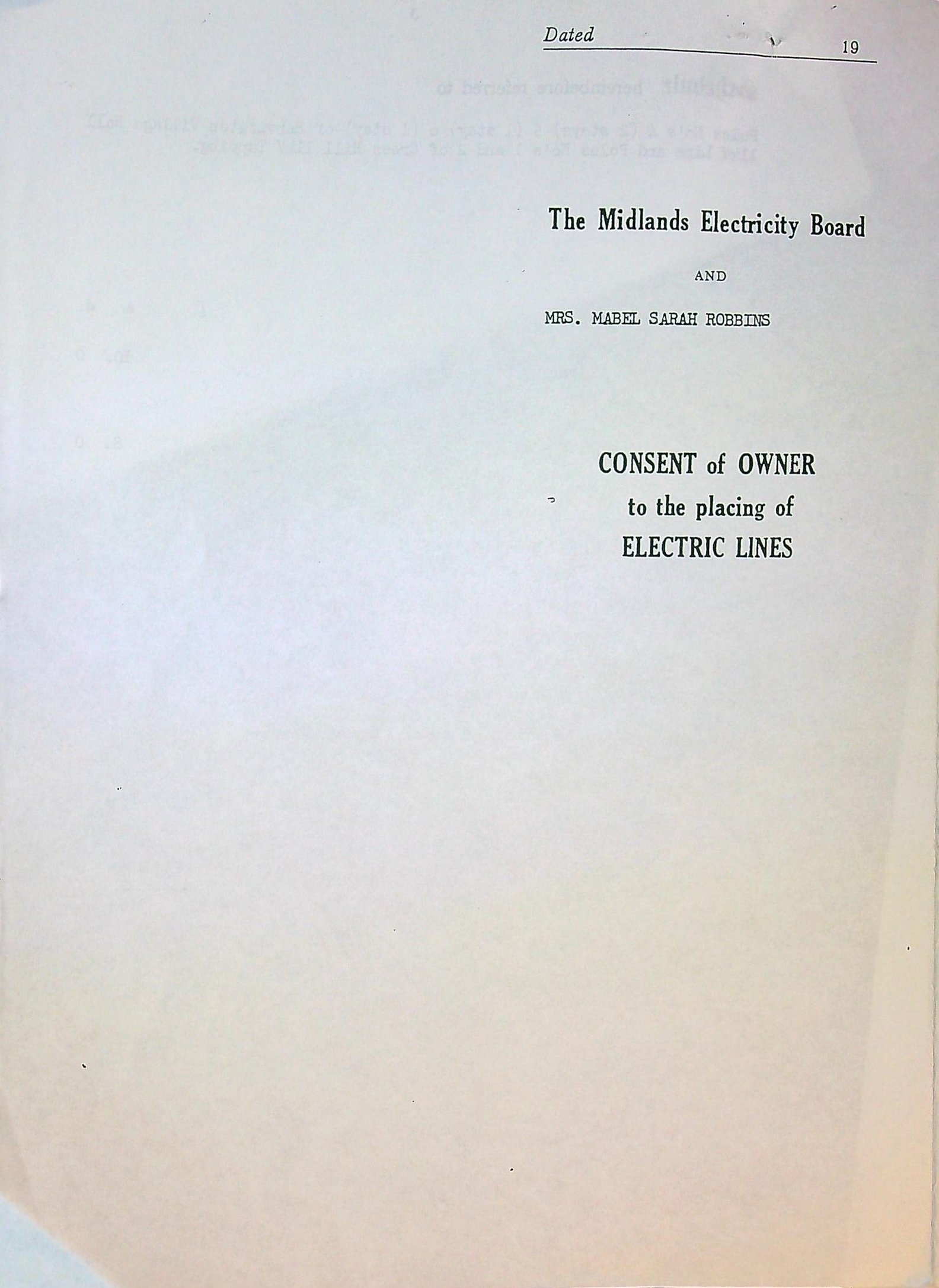
    SW01b:         Announcement.
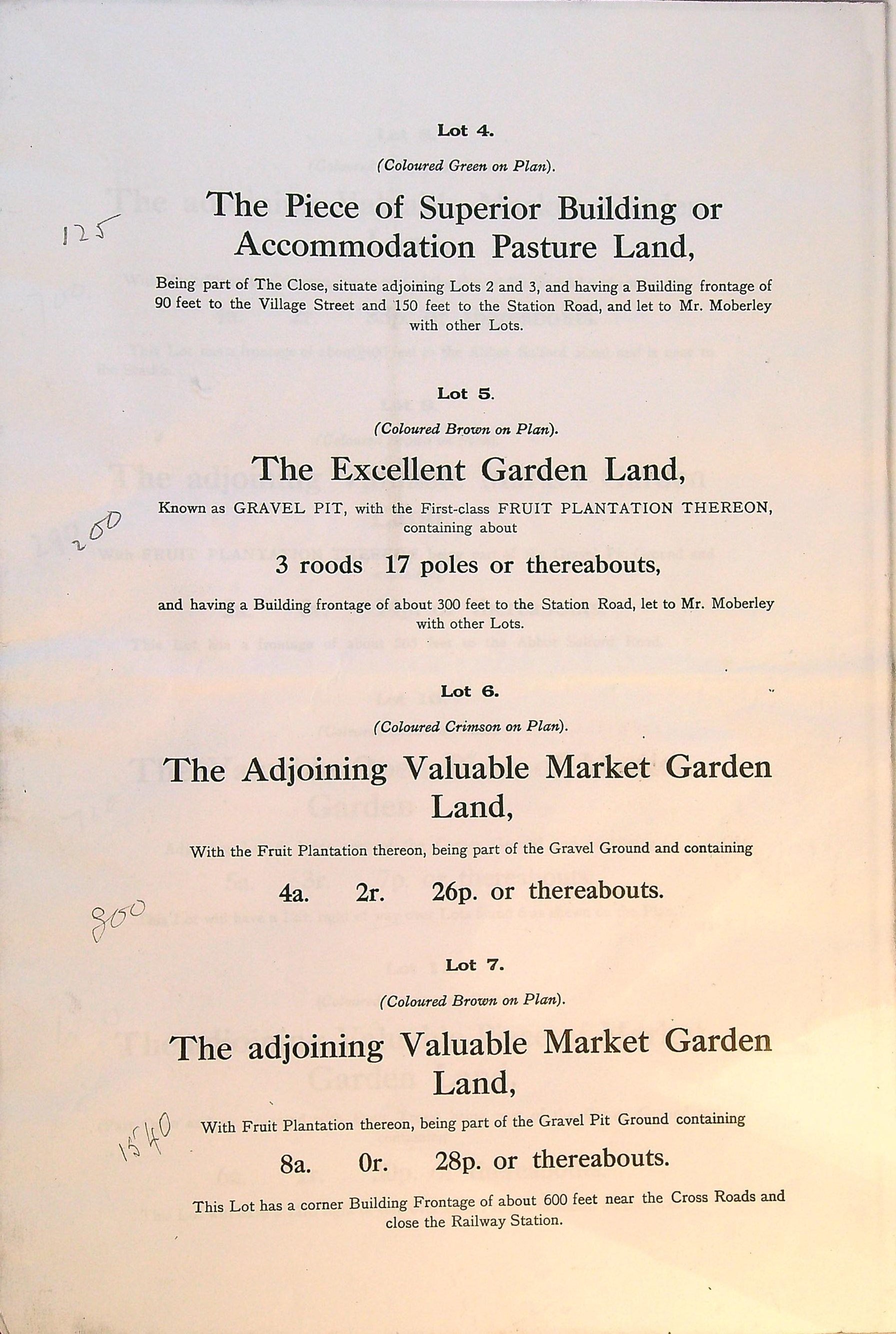

    SW01b:         Lots 4 to 7.

    Lot 4: - 90 frontage of ninety feet to Village Street and 150 feet to Station Road. Part of the Close, an area behind Langton, Dalkeith and Station Road, let to Mr C C Moberley in 1919. It was probably purchased by the Jones family of Pool House.

            By 1919 the old fields bordering what became Station Road (108 & 110) had become lots 5 to 9.

    Lot 5: - 3 roods & 17 poles. This small patch had been part of the field large known as Gravel Pit Ground. The village Hall was built here in 1931. Let to Mr C C Moberley in 1919 and laid down as orchard.

    Lot 6: - 4 acres 2 roods & 26 poles. Part of the old Gravel Pit Ground. Let to Mr C C Moberley in 1919 and laid down as orchard.

    Lot 7: - 8 acres 28 poles. Part of the old Gravel Pit Ground. Let to Mr C C Moberley in 1919 and laid down as market garden. Between lots 7 & 8 is a (12 foot) track. This feature did not appear on the 1838 tithe map and there is no sign of it now (2025).


    SW01c:         Lots 8 to 11.

    Lot 8: - 4 acres 2 roods 33 poles. Part of the old Gravel Pit Ground. Let to Mr C C Moberley in 1919 and laid down as market garden.

    Lot 9: - 2 acres 14 poles. Part of the old Gravel Pit Ground. Let to Mr C C Moberley in 1919 and laid down as market garden.

    Lot 10: - 5 acres 3 roods 7 poles. Mostly old field 107. Called Corner Ground in 1919. Let to Mr C C Moberley in 1919 and laid down as market garden.

    Lot 11: - 6 acres 1 rood poles. Partly old field 106. Called Corner Ground in 1919. Let to Mr C C Moberley in 1919 and laid down as market garden.


    SW01d:         Lots 12 to 15

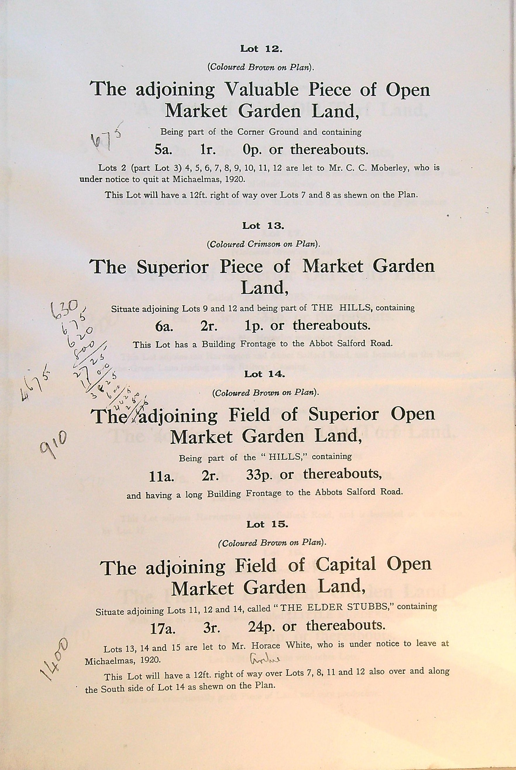
    Lot 12: - 5 acres 1 roods. Partly field 106. Called Corner Ground in 1919. Let to Mr C C Moberley in 1919, who had to leave by Michelmas 1920, laid down as market garden.

    Lot 13: - 6 acres 2 roods 1 pole. Bordering the Salford Road, mostly field 105 called The Hills. Laid down as market garden

    Lot 14: - 11 acres 2 roods 33 poles. Field 104 in 1838, bordering the Salford Road and the parish boundary, being part of The Hills. Laid down as market garden. This is (12 foot) track leading around this field and extending across lot 15. This feature was not on the 1838 tithe map. It does however still survive (2025) today with a gate leading onto the Salford Road. It now extends to Green Street Farm.

    Lot 15: - 17 acres 3 roods 24 poles. Fields 102 & 103 in 1838, bordering the parish boundary. Called The Elder Stubbs in 1919. Let to Mr Horace White in 1919 and laid down as market garden.


    SW01e:         Lots 16 to 19.

    Lot 16: - 2 acres 3 roods 15 poles. Field 115 in 1838, called The Down in 1919, bordered by the Salford Road, railway line and a short field lane. Let to Mr A Ludlow in 1919. Described as Rich old turf land.

    Lot 17: - 8 acres 3 roods 31 poles. Field 116 in 1838, called Far Moors in 1919, bordering the Salford Road and the short field lane. Let to Mr C C Moberley in 1919. Described as Rich old turf land.

    Lot 18: - 7 acres 26 poles. Field 117 in 1838, called First Moors in 1919, bordering the Salford Road and the parish boundary. Let to Mr H White in 1919. Described as Rich old turf land.

    Lot 19: - 7 acres 1 rood 21 poles. Part of field 116 in 1838, called Little Nurders in 1919, bordering the parish boundary and the railway line. This field or piece of land was created in the 1860s when the railway cut through the old fields 116 & 119. Let to Mr Horace White and described as garden land.
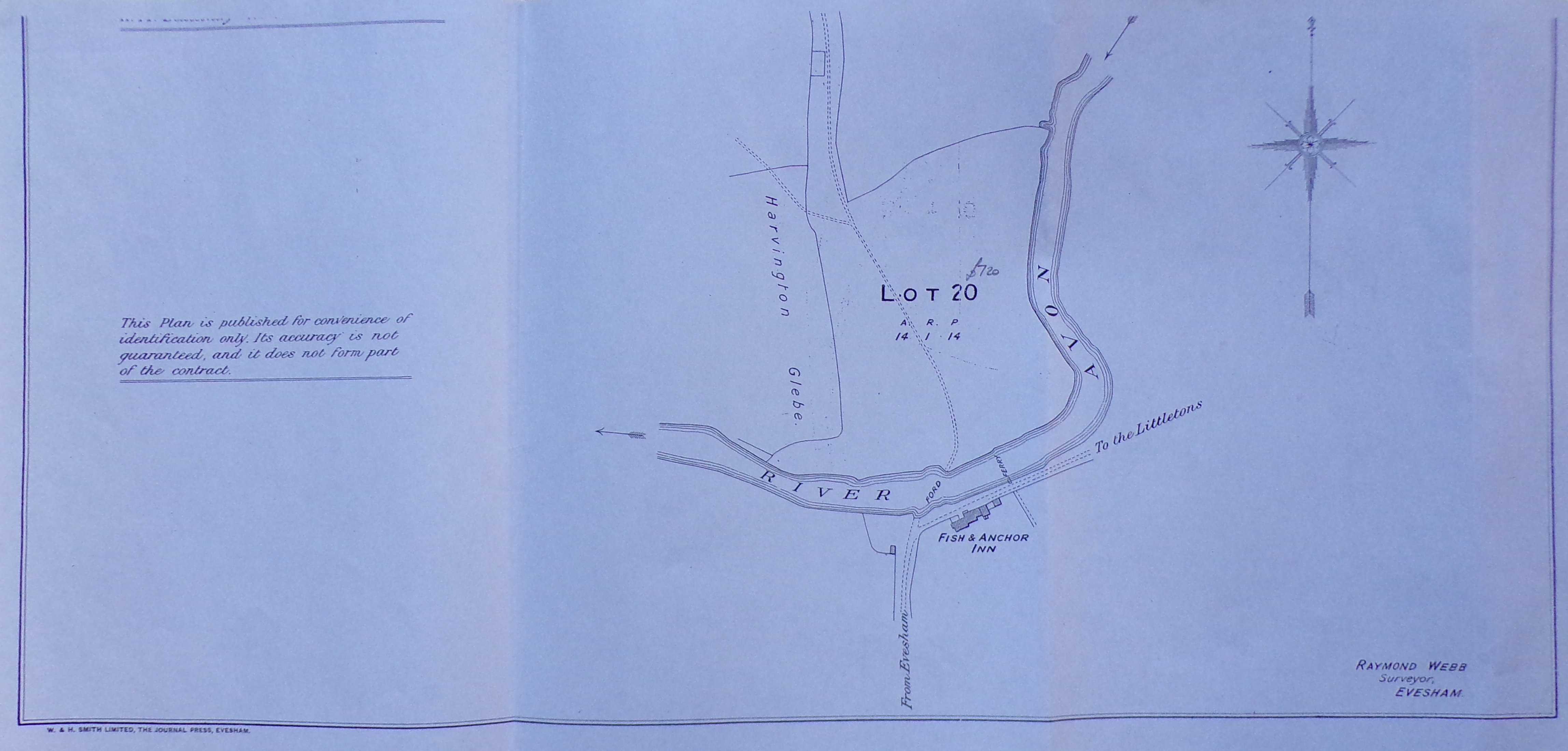

    SW01f:         Lot 20.

    Lot 20: - 14 acres 1 rood 14 poles. Fields 150 & 151 in 1838, called Anchor Meadow in 1919, bordering the River Avon and containing Anchor Lane and the approach to the crossing. Let to Mr A Ludlow in 1919. It is on a separate and smaller plan (sheet 2).


    SW01g:         Conditions of Sale.


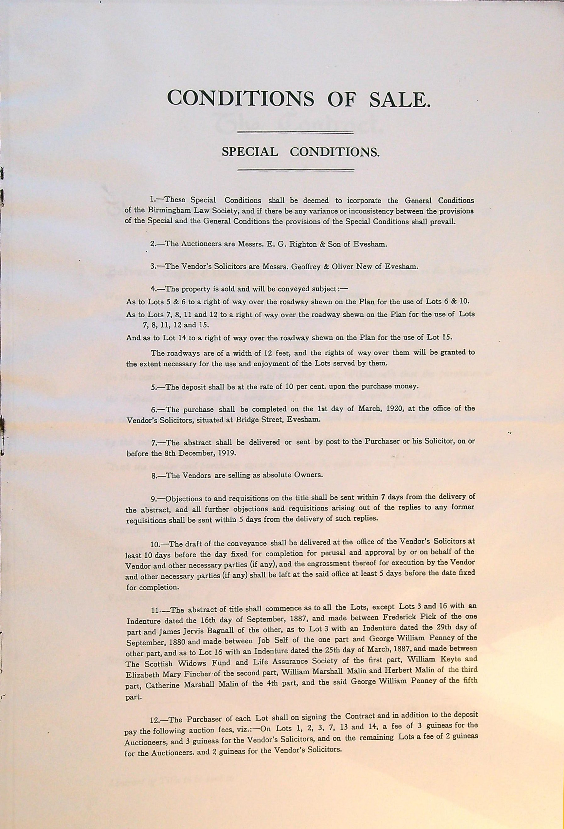
    SW01h:         The Contract.


    SW01i:         Large scale plan of the Penney Estate 1.


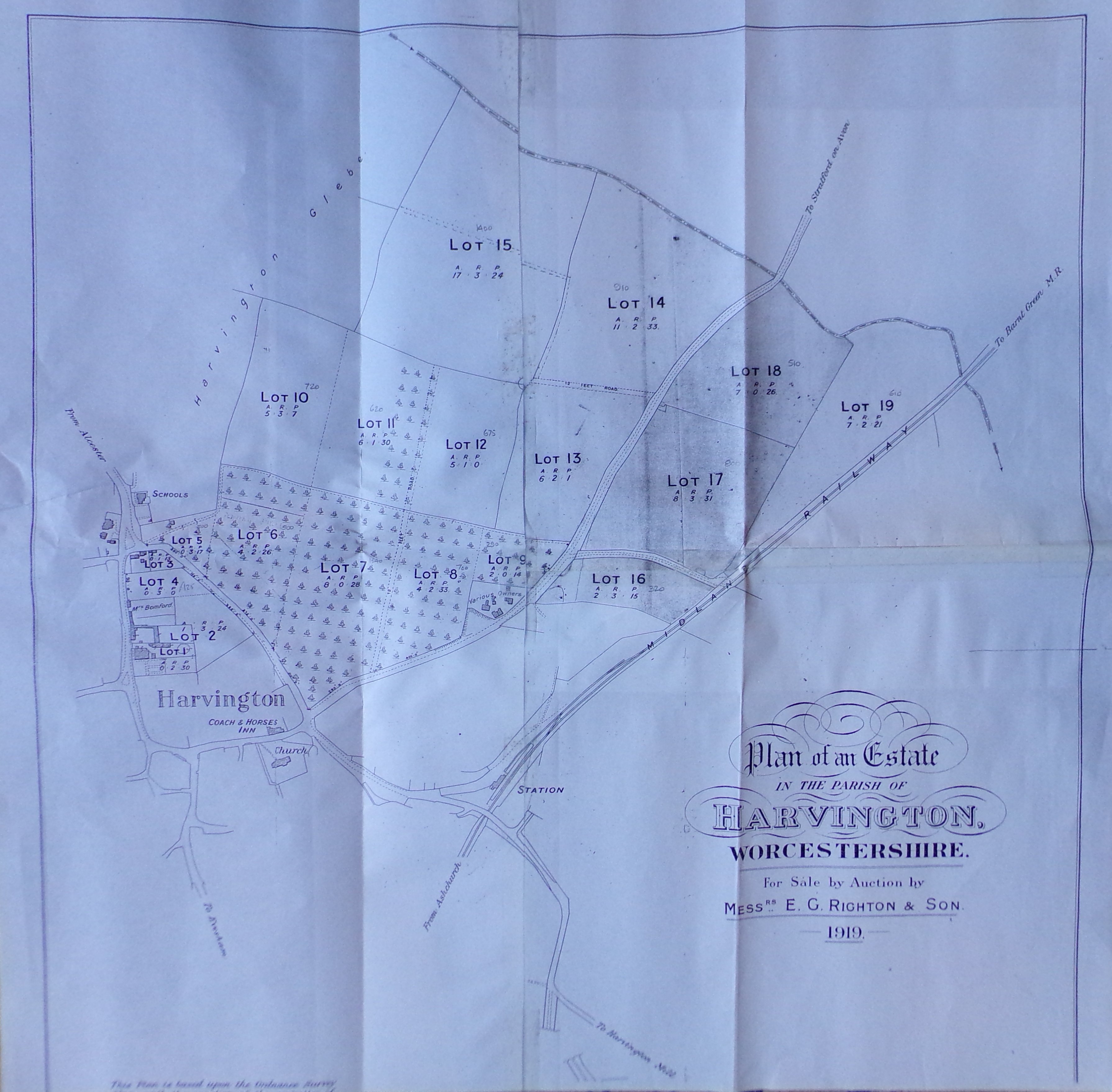
    SW01j:         Large scale plan of the Penney estate 2.


    SW01k:         Loose note by John Redman.

    SW02:         Conveyance dated 25th March 1965 - copy.

    SW02a:         Title page


    SW02b:         Page one


    SW02c:         Page two


    SW02d:         Plan


    SW02e:         Page three


    SW02f:         Page four

    SW03:         Probate to Edwin Joseph Robbins 13th July 1967 - copy.

    SW03a:         Page one


    SW03b:         Page one

    SW04:         Vesting Assent dated 19th April 1968 - copy.

    SW04a:         Title


    SW04b:         Page one


    SW04c:         Page two


    SW04d:         Page three


    SW04e:         Page four

    SW05:         Consent for electric lines dated 1969 - copy.

    SW05a:         Title


    SW05b:         Page one


    SW05c:         Page two


    SW05d:         Page three


    SW05e:         Page four

    SW06:         Conveyance dated 13 Jan 1970 - copy.

    SW06a:         Page one


    SW06b:         Page two

    SW07:         Conveyance dated 13 Jan 1970 - copy.

    SW07a:         Page one


    SW07b:         Page two


    SW07c:         Page three plan


    SW07d:         Page four

    SW08:         Wayleave agreement dated 28th July 1986 - copy.

    SW08a:         Page one


    SW08b:         Page two


    SW08c:         Page three


    SW08d:         Page four


    SW08e:         Page five

    SW09:         Electricity consent dated 28th July 1986 - copy.

    SW09a:         Page one


    SW09b:         Page two


    SW09c:         Page three


    SW09d:         Page four


    SW09e:         Page five


    SW09f:         Page five


    SW09g:         Page five


    SW09h:         Page five


    SW09i:         Page five


    SW09j:         Page five

    SW10:         Consent agreement dated 1st October 1987 - copy.

    SW10a:         Page one


    SW10b:         Page two

    SW11:         Probate to Mabel Sarah Robbins dated 14th August 1996 - copy.

    SW11a:         Page one


    SW11b:         Page two

    SW12:         Assent dated 11th June 1997 - photocopy.

    SW12a:         Page one


    SW12b:         Page two


    SW12c:         Page three


    SW12d:         Page four


    SW12e:         Page five


    SW12f:         Page five

    SW13:         Land Registry document dated 16th June 1997.

    SW13a:         Page one


    SW13b:         Page two


    SW13c:         Page three


    SW13d:         Page four


    SW13e:         Page five

    SW14:         Sale particulars dated 2000.

    SW14a:         Page one


    SW14b:         Page two


    SW14c:         Page three

    SW15:         Plan of the plot on which the property Conifers stands.

    SW15:         This was on the lower half of a photocopy containing on the upper half sw13e. The two appear to be unrelated.