HARVINGTON TITHE MAP OF 1838
Click once and twice to change viewing, then use the back arrow.
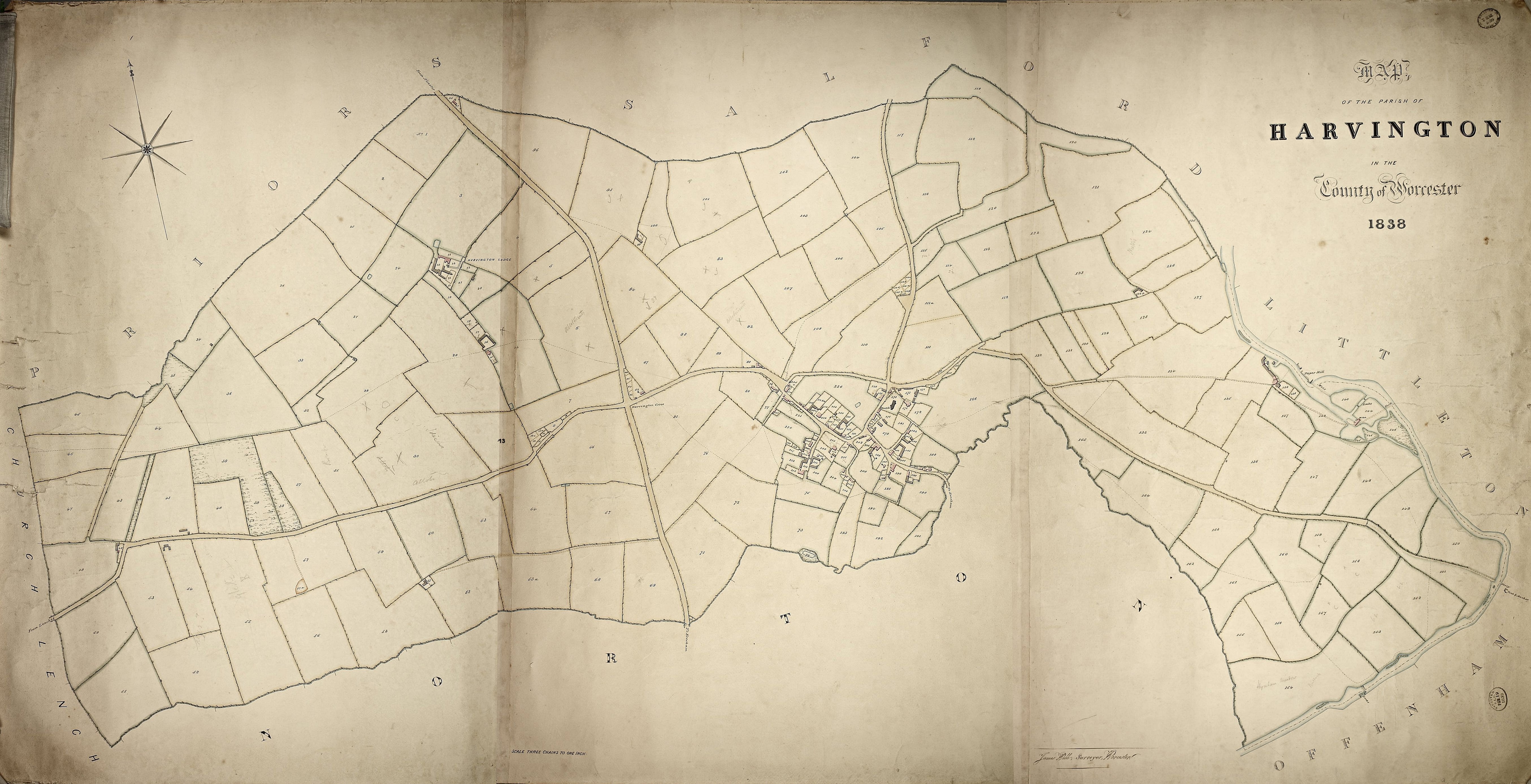
1838 TITHE MAP OF HARVINGTON

The above tithe map of Harvington (Worcestershire Record Office reference BA491), dated 1838, is a Manorial document. Harvington was owned by Worcester Cathedral and therefore came under the control the Dean & Chapter of Worcester. The map is on cloth and is approximately 6ft x 3ft, in good condition and shews Harvington's properties, fields, roads and river in fine detail. Those buildings depicted in pink are residential while those in grey are church, out- or farm buildings. Additions like footpaths and the occasional 'Allotment' are to be noted in pencil.

Each property and field has a number which referred to an accompanying 'Apportionment' Schedule, which would have shown who owned or rather occupied Harvington in 1838. Unfortunately, this all-important document has not been traced so we are at present left with the numbers without the key. In an attempt to overcome this loss, a schedule of the numbers on the map, indicating whether field, building etc., plus in time, additional information such as the tenant, has been created. It has already been possible to some extent to recreate, in part, the original through consulting other documents. A document amongst Deeds of Bank House relates to the sale of Bank House in 1870, see under Bank House in Houses. At the bottom of one of the pages is a chart of lands held by Bank House, albeit in 1870. The references in the document uses refer back to those used in the 1838 plan.

This map is so fine and has such detail with its numbered plots, it has been decided to use the map as a location base for the website as a whole.

Julian Rawes, Crooked Walls, 2015.

TITHE MAPS

Tithe, estate maps and early OS maps are a wonderful window into the past. Both served different purposes, two financial and one military. The map we are concerned with here is a Tithe map. There is much social history behind the creation of tithe maps and much has been written about them and the Enclosure Acts for which they were created.

Instead of attempting to go into the depth of detail that I don't have, I have lifted from the website of the Jesus Christ and Latter-Day Saints Church Archives site familyseach.org on Enclosure Records, an excellent article on the background to the reasons as to why these maps were created.

The enclosure movement was that process by which the common fields, shared pastures and scattered strips of arable land which made up the rural landscape of Mediaeval England gave way to the hedged fields and consolidated farms (Beech) of the 19th century. There was a national benefit in that agricultural productivity increased, but larger farmers benefited the most as smaller freeholders were often eased out in the process.

From 1235 manorial lords were allowed to enclose, with hedges, ditches, fences and stone walls, certain common land for arable or grazing purposes. This was known as assarting and meant that other parishioners no longer had common rights such as pasturage, pannage (letting pigs feed on acorns and beech-mast) and collection of wood etc. on these pieces of land (see TNA research guide D74). This system worked well on manors with large commons and wastes (moorland, woodland and marshland) because sufficient common lands survived. It obviously wasn’t popular in the largely arable open-field Midlands where commons were much smaller, and the large land-owners were keen on rearing more profitable sheep on the enclosed lands, thus displacing the people. Tate (The Parish Chest, 1983) has an excellent chapter on how the open-field system actually worked and how it was modernized by enclosure, and Hindle (Maps for Historians, 2002) has a discussion and good illustrations. Hollowell (Enclosure Records for Historians, 2000) is a detailed study of all types of enclosure, with many original examples and transcriptions, information about the process, the surveyors, their methods and the issues surrounding enclosure. The protest movement which resulted in much detail about participants in local newspapers, is detailed by Hugh Ward (Heroes or Villains? Family Revelations in Local Newspapers. Practical Family History Vol41, page 23-24.). Even by Elizabethan times (1558-1603) much land had been enclosed by amalgamation of strips by common consent, thus allowing farming of land in severalty (independently of others). Closely associated with enclosure is the consolidation of two or more farms into one holding, known as engrossing.

From the 16th century landlords were allowed to enclose arable land for pasturing sheep, cattle or deer. From 1601 a series of individual private or local governmental Enclosure Acts allowed owners of 75-80% of the parish land to force enclosure (inclosure was the legal term). Enclosure commissioners were appointed to reallocate land in the parish by acreage and quality to named land-owners, farmers and graziers; ordinary tenants and labourers are not mentioned in the records. From the mid-18th until the mid-19th centuries freeholders in most parishes in England and Wales were formally allowed to amalgamate their dispersed strips by exchange or purchase into more efficient farming units, as in this example quoted by Tate:

2 March 1765. Steeple Aston, Oxfordshire, Vestry Book (punctuation added)

It [is] agreed to change land in the Dean by Willm Wing, Richd Prentice and Richd Fox, for Willm Wing to have Richd Fox piece above the stile for his piece below, and for Richd Prentice to have three lands of Richd Fox next to his land under the Dean hedge shooting into Short Clay Furlong for his two lands in the Dean and for six years at Saint Micahill next. By we W. Wing, Richd Fox, Richd Prentice

The General Enclosure Acts of 1801, 1836 and 1845 eased the process but individual acts of parliament were needed; the legislation did not affect Ireland or Scotland. A rough guide to the main enclosure of counties by date is given below (from Hey).

Another website that should be consulted is that of the British Library.

A SCHEDULE TO THE ABOVE MAP
NUMBER TENANT IN 1838 DESCRIPTION DETAILS FROM DEEDS
1 not known Field
2 not known Field
3 not known Field with small pond
4 not known Field
5 not known Field
6 not known Field with 'allotments' in pencil and foot path
7 Not known Sideland Piece
8 Not known Taylors Hill, plot on the Leys Road
9 Not known Taylors Hill, plot on the Leys Road
10 Not known Taylors Hill, plot on the Leys Road
10a Not known Taylors Hill, plot on the Leys Road
11 Not known Taylors Hill, plot on the Leys Road
12 Not known Taylors Hill, plot on the Leys Road
12a not known Plot on the Leys Road
13 Not known Wellspring field
14 Not known Barrow Piece, with pond and foot path
15 not known Glebe Farm House
16 not known Glebe Farmyard
17 not known Small field
18 not known Small field
19 not known Small field
20 not known Field with farm building
21 not known Small field
22 not known Small field
23 not known Harvington Lodge, outbuildings, farmyard, gardens etc.
24 not known Field with pond
25 not known Field
26 not known Field
27 not known Field, possibly with tiny structure
28 not known Field with footpath
29 not known Field with footpath. The southern part of this field was called Barrow Field, a suggestive name indicating a prehistoric tumuli or barrow.
30 not known Field with 'allotments' in pencil
31 not known Field
32 not known Field with tiny structure and footpath
33 not known Field
34 not known Field with tiny structure
35 not known Possibly woodland
36 not known Field with footpath
37 not known Field
38 not known Possibly woodland
39 Possibly Bank House suggests woodland in 1838 Bank House Deeds 1870 has coppice.
40 Possibly Bank House The Leashow in 1870 Bank House Deeds 1870.
41 not known Field with two farm buildings
42 not known Long narrow field reminicent of old strip system
43 not known Field
44 not known Field with footpath
44a not known Appears to be a lane going to number 35
45 not known Field
46 not known Field with footpath
47 not known Field
48 not known ?? House, once two shepherds cottages
49 not known Field with footpath
50 not known Field
51 not known Field
52 not known Field
53 not known Field
54 not known Field with farm buildings
55 not known Field
56 Possibly Bank House Far Leys in 1870 Bank House Deeds 1870 has Far Leys.
57 not known Field through which is a track to 57a
57a not known Appears to be a large pit in number 57 - field
58 Possibly Bank House Big Leys in 1870 Bank House Deeds 1870 has Big Leys.
59 Possibly Bank House The Ten Acres in 1870 Bank House Deeds 1870 has The Ten Acres.
60 Possibly Bank House OldField Bank House Deeds 1870 has Old Turf Ground.
61 Possibly Bank House Farm buildings Bank House Deeds 1870 has Barn Rickyard.
62 Possibly Bank House Field with track leading to 61 Bank House Deeds 1870 has Barn Ground.
63 Possibly Bank House Short Lands in 1870 Bank House Deeds 1870 has Short Lands.
63a Possibly Bank House Field with track leading to 61 Bank House Deeds 1870 has Upper Norbrook.
64 not known Field with pond
65 not known Small thin plot alongside Leys Road
66 not known Brach Furlong
67 not known Banlands Furlong, with pond
68 Possibly Bank House Norbrook Furlong, with track Bank House Deeds 1870 has First Norbrook.
69 Possibly Bank House Norbrook Furlong, with track Bank House Deeds 1870 has Arch Ground.
70 Possibly Bank House Small patch of woodland on corner of Evesham Road and the Parish boundary Bank House Deeds 1870 has Garden.
71 Possibly Bank House Brook Furlong in 1870 Bank House Deeds 1870 has Brook Furlong.
72 Possibly Bank House Beckstone Bank House Deeds 1870 has Beckstone.
73 Possibly Bank House Pool Chase in 1870 Bank House Deeds 1870 has Pool Chase.
74 Possibly Bank House Pond surrounded by scrubland Bank House Deeds 1870 has Fish Pool and Spinney.
75 Possibly Bank House Field with two footpaths Bank House Deeds 1870 has Crab Tree Leys.
76 not known Field with three footpaths
77 not known Small field
78 not known The forerunner of Cedar Lodge and farm building
79 not known Tiny strip of land along side village street
80 not known Field
81 not known Field with footpath
82 not known Golden Cross with two small outbuildings
83 not known Plot
84 not known Plot
85 not known Plot
86 not known Plot
87 not known Field
88 not known Field
89 not known Field
90 not known Hop Pole plus two outbuildings and 'Spinks Cottage'
91 not known Field
92 not known Field with allotments in pencil
93 not known Field
94 not known Field
95 not known Field with small pond
96 not known Field
97 not known House at the Brickyards
98 not known Plot
99 not known Farm building later to become Green Street Farm
100 not known Field with small pond
101 not known Field
102 not known Field
103 not known Field
104 not known Field
105 not known Field
106 not known Field
107 not known Field
108 not known Field with footpath
109 not known Split into small plots numbered a-f, on site of the Marl Hole
110 not known Field
111 not known Field
111a not known Field
112 not known Field
113 not known Field
114 not known Field
115 not known Field
116 not known Field
117 not known Field
118 not known Field
119 not known Field
120 not known Field
121 not known Field
122 not known Field
123 not known Field
123a not known Langlands
124 not known Field
125 not known Long narrow field
126 not known Field
127 not known Field bordering river
128 not known Field
129 not known Field
130 not known Field with two small buildings, one appears to be a house (pink)
131 not known Field
132 not known Field
133 not known Field with footpath
134 not known Field bordering river with track to Harvington Mill passing through
135 not known Field bordering river with track to Harvington Mill passing through
136 not known Field with tiny structure
137 not known Field with tiny structure
138 not known Small field
139 not known Small field with outbuilding
140 not known Harvington Mill House
141 not known Harvington Mill House outbuildings
142 not known Area of land by river with footpath
143 not known Area of land in river by Mill
144 not known Harvington Mill and land
145 not known Two pieces of land in river
146 not known Island in river
147 not known Field with footpath
148 Possibly Bank House Field by river with footpath Bank House Deeds 1870 has Meadow.
149 not known Field by river with footpath
150 not known Field by river with footpath
151 not known Field by river with footpath
152 not known Field by river with footpath
153 not known Field by river with footpath
154 not known Field by river with footpath 'Hynham Meadow' in pencil
155 not known Field
156 not known Field
157 not known Field with tiny structure
158 not known Field with footpath
159 not known Field
160 not known Field with footpath
161 not known Field with footpath
162 not known Field with footpath
163 not known Field
164 not known Field with footpath
165 not known Field with footpath
166 not known Field with footpath
167 not known Strip of land alongside Anchor Lane
168 not known Strip of land alongside Anchor Lane
169 not known Strip of land alongside Anchor Lane
170 not known Strip of land alongside Anchor Lane
171 not known Manor Farm, yard outbuildings and adjacent land
172 not known Small field
173 not known Church
174 not known Candle Cottage
175 not known Church House
176 not known The Hopkiln and land possibly plus James & Pear Tree Cottage
177 not known Crooked Walls
178 not known Plot adjacent to 177
179 not known Field behind Crooked Walls and The Hopkiln
180 not known Blacksmith Cottages and cider press building
181 Possibly Bank House Plot where the Cemetery now is Bank House Deeds 1870 has Orchard.
182 not known The Shakespeare and outbuildings
183 not known The Limes, yard and outbuildings
184 not known Thatcholm
185 not known Thatchways
186 not known House long gone
187 not known Plot
188 not known Field
189 not known Firbank and outbuildins
190 not known Field
191 not known Field
192 not known Field
193 not known Field with footpath
194 not known Field with footpath
195 not known Field with footpath
196 not known The Laurals with outbuildings
197 Bank House Bank House Bank House Deeds 1870 has Two cottages and garden.
198 Bank House Two cottages in grounds of Bank House, now built over Bank House Deeds 1870 has Cottage and garden.
199 Possibly Bank House Small field with tiny structure Bank House Deeds 1870 has (part) Garden.
200 not known Field
201 Bank House Property including Bank Cottage, The Malthouse, Malthouse Cottages Bank House Deeds 1870 has Four cottages and gardens.
202 not known Property including The Old Bakery and The Retreat
203 not known The Rectory including outbuildings and gardens
204 not known Filed with footpath
205 not known Property long demolished
206 not known Finch 1
207 not known Finch 2
208 not known Field
209 Possibly Bank House Field with small building Bank House Deeds 1870 has rickyard & orchard.
210 Possibly Bank House Stables belonging to The Grange Bank House Deeds 1870 has barn, farmyard &c.
211 Possibly Bank House Ivy Cottage with outbuilding Bank House Deeds 1870 has Cottage and garden.
212 Possibly Bank House The Grange with garden and yard Bank House Deeds 1870 has house, garden, stabling &c.
213 not known Field
214 not known Property, yard and outbuildings, now gone
215 Possibly Bank House Property, yard and outbuildings, now gone Bank House Deeds 1870 has orchard.
216 not known Grove Cottages, yard and outbuilding
217 not known Plot
218 not known Plot
219 not known Plot
220 not known Field
221 not known Field
222 not known Forerunner of Mona & Horse Shoe Cottages
223 not known Glebe Cottages and plots
224 not known Pool House, Cottage and Green Cottage
225 not known Building nest to Pool Cottage
225a not known Plot with building
226 not known Field with pond
227 not known Ye Olde Cottage with separate field
228 not known Dream Cottages
228a not known Outbuildings and land adjacent to Langton House
229 not known Langton House, outbuildings and gardens
230 not known Coley Cottages 1 and land
231 not known Coley cottages 2
232 not known Tiny piece of land
233 not known Dalkeith, outbuildings and gardens
234 not known Old house long demolished
235 not known Field and building
THE END